A weekly update describing soil moisture across the country to help assess whether severely to extremely dry conditions are occurring or imminent. Regions experiencing these soil moisture deficits are deemed “hotspots”. Persistent hotspot regions have the potential to develop into drought.
Facts: soil moisture
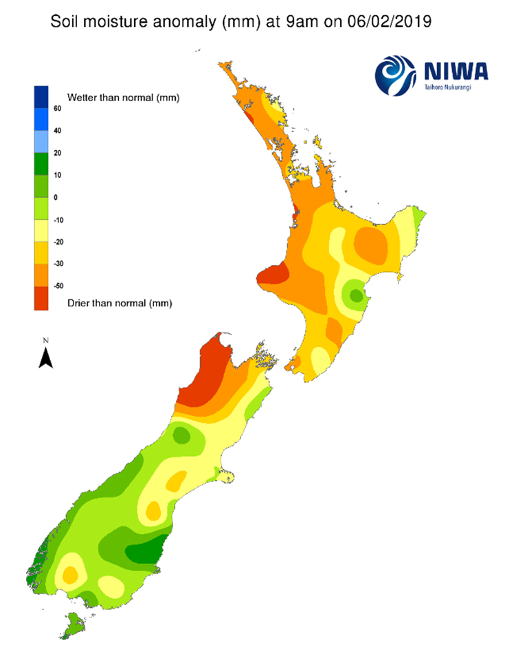
Across the North Island, soil moisture levels continued to decrease nearly everywhere during the past week. The only locations that saw slight increases were eastern Whangarei district and eastern Gisborne. Soil moisture levels as of 13 February are below normal for the vast majority of the North Island, with the driest soil compared to normal for this time of year in the New Plymouth District, parts of western coastal Waikato and the Aupouri Peninsula. The wettest soils compared to normal are located in a portion of Hastings District, eastern Gisborne, along with eastern Whangarei District where the soil moisture levels are near normal.
Most areas deemed hotspots continued to expand during the past week in the North Island. The only exception is the hotspot in Northland that dissipated in parts of the eastern Far North and Whangarei Districts. A large hotspot encompasses big areas of western Northland, Auckland, and Waikato including parts of the Coromandel Peninsula. Additional hotspots are currently in place in coastal Taranaki, parts of Manawatu-Whanganui, Wellington City and Porirua, northern Hawke’s Bay along with parts of Gisborne and Bay of Plenty.
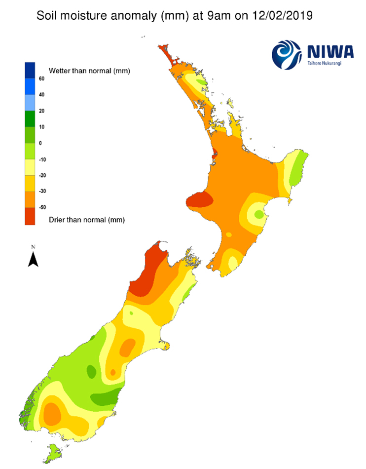
Across the South Island, soil moisture levels decreased nearly everywhere during the past week with little rainfall in the north, south and east. The driest soils across the South Island compared to normal for this time of the year are found in western Tasman and Buller District, while the wettest soils for this time of the year are found in north coastal Otago and coastal Fiordland where the soil is slightly wetter than normal.
The previous hotspots encompassing Nelson and portions of Tasman, along with a small area in northern Marlborough, remain in place, while the hotspots in the Ashburton and Waimate districts have strengthen and expanded. In addition, new hotspots have developed in eastern Banks Peninsula, parts of the Hurunui District, an area south of Dunedin City, and small portions of Southland.
Outlook and soil moisture
In the North Island, mostly tranquil weather and rainfall below normal is expected in the upcoming week. A weakening front may deliver scattered showers (5 mm or less) to the lower North Island on Friday (15 February). Showers are possible, mainly for central and northern areas, on Sunday and Monday (17-18 February) with rainfall totals up to 10 mm possible in Waikato and the higher terrain in Gisborne and the Central Plateau.
Total weekly rainfall will likely stay below 10 mm for the majority of the island. But the higher terrain in Gisborne and the Central Plateau, along with western Waikato, may see weekly rainfall exceeding 15 mm. Due to the meagre rainfall anticipated, soil moisture levels are expected to decrease nearly everywhere in the upcoming week. This will likely lead to an expansion of most hotspots across the island.
For the South Island, a front will move up the West Coast on Thursday (14 February) bringing up to 40 mm in places. However, the upper West Coast and Tasman will receive little if any rainfall from the same event. Another weak front can bring additional 5-10 mm of rain to the lower South Island on Friday (15 February). Mostly tranquil weather is expected from Saturday (16 February) through early next week with only isolated showers possible. On Tuesday (19 February) a weak front may bring additional rainfall to the lower West Coast and scattered showers to Southland and Otago.
Total weekly rainfall may exceed 50 mm in the lower and central West Coast, up to 30 mm in parts of Southland, generally less than 15 mm in Otago and lower Canterbury, and little to any rainfall elsewhere. Due to the expected rainfall amounts, the majority of the current hotspots will likely intensify and expand in the upcoming week. The only exception may be the small hotspots in parts of Southland that will remain constant or slightly weaken.
Background
Hotspot Watch a weekly advisory service for New Zealand media. It provides soil moisture and precipitation measurements around the country to help assess whether extremely dry conditions are imminent.
Soil moisture deficit: the amount of water needed to bring the soil moisture content back to field capacity, which is the maximum amount of water the soil can hold.
Soil moisture anomaly: the difference between the historical normal soil moisture deficit (or surplus) for a given time of year and actual soil moisture deficits.
Definitions: “Extremely” and “severely” dry soils are based on a combination of the current soil moisture status and the difference from normal soil moisture (see soil moisture maps)
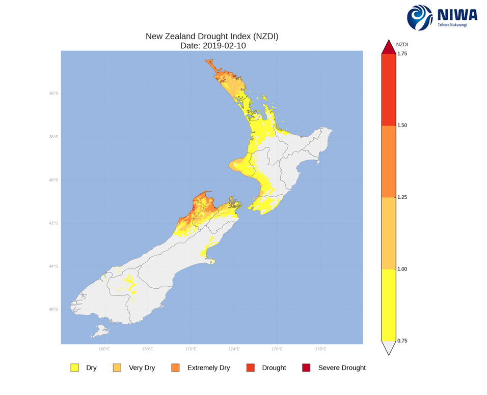
Hotspot: A hotspot is declared if soils are "severely drier than normal" which occurs when Soil Moisture Deficit (SMD) is less than -110 mm AND the Soil Moisture Anomaly is less than -20 mm