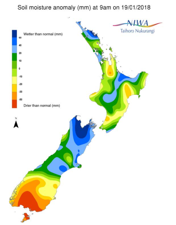
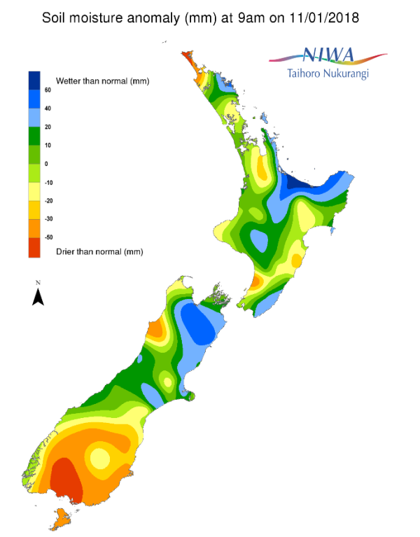
A weekly update describing soil moisture across the country to help assess whether severely to extremely dry conditions are occurring or imminent. Regions experiencing these soil moisture deficits are deemed “hotspots”. Persistent hotspot regions have the potential to develop into drought.
Facts: Soil Moisture
The driest soils across the North Island compared to normal for this time of the year are found in the Waikato, northwest Taranaki, along the Kapiti Coast to Horowhenua, and in Hawke’s Bay, while the wettest soils are found in eastern Northland.
Current hotspots are located in portions of Kapiti Coast, Horowhenua, and in the central Waikato.
The driest soils across the South Island compared to normal for this time of the year are found in Southland and Otago, while the wettest soils are found in Tasman, Nelson, and Marlborough.
The only current hotspot in the South Island is a sizeable one which covers far southern Canterbury as well as a majority of Otago and Southland.
Outlook and Soil Moisture
While scattered rain is forecast about the country early next week, a large ridge of high pressure is expected to move in during the mid-week, bringing a return to the drier weather.
On Monday 5 to 15 mm is expected across a good portion of the North Island, especially in the west and north. Isolated showers and thunderstorms are then possible on Tuesday with a general 5 to 15 mm possible, though higher amounts are possible in any thunderstorm. Mostly dry weather is expected to be the theme for the remainder of the week thereafter.
In the South Island, rainfall totals of 5 to 15 mm are possible in along the West Coast and across the top of the island on Monday with generally less than 5 mm across Southland and Otago. However, there is the potential for isolated thunderstorms across the interior, which could cause higher rainfall totals in some locations. A weak front may bring a bit of rain to the west on Wednesday before the island dries out for the rest of the week.
Soil moisture may increase somewhat for the North Island to start the week, but decline once again to round out the month. In the South Island, soil moisture levels are expected to remain about the same or decline slightly.
Long Range Outlook
Model forecast guidance indicates that the end of January into February could turn rather active across the Tasman and Coral Seas. The marine heatwave in the Tasman Sea has persisted and may contribute heat and moisture to approaching weather systems. Thus, wetter than normal rainfall patterns may emerge for much of New Zealand during the first half of next month.
Background:
Hotspot Watch: a weekly advisory service for New Zealand media. It provides soil moisture and precipitation measurements around the country to help assess whether extremely dry conditions are imminent.
Soil moisture deficit: the amount of water needed to bring the soil moisture content back to field capacity, which is the maximum amount of water the soil can hold.
Soil moisture anomaly: the difference between the historical normal soil moisture deficit (or surplus) for a given time of year and actual soil moisture deficits.
Definitions: “Extremely” and “severely” dry soils are based on a combination of the current soil moisture status and the difference from normal soil moisture (see soil moisture maps)


