It’s a mountaineer’s worst nightmare – a loud crack, then a cascade of snow and ice hurtling downhill.
Avalanches have claimed the lives of 27 people in New Zealand in the past two decades.
Knowing exactly when and where an avalanche might occur is a bit like trying to predict lightning.
But, with NIWA’s help, the Mountain Safety Council (MSC) can effectively forecast the degree of avalanche danger for those venturing into the backcountry mountains.
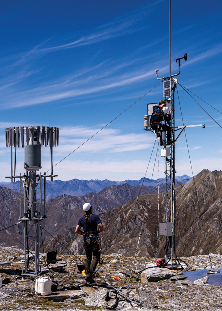
It’s one of just a range of services flowing from the data gathered by a network of 11 high elevation weather stations set up and maintained by NIWA’s environmental technicians.
Hydrologist Dr Christian Zammit is the current custodian of NIWA’s alpine weather network and its genesis.
The genesis of the network can be traced back to the mid-2000s. At the time, growing awareness of climate change was starting to prompt questions about New Zealand’s future water supply.
Snow plays a significant role in both national water flows and the economy. Snowmelt contributes to as much as 30% of the intake of major hydroelectricity lakes, and large areas of the South Island rely on meltwater for irrigation. Snowflakes themselves are big business – in 2019 alone, there were about 1.7 million visitors to ski fields in New Zealand.
Understanding the amount, seasonal nature and long-term changes to snow and ice is hugely important – especially with a warming climate,” says Zammit.
Before the NIWA snow and ice monitoring network, there was no infrastructure to help measure how much water was stored as snow in our mountains.
NIWA’s solution was hugely ambitious – a network of alpine weather stations that would record the depth, density and temperature of snow, as well as a range of other climate measurements such as precipitation, wind speed, temperature and humidity.
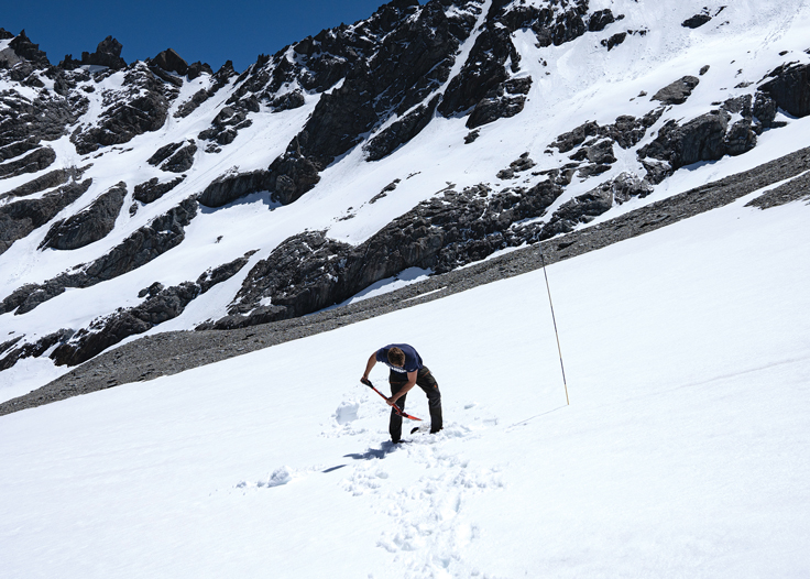
In 2008, after years of intensive planning, NIWA technicians headed into the mountains to start installing the equipment needed to gather that data.
It was no easy network to set up. Situated in some of New Zealand’s harshest environments, the stations had to endure freezing temperatures, gale-force winds, lightning, heavy rain and, of course, heavy snow.
They also needed to deal with kea – the mountain parrots notorious for pecking and ripping apart anything they get their beaks on.
NIWA’s environmental monitoring technicians learnt many lessons the hard way. The wind sensors, for example, require special modifications to thwart the inquisitive birds.
Five years later, however, the snow and ice monitoring network was complete, made up of 10 high elevation stations running the length of the Southern Alps and one on Mount Ruapehu.
With specialist recording instruments in place from Fiordland to Tongariro National Park, the network covers a representative range of distinct high-altitude areas between 800 and 2200 metres above sea level.
The stations, and the long-term data series they provide, play a pivotal role in delivering insights into the ever-changing alpine climate to everyone from power planners and hydrologists, to farmers and ski field operators.
It is also crucial in helping the MSC shape its avalanche forecasts for recreational backcountry users, such as mountaineers, ski tourers, winter trampers or anyone else venturing into vulnerable areas.
Unlike ski fields, backcountry mountains are neither patrolled nor controlled, so understanding the condition of the snowpack and the avalanche threat it poses is vital.
The MSC’s forecasts are compiled by experienced snow safety professionals with expert knowledge of avalanche phenomena. They use data from the NIWA network, coupled with direct observations from the field.
“Over the course of days, weeks and months, forecasters can start to build an understanding of what the snowpack is doing and how it is changing. The continuous flow of data from these stations is really important,” says MSC operations manager Nathan Watson.
Avalanche forecasts covering 12 alpine regions are published daily during the snow season on the MSC’s Avalanche Advisory website.
They provide a rating for the avalanche danger – low, moderate, considerable, high, and extreme – across three elevation bands: subalpine, alpine and high alpine.
“In a storm cycle, usually no one is in the field observing the snow – there’s no one out heli-skiing, climbing or touring.
“So, you’re relying on the stations and the weather data to paint a picture of what’s going on.”
The value of those stations, and the information they supply, will only go up as our climate warms.
Zammit says while researchers expect higher snowlines and less snow in future years, that will not necessarily mean less avalanche danger.
There might be fewer snow days, says Zammit, but expect larger amounts of snow falling during storm events.
“With climate change, the extremes get more extreme.”
Even more reason to ensure the data keeps flowing off the mountains.
This story forms part of Water and Atmosphere - August 2021, read more stories from this series.