For 10 November 2016
A weekly update describing soil moisture across the country to help assess whether severely to extremely dry conditions are occurring or imminent. Regions experiencing these soil moisture deficits are deemed “hotspots”. Persistent hotspot regions have the potential to develop into drought.
Facts: soil moisture
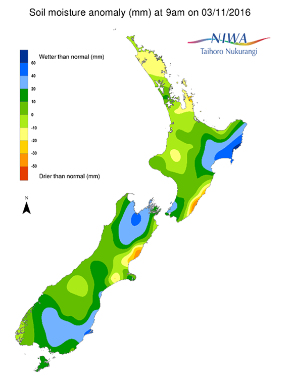
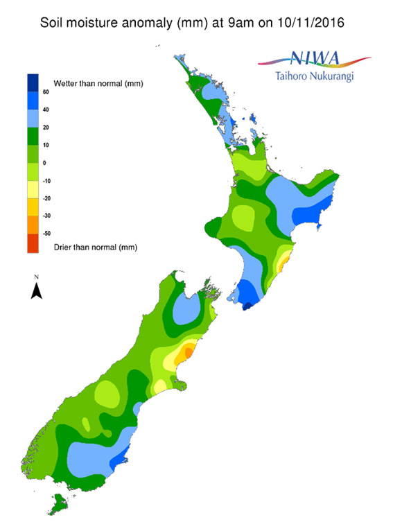
Across the North Island, soil moisture levels have generally increased since this time last week. Substantial increases were observed in Wellington and southern Wairarapa, along with Northland, Auckland, and the Coromandel Peninsula. Smaller increases also occurred in Waikato, Bay of Plenty, Taranaki, and northern Manawatu. Meanwhile, slight decreases in soil moisture levels were observed in coastal Gisborne. The driest soils across the North Island compared to normal for this time of the year are found along the southern coast of Hawke’s Bay, while the wettest soils for this time of the year are found in far southern Wairarapa.
Across the South Island, soil moisture levels have generally changed little since this time last week. Slight decreases were observed in western Marlborough and eastern Tasman, while slight increases were observed in southern Canterbury, coastal Otago, and in Fiordland. The driest soils on the South Island compared to normal for this time of the year are still found in coastal Hurunui district, where a small area has soils that are extremely drier than normal, while the wettest soils for this time of year are found in coastal Otago.
Outlook and soil moisture
For the North Island, a storm will deliver moderate to briefly heavy rain from this evening through midday Saturday (12th November) for Northland, Auckland, Waikato, and Bay of Plenty, where 10-20 mm will be likely. Isolated amounts up to 35 mm will be possible in Bay of Plenty. While 10-20 mm is also likely in the southern North Island, lower amounts of 5-10 mm are expected along the eastern coast. The odd shower or two may occur on Sunday, but any rainfall will be minimal. More significant rainfall is expected from Monday evening through Tuesday afternoon, with 20-30 mm possible in many locations and isolated amounts up to 50 mm in western regions. However, lighter amounts around 10 mm are expected along the east coast. Showers on Wednesday and Thursday (16th and 17th November) may produce another 10-15 mm for much of the North Island, although minimal amounts are expected along the east coast.
Official hotspots are unlikely to develop across the North Island during the next week, but little if any improvement is anticipated along the southern coast of Hawke’s Bay. While the rest of the east coast may become slightly drier next week, soil moisture levels are likely to increase for the majority of the North Island.
For the South Island, substantial amounts of rain will fall in northern and central regions from this evening through Saturday morning (12th November). Rainfall amounts of 25-35 mm are expected from Tasman to Canterbury, with isolated amounts near 100 mm along the West Coast. Lower amounts of 10-15 mm are expected in Marlborough, with 5-15 mm in Otago and minimal rainfall in Southland. Isolated showers on Sunday will produce small rainfall amounts in the South Island. More significant rain will fall along the West Coast from Monday evening through midday Tuesday (15th November), with amounts of 50-100 mm possible. However, only minimal rainfall will occur in the eastern South Island. Additional showers will be possible throughout the South Island on Wednesday and Thursday, with many locations receiving 10-15 mm.
The current hotspot in coastal Hurunui district is expected to dissipate in the next week due to substantial rainfall. In fact, soil moisture anomalies in all of Canterbury will likely improve in the coming seven days. Only Southland may see soils become slightly drier in the next week.
Background
Hotspot Watch a weekly advisory service for New Zealand media. It provides soil moisture and precipitation measurements around the country to help assess whether extremely dry conditions are imminent.
Soil moisture deficit: the amount of water needed to bring the soil moisture content back to field capacity, which is the maximum amount of water the soil can hold.
Soil moisture anomaly: the difference between the historical normal soil moisture deficit (or surplus) for a given time of year and actual soil moisture deficits.
Definitions: “Extremely” and “severely” dry soils are based on a combination of the current soil moisture status and the difference from normal soil moisture (see soil moisture maps).