New Zealand scientists are investigating active undersea volcanos, north of New Zealand. New images reveal the impacts of a significant eruption on the seafloor.
NIWA research vessel Tangaroa has just mapped the Kermadec volcano that erupted 800 kilometres north east of Tauranga, on 19 July 2012, producing a pumice raft the size of Canterbury. Tangaroa recently embarked on a 23-day voyage of discovery in the Kermadecs, north of New Zealand, to study the volcanic chain that stretches for 1000 kilometres north from Bay of Plenty.
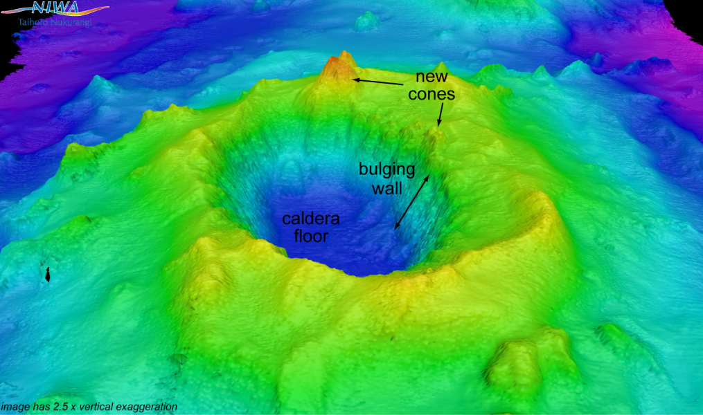
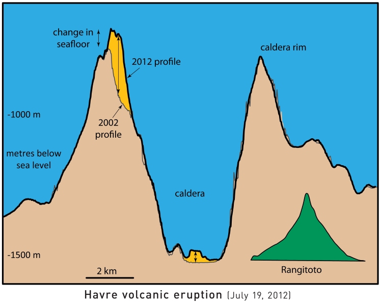
"When we mapped the area yesterday", says NIWA ocean geology scientist Dr Joshu Mountjoy, "we found a new volcanic cone which has formed on the edge of the volcano, towering 240 metres above the crater rim.
"It is fantastic to be able to record the change on the seafloor following these kinds of events."
The Havre volcano eruption was strong enough to breach the ocean surface from a depth of 1100 metres. It produced clouds of ash visible by satellite, and a pumice raft that covered an area of 22,000 square kilometres.
The voyage, led by NIWA's volcanologist Dr Richard Wysoczanski, comprises geology and biology scientists from NIWA, GNS Science, as well as students from Victoria University of Wellington and The University of Auckland.
Dr Wysoczanski says, "One of the most exciting aspects of the cruise is the chance to map Havre volcano which, we have now confirmed, erupted in July. We know the shape of the volcano from previous research. Using the multibeam echosounder, we made a before and after comparison of the volcano to determine the size of the eruption and the change it has made to the seafloor."
NIWA had previously mapped Havre volcano in 2002, showing a 1 kilometre high undersea mountain with a 5 kilometre wide, 800 metre deep central crater. This central steep-walled crater is a caldera, which is a type of volcano, like Lake Taupo, known to produce large and violent eruptions.
Over the last decade there has been one significant undersea eruption a year on average across this whole area.
Joshu Mountjoy's interest is in the changing undersea landscape: "One side of the caldera wall is bulging in towards the volcano's centre.
"The bulging may indicate where an eruption may occur in the future, or it might lead to an undersea avalanche."
In addition to the material erupted out into the sea and atmosphere, several cubic kilometres of new material has been added to the volcano. Large volumes of freshly erupted pumice have accumulated on the caldera floor, raising the seafloor by up to 10 metres.
Glassy volcanic rocks were sampled from the fresh crater wall, typical of newly erupted material.
Dr Wysoczanski says, "We found fresh volcanic rocks related to the eruption all over the area, and there are new volcanic cones in one area.
"We have collected volcanic rocks, up to beach ball size, and analysis will take place on these when we are back at NIWA. The rocks vary in colour from black glassy material to pumice. Round pebbles of pure sulphur were also retrieved."
Scientists want to know how the volcanos are changing over time, and how the Kermadec and Colville ridges have rifted apart by more than 100 kilometres.
"We want to understand, on a larger scale, how the whole area is stretching apart, and what new material is building the rift.
"The key thing, we think, is that the original ridge is the Colville ridge, and that Kermadec ridge is deposits from that," says Dr Wysoczanski.
"When the team deployed rock sampling equipment on Colville ridge they were surprised to recover large volumes of very fresh pumice. The pumice is interpreted as being from the July Havre eruption, though this will be confirmed with lab analysis."
In addition to Kermadec volcano mapping, the last four days of the voyage will be used to study tectonic processes on the Hikurangi margin subduction zone, offshore from the North Island's east coast.
Onboard Tangaroa, this work is led by Dr Joshu Mountjoy. It is part of a large international effort to understand the earthquake behaviour of the subduction system off New Zealand's east coast. A 380 kilometre long seismic profile will be collected to image sediment on the Pacific Plate.
On this voyage, scientists will also be looking at the distribution of biological communities below 3000 metres.
This research was funded by the Ministry of Business, Innovation & Employment (MBIE).
The voyage is due to finish in Wellington on 1 November 2012.


