NIWA scientists like Leigh Tait were saddened by the human impact of the 2016 Kaikoura earthquake, but he also says that it provided a “massive natural history experiment”.
1 / 4
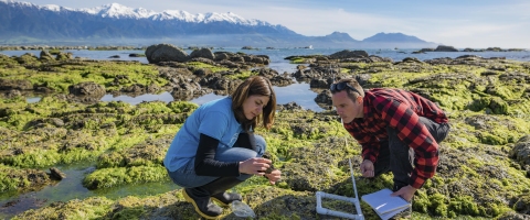
Marine biologists Dr Roberta D'Archino and Dr Leigh Tait are particularly interested in the intertidal reef, areas that were once covered in very high biomass are now almost bare. [Photo: Dave Allen, NIWA]
2 / 4

Rocky coastline lifted clear of the high water mark during the 2016 Kaikoura earthquake. [Photo: Dave Allen]
3 / 4

Rocky coastline lifted clear of the high water mark during the 2016 Kaikoura earthquake. [Photo: Dave Allen]
4 / 4

Marine biologists Dr Roberta D'Archino and Dr Leigh Tait checking rock pools in the intertidal reef. [Photo: Dave Allen, NIWA]
“We’ve got variable degrees of uplift along a large stretch of coastline,” says Tait.
“The wide-scale loss of habitat-forming species provides an important contrast to studies typically done in ecological disturbance experiments at the scale of metres. This disturbance happened across tens of kilometres.”
Tait is particularly interested in the intertidal reef, and the habitat-forming kelp species that have been affected by the uplift. A lot of these intertidal reefs have lifted by about half a metre. Very large areas of the reef that were underwater for approximately 50–60 per cent of the time are now under for less than 30 per cent of the time. Other areas were uplifted more than 6m, and now represent new terrestrial habitat.
Tait wants to assess how primary production has changed in communities that have been pushed into new tidal zones.
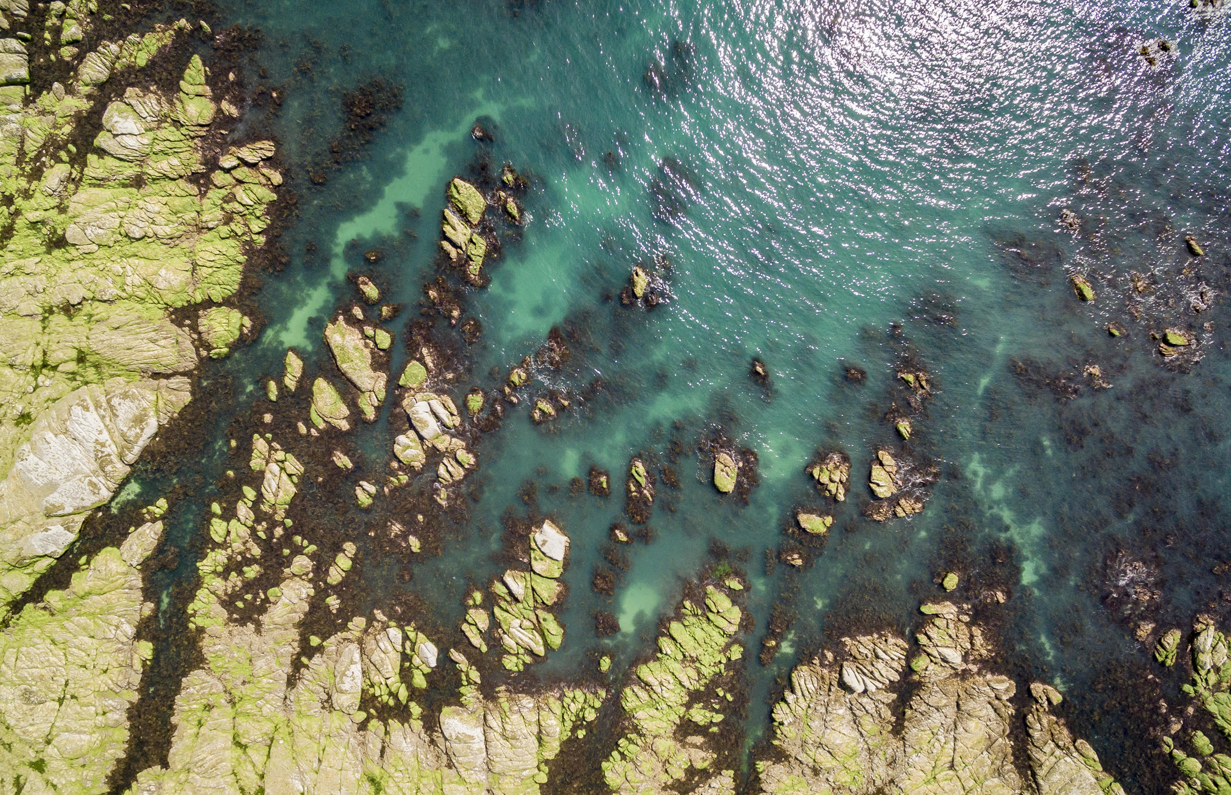
David Plew launches NIWA’s Altus LRX drone into the survey area, which captures a sequence of high-resolution images that will be used for habitat mapping. [Photo: Dave Allen, NIWA]
The drones are being used to take camera images. Previously, images would have been taken from fixed wing aeroplanes. As they can’t be flown very low to the ground, the images have to be taken from high altitudes. “What drones allow us to do is to take really high-resolution pictures at a much smaller scale,” says Tait.
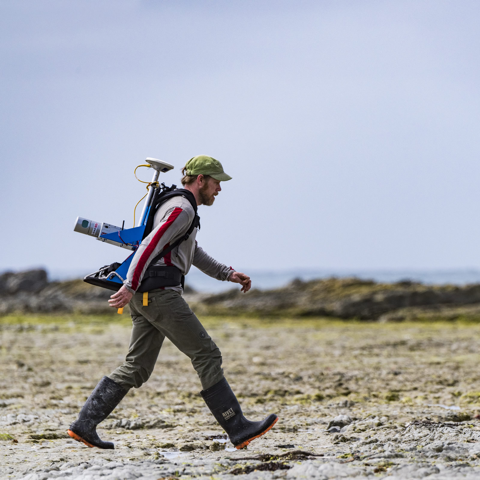
To do that, he is using state-of-the-art technology to conduct this research: drones and LiDAR.
LiDAR stands for light detection and ranging, and uses a spinning set of 32 lasers that bounce back and are read by the instrument. The LiDAR then works out the amount of bounce-back and provides a 3D image.
“With the LiDAR, we can get a 3D map of the reef area,” says Tait.
So far, the LiDAR has only been tested from a backpack mounted unit, but other applications have successfully been deployed using a drone.
Tait is using two drones in the field. One of these drones is large enough to lift the LiDAR – the frame of that one is about a square metre. The other drone is similar to the size of a recreational-type drone.
Tait, alongside drone pilot David Plew and LiDAR specialist Jochen Bind, has been running the drones over large portions of the affected area of rocky reefs and then doing the same with the LiDAR. “We can then stitch the two different sets of imagery together,” says Tait. Doing this allows the scientists to see how the wetted area of the rocky reefs has changed and get an idea of the area now available for re-colonisation by habitat-forming kelp species.
“These areas that were once covered in very high biomass have been lifted out of the water,” says Tait.
“In some places you’ve gone from having hectares essentially of reef area in a very habitable zone, to probably a tenth of that or maybe even less. That’s really what we’re trying to quantify with the drones and our LiDAR surveys.”
The project that Tait is conducting started in July 2017 and is part of the Innovation Fund of the Sustainable Seas National Science Challenge. “The Innovation Funds are meant for examining new technologies or ideas and how they might be used for the sustainable management of our marine environment,” says Tait. “So we’ve been trialling both sets of drones, but also trying to combine the data with a visual image sensor, so that we can overlay the three-dimensional structure with a habitat map of what’s actually down there.”

The hardest part of the research is getting the methodologies standardised. For example, coming up with colour-matching routines for identifying species, such as kelp and other macroalgal species, to be able to overlay imagery.
The imagery is stitched together using geo-referencing with ‘bull’s-eyes’ placed in the environment at different points that can be referenced by GPS. “Then we can pin the measured imagery to the targets,” says Tait.
“Once we’re happy with those images, the next stage is to extrapolate primary production of variously affected kelp and algal communities to meaningful scales,” says Tait.
While the Kaikoura earthquake may have been devastating, Tait recognises that it is a natural event that has presumably happened many times in the history of these coastlines. The difference is, these coastlines are now under a far different set of pressures than they were in pre-human times.
“Experiments like this can provide an assessment of how recovery of important habitats is affected by degrees of stress (uplift) and under these different regimes,” says Tait.