Climate developments in November 2007

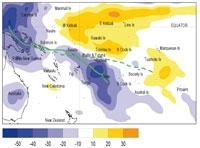
The South Pacific Convergence Zone (SPCZ) was very active, extending from the monsoon trough over Papua New Guinea toward the Solomon Islands, the region north of Fiji, and then southeast over Niue. The SPCZ was displaced further west than normal for the time of year, and further south in the region east of the Date Line. A horseshoe shaped region of suppressed convection continued to persist along the Equator, although not as far west as in October, affecting Kiribati, and the region further east (north of the Equator) to the coast of South America, as well as Tokelau and the Northern Cook Islands.
Rainfall was extremely high in areas under the active SPCZ with over 200% or more of normal in parts of Vanuatu, Niue, and Fiji, and also above normal in the Solomon Islands, much of Tonga, and the Southern Cook Islands. Heavy rainfall and flooding occurred in parts of Papua New Guinea during the month associated with tropical cyclone Guba. In contrast November rainfall was 50% or less of normal over much of Kiribati, New Caledonia, and northern French Polynesia, western areas of New Caledonia being extremely dry. Rainfall was near normal in most other regions.
Rainfall has been below average for each of the past six months in both Western and Eastern Kiribati, and above average for the past five months in Vanuatu.
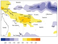
November mean air temperatures were about 1.0 ºC above normal in parts of Western Kiribati, the south of Vanuatu, southern Tonga, American Samoa, and the Southern Cook Islands, and about 0.5 ºC above normal in New Caledonia, Fiji, and Niue. Fiji was uncomfortably warm due to accompanying humid conditions.
Tropical Southwest Pacific mean sea-level pressures were below average over the Fiji-Tonga-Niue region. Higher than normal pressures occurred over the south Tasman Sea.
Equatorial surface easterlies remained persistent at Tarawa, occurring in about 95% of observations.
| Country | Location | Rainfall (mm) | % of average | Comments |
|---|---|---|---|---|
| Vanuatu | Lamap | 371 | 288 | Extremely high |
| Fiji | Nadi Airport | 325 | 246 | Record high |
| Fiji | Viwa Island | 400 | - | Record high |
| Fiji | Tokotoko | 666 | - | Record high |
| Niue | Hanan Airport | 607 | 349 | Extremely high |
| New Caledonia | Koumac | 1 | 2 | Extremely low |
| New Caledonia | La Tontouta | 3 | 5 | Extremely low |
Soil moisture in November 2007

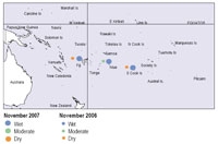
Estimates of soil moisture shown in the map (right) are based on monthly rainfall for one station in each country. Currently there are not many sites in the water balance model. It is planned to include more stations in the future.
The information displayed is based on a simple water balance technique to determine soil moisture levels. Addition of moisture to available water already in the soil comes from rainfall, and losses via evapotranspiration. Monthly rainfall and evapotranspiration are used to determine the soil moisture level and its changes.
Please note that these soil moisture calculations are made at the end of the month. For practical purposes, generalisations were made about the available water capacity of the soils at each site.
Formerly dry soils in Rarotonga (Southern Cook Islands) were relieved during November 2007, soil moisture being replenished by the end of the month. Soils continued to be at field capacity for the time of year at Hanan (Niue), and were also moist at Nadi (Fiji).
El Niño/Southern Oscillation (ENSO)


La Niña conditions have strengthened in the central and eastern Pacific, and are expected to persist into the Southern Hemisphere autumn. For the first month since the La Niña event began, the Southern Oscillation Index (SOI) has shown a strong movement upwards, showing ocean-atmosphere coupling.
Below normal sea surface temperature (SST) anomalies intensified across the tropical Pacific from South America to west of the Date Line during November, while a warm ‘horseshoe’ extends into the extratropics of both hemispheres. The NINO3anomaly was –1.6 °C for November (SON average –1.3 °C), while NINO4 strengthened to –0.8 °C (SON average –0.4 °C). Conversely, the subsurface temperature anomalies have weakened: the largest anomalies near 100 m depth over 140-120° W during November were about –2 °C (–4 °C in October).
The easterly trade winds were also strong and persistent during November over a wide longitude band centred on the Date Line. The SOI for November was +0.9 (+0.4 October), with the SON average of +0.5 (ASO average +0.1).
The trade winds remained enhanced both west and east of the Date Line.
Tropical OLR anomalies show suppressed convection in the equatorial region from the Date Line eastwards. Enhanced convection occurred over Indonesia, andthe South Pacific Convergence Zone is prominent through Fiji, south of its normal position. The TRMM-based ENSO precipitation index was –1.06 inNovember, entering the moderate range for the first time during the current event. The Madden-Julian Oscillation has displayed a fairly regular periodicity of 40–50 days in recent months, and the next active phase could begin around mid December, and precede monsoon development over northern Australia.
All dynamical models except Scripps, and all statistical models clearly indicate existing La Niña conditions. Most models indicate La Niña conditions continuing through the southern summer and autumn, before easing to neutral conditions in winter 2008. The NCEP synopsis (of 8 November) suggests La Niña is approaching moderate strength (Niño3.4 index below –1.0 °C), and likely to continue into early 2008. The IRI synthesis gives more than a 90% probability of La Niña conditions continuing through the next three months.
Forecast validation: September to November 2007
A La Niña-like pattern, with a large region of enhanced convection was expected from Vanuatu southeast to the Southern Cook Islands, with average or above average rainfall from Papua New Guinea eastsoutheast to the Southern Cook Islands, including Solomon Islands, Vanuatu, New Caledonia, Fiji, Samoa, Tonga, and Niue. Suppressed convection with average or below average rainfall was expected over Western and Eastern Kiribati, Tuvalu and the Northern Cook Islands.
The rainfall outlook for the September–November 2007 period was similar to what was forecast, the ‘hit’ rate being almost 80%.
Suppressed convection and below average rainfall occurred as expected in the equatorial region about and east of the Date Line, extending to Tuvalu, the Northern Cook Islands,and the Marquesas Islands. Rainfall was above average as expected from Papua New Guinea to Niue. Rainfall was higher than expected in the Society Islands, and lower than expected in the Marquesas Islands.
