Climate developments in October 2006

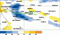
During October, a large region of enhanced convection occurred about and west of the Date Line, affecting Nauru, parts of Western Kiribati and the Solomon Islands, Vanuatu, Fiji, Tonga, and Niue. Some of this convection was due to tropical cyclone Xavier, which tracked south between Vanuatu and Fiji. The South Pacific Convergence Zone (SPCZ) was near its normal location, with some enhancement west of the Date Line. Convection was suppressed over much of Papua New Guinea, and was extremely suppressed further west over Indonesia.
Extremely high October rainfall occurred in parts of Western Kiribati (about 400% of normal at Tarawa). Rainfall was also above average (at least 125% of normal) over much of the Solomon Islands, Fiji, and Central French Polynesia. Rainfall was 50% or less than normal in the Southern Cook Islands and parts of Southern French Polynesia, and less than 25% of normal in parts of New Caledonia and Niue.
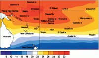
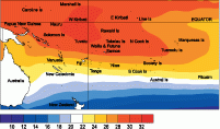
Mean air temperatures were 0.5°C or more below average in parts of New Caledonia, but were 0.5°C or more above average in parts of Central French Polynesia.
Tropical Southwest Pacific mean sea-level pressures were above average, over the south and east of Australia, with higher than normal pressures extending towards Papua New Guinea and to the south of Tonga. Pressures tended to be below average in equatorial areas east of the Date Line.
Equatorial surface westerlies occurred in about 45% of observations at Tarawa, the highest frequency since 59% during October 2002.
| Country | Location | Rainfall (mm) | % of average | Comments |
|---|---|---|---|---|
| Fiji | Monasavu | 794 | 241 | New record |
| Kiribati | Tarawa | 506 | 398 | New record |
| New Caledonia | Koumac | 4 | 13 | Extremely low |
| New Caledonia | La Tontouta | 5 | 11 | Extremely low |
| New Caledonia | Noumea | 9 | 18 | Well below normal |
| New Caledonia | Moue | 14 | 18 | Well below normal |
Soil moisture in October 2006

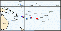
Estimates of soil moisture shown in the map (above) are based on monthly rainfall for one station in each country. Currently there are not many sites in the water balance model. It is planned to include more stations in the future.
The information displayed is based on a simple water balance technique to determine soil moisture levels. Addition of moisture to available water already in the soil comes from rainfall with losses via evapotranspiration. Monthly rainfall and evapotranspiration are used to determine the soil moisture level and its changes.
Please note that these soil moisture calculations are made at the end of the month. For practical purposes, generalisations were made about the available water capacity of the soils at each site.
At the end of October 2006, Tarawa was at field capacity (full) while Nadi and Nukualofa soils were at a moderate soil moisture level. Hanan and Rarotonga soil moisture levels were dry.
El Niño/Southern Oscillation (ENSO)


The tropical Pacific Ocean and atmosphere have developed into a clear El Niño state. Sea surface temperature anomalies have risen in the eastern Equatorial Pacific while negative anomalies have strengthened in the western Pacific and have begun to develop an extratropical "horse shoe" pattern in the subtropics.
The NINO3 anomaly rose slightly to +1.3°C in October, with NINO4 at +1.1°C (3-month means both just above +1°C). Accompanying this, positive zonal wind anomalies have intensified over the western Pacific and extended east of the Date Line for much of October.
Continued Kelvin wave propagation is evident along the Equatorial thermocline, with the latest 5-day average showing a strong thermocline depression in the central Pacific associated with a +4°C temperature anomaly at 150m depth.
The subsurface temperature average for October shows positive anomalies in the upper 100m everywhere east of 160°E. After a weak period in September, the Southern Oscillation Index (SOI) strengthened steadily in October, averaging -1.7 for the month.
OLR and tropical rainfall anomalies also reflect a more El Niño-like pattern, though there is still a considerable Madden-Julian Oscillation (MJO) component over the western Pacific, and the east-west dipole pattern usually associated with ENSO events is still displaced to the west, with strongly suppressed convection northwest of Australia and enhanced convection mostly between 150°E and the Date Line. An active MJO event passed through the Pacific and across the western hemisphere during October, but the MJO is now weak.
Most models show an El Niño state through to at least January, consistent with last month’s predictions. About half of the model predictions retain the El Niño into the southern hemisphere autumn 2007, but several predict an easing to neutral by April 2007.
The US International Research Institute (IRI) give an 80% chance of El Niño conditions continuing through the rest of the year, but note that some of their criteria for an El Niño event have not yet been met.
National Center for Environmental Prediction (NCEP) predict El Niño conditions persisting through early 2007.
