South Pacific Sea level and Climate Monitoring Project
Philip Hall, SPSCLCMP & Mary Power, SOPAC

The South Pacific Sea Level and Climate Monitoring Project (SPSLCMP) commenced in 1991 with the primary goal of generating an accurate record of variance in long-term sea level for the South Pacific and to establish methods to make these data readily available and usable by Pacific Island Countries (PICs). The project provides high quality data for use by the international scientific community and PICs to better understand the potential impacts of climate change and to plan adaptation responses across many sectors including the planning and development of coastal resources, management of fresh water resources, agriculture, fisheries, tourism and infrastructure. The SPSLCMP has entered its fourth phase, which commenced on 1 January 2006 and extends to 31 December 2010.
AusAID has engaged the Australian Bureau of Meteorology (BoMET) to provide overall project management and coordination for Phase IV. BoMET is working with its implementing partners Geoscience Australia (GA) and South Pacific Geoscience Commission (SOPAC), the National Meteorology Services (NMSs) and South Pacific Regional Environment Programme (SPREP) to strengthen relationships with regional stakeholders and to maintain the collective focus on the SPSLCMP’s primary purpose of sea level monitoring.
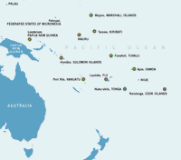
Phase IV will provide ongoing operation and maintenance of the existing 12 high resolution sea level (SEAFRAME) monitoring stations and 10 Continuous Global Positioning System (CGPS) sites located in the Cook Islands, Fiji, Federated States of Micronesia, Kiribati, Marshall Islands, Nauru, Papua New Guinea, Samoa, Solomon Islands, Tonga, Tuvalu and Vanuatu; install two CGPS stations deferred from Phase III (Solomon Islands and Marshall Islands); manage presentation and analysis of sea level data; and develop data products to meet the needs of stakeholders, especially the NMSs in the participating PICs.
Phase IV also incorporates some changes in administration and funding mechanisms. To ensure continuity of data collection, recurrent costs for communications and utilities associated with project sites will now be absorbed by the project rather than be borne by the participating PICs. PICs will continue to provide in-country support and facilities required by the network, such as providing access to associated land and infrastructure and performing "first-in" maintenance on behalf of BoMET, GA and SOPAC.
AusAID will undertake a strategic review of the Project in 2007 to ensure that the Project’s long term directions provide for long-term sustainability and are effectively aligned with other emerging regional climate activities and priorities. Extension of the network to include SEAFRAME and CGPS sites in Niue and Palau will be considered within the context of the strategic review.
The SPSLCMP is succeeding in its goal to provide an accurate continuous long-term record of sea level in the Pacific region for partner countries and the international scientific community that enables them to respond to and manage climate-related impacts
For more information contact:
Philip Hall Project Manager, SPSLCMP Email: [email protected] Web: www.bom.gov.au/pacificsealevel
Mary Power Manager Ocean and Islands Programme South Pacific Applied Geoscience Commission (SOPAC) Email: [email protected]
