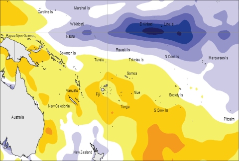
The tropical Pacific is now exhibiting moderate La Niña conditions, which may strengthen further over the coming few months.
There is good evidence of coupling between the atmosphere and ocean across the tropical Pacific. The atmospheric circulation exhibits suppressed convection near the Date Line and in both the ITCZ and SPCZ, while convection is enhanced over Indonesia. The SOI was near +2 on average for August (as in July; JJA mean +1.3), with enhanced trade winds over most of the Pacific, especially west of 170°W. The TRMM ENSO index has been near –2 (in the 30–day mean) for well over a month now (values of –1.0 or less are considered typical of La Niña conditions). Matching signals are evident in the ocean. A cold tongue extends along the Equator from the Date Line eastwards, with positive SST anomalies in the far west equatorial Pacific Ocean and in the extratropics (especially in the Southern Hemisphere). The NINO3 and NINO4 anomalies were both around –0.7°C on average in August (JJA averages of –0.5°C and –0.3°C, respectively). At the sub-surface, a strong negative heat content anomaly lies east of the Date Line, centred near 150°W and 100 m depth. A weak MJO convective pulse lies over the Indonesian region and is forecast to weaken further as it moves east.
All of the dynamical models NIWA monitor predict the tropical Pacific to be in a La Niña state over the coming 3–6 months, easing in early 2011. Statistical models mostly indicate the same evolution of NINO3.4 SST, but with lower amplitude. The NCEP ENSO discussion of 5 August states that La Niña conditions are likely to strengthen and persist through Austral summer 2010/11. NCEP forecasts a moderate-strong event. The IRI summary of 19 August indicates a >90% probability for La Niña conditions through the rest of 2010 (and 80-90% probability for early 2011).

Surface temperature anomalies (ºC) for August 2010
