El Niño/Southern Oscillation (ENSO)
The current El Niño event has weakened considerably, and the tropical Pacific is expected to return to a neutral state by the end of May 2010. Oceanic conditions have eased gradually and NINO3 and NINO4 anomalies were both around +0.9°C for April (three–month averages of +0.8°C and +1.0°C, respectively). Upper–ocean equatorial heat content is now mostly negative, apart from the near-surface in the far eastern Pacific Ocean. In the atmosphere, recent changes have been more abrupt. The Southern Oscillation Index (SOI) rose to +1.7 in April (from below –1.0 in March), the first significant positive value for the monthly SOI for a year. The 3-month mean SOI was –0.5 at the end of April. Tropical outgoing longwave radiation last month showed enhanced convection over Indonesia and northern Australia and a north–south banded structure farther east, suggestive of an enhanced ITCZ in the NH and generally suppressed convection between the Equator and 15°S. Consistent with this pattern, the 30–day mean TRMM ENSO index was +0.1 in late April (values of +1.0 or more are typical of El Niño conditions). The trade winds were generally a little stronger than normal in April across most of the Equatorial Pacific, The MJO is very weak at present, but a convective pulse may develop during early May.
All the models NIWA monitor show ENSO–neutral conditions for the next 3 months, and about half the available models suggest development of a La Niña by austral spring 2010. The NCEP ENSO discussion of 8 April suggests ENSO-neutral conditions will be reached by mid–year. The IRI summary of 15 April indicates El Niño dissipation followed by a 35% chance of La Niña in late 2010.

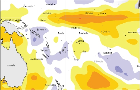
Sea surface temperature anomalies (ºC) for May 2010
