On this page:
Download a shorter version of this lesson in PowerPoint or as a PDF or continue below to see the lesson in full.
The climate of New Zealand is incredibly varied for a country of its size. The warm, sunny beaches and lush forests of Northland contrast sharply with the snow-capped Southern Alps and hot, dry tussock fields of Canterbury and Otago. In this lesson, we’ll learn why New Zealand’s climate varies so much.
Aotearoa has a relatively wet, mild and windy climate.
There are four pieces of the puzzle that are important for understanding New Zealand’s climate:
Aotearoa’s temperate latitude
Climate varies around the world. The latitude of a place, or how far it is from the equator, influences the type of climate a place experiences. Close to the equator, in the tropics, the climate is generally very warm and humid, with lots of rainfall. Further away from the equator, at the poles, the climate is generally very cold and snowy.
New Zealand sits about halfway between the equator and the South Pole, which means we have what’s known as a temperate climate. This means our climate is more likely to experience moderate conditions (rather than the extreme heat or cold of the tropics or the poles!).
The influence of the ocean
The ocean surrounding New Zealand causes more moisture to be held in the air that travels across the country, bringing quite humid conditions and rainfall year-round. These oceanic airmasses cause temperatures to generally be quite moderate (not extremely hot or cold), and our daily and seasonal temperature range is often more muted than in continental locations (although there are exceptions to this as you’ll see later!).
Because New Zealand is surrounded by ocean, sea breezes ease temperatures and can cause cloudy weather to dominate. In contrast, think about the very different climates of places that are far from the ocean, for example the hot, dry deserts of Australia and the long, cold winters of Siberia.
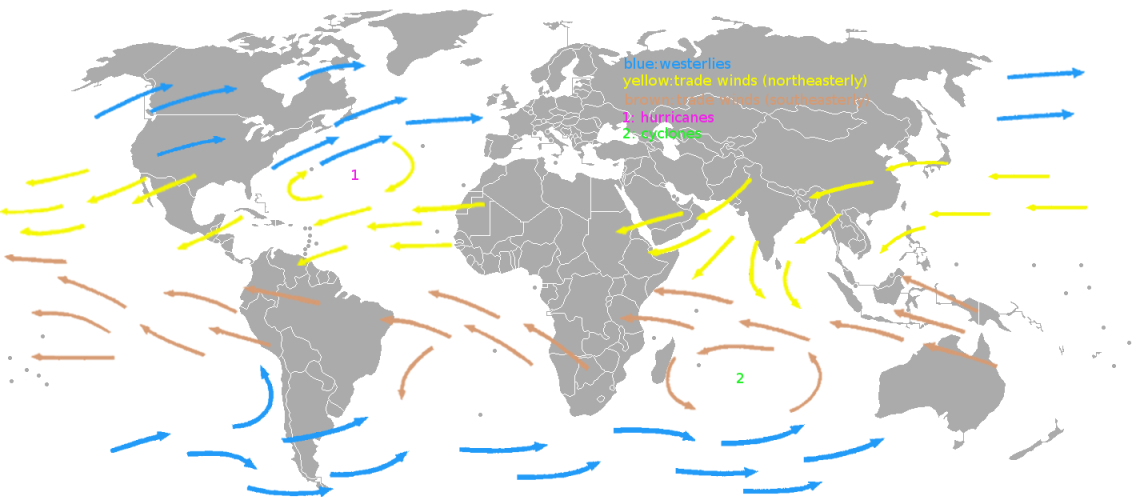
Prevailing westerly winds
Because of New Zealand’s position in the temperate (middle) latitudes of the Southern Hemisphere, the prevailing (most common) wind direction is from the west to the east. This means that weather systems (movement of warm and cold air) are generally pushed from west to east as well.
In the Southern Hemisphere, there is not much land to slow down the westerly winds, compared with the Northern Hemisphere where there are large areas of land to slow down the winds. The strongest westerly winds that occur in the middle latitudes of the globe are called the Roaring Forties. Remember that New Zealand lies in the middle latitudes putting usin the middle of the Roaring Forties!
Westerly winds bring air full of moisture towards the west coast of New Zealand, partly explaining why western areas are usually wetter than eastern areas. For the remaining part of the puzzle, we need to understand more about New Zealand’s topography and how that affects our climate.
New Zealand’s varied topography (the shape of the land)
The landscape and topography (shape of the land) of New Zealand is hugely varied. This causes our climate to be quite different from place to place.
Mountains have a huge influence on Aotearoa’s climate. The way that most of our mountain ranges, such as the Southern Alps, run roughly northeast to southwest really influences climate patterns across the country.
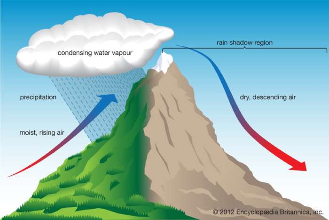
Remember the prevailing westerly winds we just learnt about? When these winds, carrying lots of moisture, reach the west coast of New Zealand, they are forced to travel up the side of the mountain because the mountains are blocking their path.
This is where we get an effect called orographic rainfall. This means that as the air rises and cools, clouds form and rain (or snow if it’s cold enough) falls. Most of the rain falls upwind ( on the western side) of the mountain range and the downwind side (eastern side) of the mountain range is in what’s called the rain shadow where only small amounts of rain fall You can see this in the diagram below.
This is why we get very high rainfall on the west coast of the South Island in places like Milford Sound (almost 7 metres of rainfall a year!) but only about 100 km away, Central Otago is in the rain shadow area, and places like Alexandra only get on average 30 cm of rainfall a year. How crazy is that?!
Climate overview
Now we know about the four main factors, or pieces of the puzzle, that influence the climate of New Zealand.
Let's have a look at some maps below where we can see the effect of these factors.
The map to the right shows New Zealand’s annual rainfall patterns – what we would expect per year when averaged over a 30-year period.
What do you notice? You can see that the west coast of the South Island gets the most rain while the rain shadow area to the east of the Southern Alps is the driest part of the country.
You can see a similar effect happening in the North Island where more rain falls in western areas and there is a rain shadow in regions like Hawke’s Bay and the Wairarapa.
The orographic effect is much smaller here than down south due to the mountains being lower.
Northern parts of the country get much of their rainfall from passing storms and ex-tropical cyclones which can be a significant source of rainfall for areas like Northland, the Coromandel Peninsula, and Gisborne.
But what about temperature?
Because New Zealand is such a long country, our average temperature varies quite a lot from north to south.
You can see on the map to the right the warmest part of the country is the northern tip of Northland.
The coldest areas are in the highest parts of the Southern Alps around Aoraki/Mt Cook. It’s also pretty chilly on average in Southland and Otago.
As mentioned earlier, there are some exceptions to our generally moderate temperature patterns.
The inland parts of Otago and Canterbury are far from the ocean and in the rain shadow, so these areas can be quite dry and have a much larger daily and seasonal range of temperatures – typically these areas are where we have recorded both our hottest and coldest temperatures!
If you'd like to learn more, check out the below web pages:
Activity - create a climate graph
Create a climate graph of two different locations in New Zealand and see how their rainfall and temperature changes throughout the year.
What you’ll need:
- A computer with MS Excel
OR
- A pencil
- A blue pencil
- A red pencil
- A ruler
- A piece of graph paper
Instructions:
- Download the monthly average temperature and rainfall data and choose two locations that you’re interested in. It’s best to choose locations that are quite far from each other so you can make a good comparison – for example Auckland and Christchurch, or Westport and Napier.
- Copy the data into a separate spreadsheet.
- If you’re going to create the graph on a piece of paper, watch the ‘manual graph steps’ video here. If you’re going to create the graph in Excel, watch the ‘Excel graph steps’ video here.
- Compare the two climate graphs you have made for the locations – how are they different? How much does temperature and rainfall vary throughout the year at the two sites? Can you think of any reasons why the rainfall and temperature might be different, based on what you’ve learned in this lesson?
Quiz – climate of Aotearoa
Check out our climate of Aotearoa quiz. The quiz works best on Kahoot, but if you prefer a text version, you can download it as a PDF.


