The Southwest Pacific Climate in 2004
Stuart Burgess & Dr Jim Salinger, NIWA
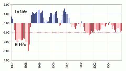
In 2004, the El Niño/Southern Oscillation (ENSO) conditions evolved from a neutral state in the first half of the year to a weak El Niño event in the central equatorial Pacific in the second half of the year (Figure 1). The trade winds were near normal in strength at the start of the year, but equatorial westerly wind bursts occurred, often reaching the Date Line, from June onwards. Apart from these (and warmer temperatures for many), the El Niño had little impact on the climate of most Southwest Pacific Islands. However, much of New Caledonia and Vanuatu, and to a lesser extent, Fiji and Tonga, had several drier than normal months toward the end of the year.
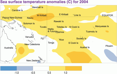
The weak El Niño event was expressed more definitely in sea surface temperature (SST) anomalies. Above average SSTs occurred throughout the region during 2004 (Figure 2), being at least 1.0 °C above average around Western Kiribati, and 0.5 to 0.9 °C above average in many other island nations, especially those east of the Date Line. New Caledonia, Vanuatu, the main island of Fiji, and Tonga, were surrounded by near average SSTs.
As with SSTs, air temperatures were 0.5 °C or more above average throughout much of the tropical Southwest Pacific in 2004, especially along the equator from Nauru to Western Kiribati where they were about 1.0 °C above average. Air temperatures were near average in many areas southwest of the Date Line, including Vanuatu, New Caledonia, and parts of Fiji. The year was one of the warmest on record for mean air temperature at Fua'amotu Airport in Southern Tonga (+0.7 °C above average).
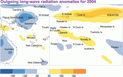
For much of the year, from April onwards, mean sea level pressures were generally above average west of the Date Line, and below average in the east. Areas of enhanced convection affected the region about and north of the Solomon Islands, and also Pitcairn Island, while suppressed convection occurred along the equator about and east of the Date Line (Figure 3). West of the Date Line, the South Pacific Convergence Zone (SPCZ) was a little further north and east than usual, especially during the first six months. East of the Date Line, the SPCZ was further north and east than usual during the first four months, after which it then lay south of its normal location, with slightly suppressed convection over Samoa and the Society Islands, which is at variance with the normal ENSO climate response.
This pattern affected the year’s rainfall distribution, with rainfall being at least 110% of average over much of the Solomon Islands, Tonga, Niue, and parts of Tuvalu, and more than 150% of average in the Marquesas Islands of northern French Polynesia as well as Pitcairn Island. Rainfall was less than 80% of average in parts of New Caledonia, and less than 90% of average in Fiji’s Western Division, parts of Samoa, and the Society Islands of central French Polynesia. Rainfall was near normal elsewhere.
Four tropical cyclone occurrences affected the region in the January – April 2004 period, two of which were classified as major hurricanes.
| Country | Location | Rainfall (mm) | % of average | Comments |
|---|---|---|---|---|
| New Caledonia | Belep | 1054 | 59 | Extremely low |
| Tuvalu | Nanumea | 4154 | 139 | Well above average |


