RV Tangaroa voyage update
Our team of NIWA experts continue to map the seafloor on the deep northern and western slopes of the Hunga Tonga - Hunga Ha’apai volcano (HT-HH), with the aim of identifying areas of morphological change of the seafloor caused by the January 15th eruption.
21 April 2022
By 8 a.m., RV Tangaroa had arrived at the next site, located 20 km south-west of the HT-HH vent and lying at a depth of 1700 m. Our aim was to survey the ash thickness and distribution in that area, to better understand how the recent eruption affected the seafloor.
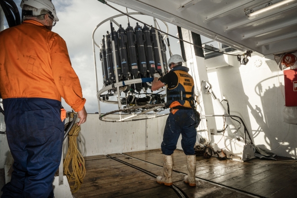
First, a CTD probe with water sampling rosette bottles was deployed to measure the temperature, conductivity (salinity), chlorophyll and dissolved oxygen present in the water from the surface to the seafloor. These CTD casts and water samples are being used to build an understanding of the ocean conditions around the volcano. The rosette bottles sampled water from several specific depths to measure the levels of trace metals in the different layers of the sea water using a special clean lab on board the vessel. Trace metals are contained in ash from eruptions of volcanos and, depending on the amount, can either be nutritious or toxic for ocean life.
The Deep Towed Imaging System showed images of a very similar scene as the other sites: flat fine sand with very little life. However, attempts to get core samples from this site proved difficult. Unlike other sites so far, the seafloor material was much coarser, and it took three attempts with the multicorer to get enough samples to do the analysis.
Overnight, the Tangaroa continued its multibeam mapping around the western flanks of HT-HH and undertook another CTD with water sampling rosette bottles on the northern flank in 1,260 m of water.
We are currently mapping the seafloor while making our way to the next site, where we will continue the ash thickness gradient mapping.
In the media
Check out this story featuring some of the footage shot during this voyage: Kiwi scientists investigate impacts of Tonga eruption (1news.co.nz)


