NIWA discusses this year's most asked question—what is happening to our fresh waterways?
No one in New Zealand is far from a river. This year, the most asked question is whether those rivers are swimmable.
This question has been part of what the Prime Minister’s Chief Science Advisor, Sir Peter Gluckman, calls “a complex and at times confusing public discourse about freshwater.”
One problem is that the swimmable quality of water is not the only, nor the best, measure of water quality. Many of the more than 1000 waterways monitored by NIWA and regional authorities are degraded by human activity in many ways other than water borne pathogens such as strains of Escherichia coli (E. coli).
The type of degradation varies widely and wildly, depending on how people use land and how water drains to the river. In places, water is contaminated with sediment or nutrients. In others, there’s chemical toxins. In still others, the water flow is altered, channel straightened and river routes modified. Some of these things affect human safety. All of them affect the habitat of hundreds of species of fish, invertebrates and plants.
Gluckman says the “inevitable” human impacts, and the physical, chemical and biological characteristics, of fresh water are so great that “No single measure is sufficient to understand the state of freshwater.”
Gluckman says there is no choice but to have “nuanced definitions [of water quality] that take into account what is an acceptable risk, consideration of the seasonal changes, (and) the relationship to extreme weather events.”
The challenge to politicians and the public, to scientists and environmental and industry advocates is that the impacts of such complexity must be interpreted and communicated clearly.
This story starts to answer Sir Peter’s challenge by identifying the myriad of ways we all contribute to degrading our waterways, and some of the solutions we can be part of. NIWA’s Freshwater and Estuaries team is led by Chief Scientist Dr John Quinn. New Zealand’s longest river, the Waikato, flows past his Hamilton home on its journey from the clear upper reaches near Taupo to murky lowland.
Quinn says debate over the Waikato is a microcosm of the nation’s struggle with water quality.
“People want healthy rivers and lakes they can be proud of—where they can swim and fish safely and know that ecological health is good. But many no longer meet the mark because of the way we have used the land and engineered rivers. Reversing this is challenging because society also values the things that put pressure on our freshwater. No one is removing the hydro-dams that interfere with flow of sediment, fish and water, but also generate clean and renewable energy, help to manage flooding, and provide a world-class rowing lake. We’re not removing the roads and paved cities that flood rivers with contaminated storm water. We’re not closing down agriculture, but we do expect lower footprint farming systems. Can we really expect to be able to have our cake and eat it too?”
The Waikato River drives nine hydro-power stations. It carries waste from 80 direct discharges such as treated town sewage, treated waste from factories, and 1600 smaller discharges into tributaries, and runoff from more than 2000 dairy farms in the Waikato and Waipa catchment.
|
The quality of the Waikato River has been a concern for many decades. Impetus to do something about it came with the settlement of Waikato-Tainui’s claim for the river and the iwi-Crown agreed Vision and Strategy that sets out an aspiration for its improved health.
The river has been witness to a large regional effort to reduce damage to waterways. Direct sewage discharge from Taupo township was stopped in 1995. Two-thirds of dairy farms have switched to land treatment of dairy effluent. It has been estimated that the Waikato River Authority has put $60 million into 170 restoration projects, including a million native trees planted along the river and its tributaries.
Quinn says “The real question is how to fix things so waterways can sustain what we want from them now.”
Quinn’s team took on the boldest attempt so far in New Zealand to test how well a river meets everything expected of it. Last year, NIWA worked with the Waikato River Raupatu Trust to compile a “report card” on the Waikato River for the Waikato River Authority. Thirty subject experts from 10 organisations combined science with the views and knowledge of community interests to give the river catchment a C+ grade.
This was the average of the scores given to specific stretches of the river and its tributaries and lakes. The grades reflected measurements across eight different indicators: water quality, water security, economy, kai (food), ecological integrity, experience, effort and sites of significance.
“We regarded this a low grade, because it fell significantly short of people’s expectations of a healthy river,” Quinn says.
What is water quality?Water quality refers to the physical, chemical and biological characteristics of a water body. These determine how and for what purpose water can be used, and the species and ecosystem processes it can support. Factors measured include pH, dissolved oxygen, suspended sediment, nutrients, heavy metals and pesticides. Quality measurements can also include key biological and biochemical variables, such as invertebrate and fish composition, the abundance of algae, and oxygen demand. These provide broader measures of ecosystem health. Multiple measurement variables are used in virtually all assessments of water quality, creating a rich picture of the state of the water. In an attempt to rank sites and simplify communication, composite indices of water quality have been developed. While these indices can have their uses, they are problematic and can disguise specific problems within a waterbody. |
The murky big picture
Quinn believes the recent focus on what is “swimmable” disguises the complexity of the problem and its solution.
“Being swimmable is not a great measure of a river’s overall health or quality. You can swim at Lake Ohakuri, for example, but it has lost its koura and has high mercury and arsenic levels in its sediments.
“Pathogens, indicated by E. coli, may directly hurt people, but there’s a whole lot more human activity that’s damaging flora and fauna. Aside from water quality, the four biggest pressures on water ecosystems are stress caused by invasive species like hornwort and koi carp, loss of natural connectivity due to barriers we’ve built along our rivers, flow and water level changes and riparian habitat damage.”
The breadth of NIWA’s work on freshwater gives an indication of the complexity and range of human impact. For example, teams of scientists are working on ways to treat human wastewater in towns and on farms, installing fish passages in channelled waterways, reducing the flood of rain channelled by urban and road stormwater, calculating downstream impacts of water take, building wetlands and riparian strips to stop nutrients washing from farms, and halting the degradation of lakes by invasive exotic plants and fish, nutrients and fine sediment.
Good old days?
Is freshwater quality getting better or worse? The trends are mixed in data published for the period from 2004 to 2013.
“There’s general improvement for contaminants like E. coli that get into water from surface runoff and stock in streams. There’s between one-half and almost two times more sites that have improved over the last decade rather than degraded in E. coli, ammonium, clarity and dissolved phosphorus,” says Quinn.
“Yet there are more streams deteriorating than improving in nitrate levels, which mainly travels via groundwater. There are 55% more sites with rising nitrate levels than those with improvements.”
Quinn says people’s recollections are often correct, but they sometimes have rose-tinted glasses when they compare rivers of their past with the current situation.
“Forty to 50 years ago a lot of rivers had serious pollution from very poorly treated point source sewage and industrial discharges. These are now largely cleaned up. When I studied the Manawatu River in the 1980s it had regular blooms of ‘sewage fungus’ and fish kills due to very low oxygen levels. The river was polluted by crudely treated sewage, and effluent from dairy and meat works. Back then people were not aware of cyanobacterial mats on the river bed, though they existed. Today, those things would generate bathing warnings and newspaper headlines.”
Testing waters
With so many rivers, streams, lakes and wetlands, knowing exactly what is going on is a massive challenge.
Collectively, New Zealand’s regional councils, unitary authorities and NIWA monitor more than 1000 river reaches and approximately 80 lakes. Data is periodically aggregated and analysed for national scale assessments of river and lake state and trends. All the sites are monitored for water quality and biology either monthly, seasonally or annually. Water quality is notoriously variable. NIWA environmental chemist Dr Neale Hudson says the fact that waterways are not monitored more regularly creates “a lot of holes in our nation’s cheese”.
“We’re missing a lot of what is going on in the waterways between sampling occasions and between sampling locations.”
However, Hudson says NIWA has cracked the practical and scientific challenges of continuous water quality monitoring. Equipment has been converted to battery power and upgraded to communicate data and status by cellphone. Measuring protocols have been created to guide where equipment is placed, and for how long, to ensure accurate readings.
“No stretch of water is the same at any one time—making water measuring a complex business. But we’ve built systems that provide a lot of confidence in the results,” Hudson says.
If it’s not feasible to measure water quality everywhere, what do we do about the water quality in places where we aren’t sampling? Linking predictive models, built from national monitoring, and the River Environment Classification has enabled a new approach to filling the spatial gaps in coverage of freshwater information between monitoring points, says NIWA environmental modeller Dr Doug Booker.
NIWA has recently released a free app—NZ River Maps—that uses these model predictions to show patterns across New Zealand’s rivers in about 100 attributes covering hydrology, water quality, fish distributions, invertebrate metrics, suspended and deposited sediment and fish and bird habitat.
A river networkNIWA runs the National River Water Quality Network (NRWQN)—a network of 77 sites on 35 rivers that are evenly distributed over the two main islands of New Zealand. The NRWQN river catchments together drain about half of New Zealand’s total land area. Sites were selected so that a national perspective of state and trends of water quality could be developed. On most rivers there are two or more sites representing an upstream “Baseline” site (lightly impacted) and a downstream “Impact” site (reflecting the impacts of humans on water quality). 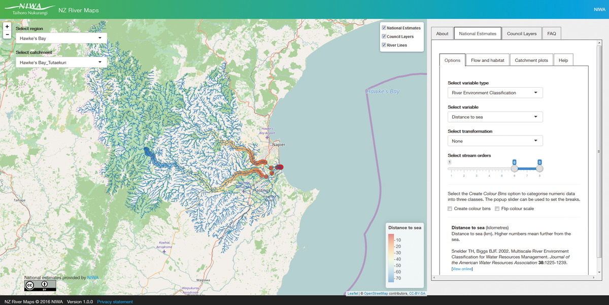
|
No more assumptions
Dr Scott Larned, NIWA’s Manager of Freshwater Research, is looking even further ahead to understand the ecological processes that muddy the picture of our human impact.
“You can’t fit a river inside a test tube. We can’t yet run tests that replicate everything that happens in a river, and how that changes moment to moment.”
A recent paper by NIWA scientists analysed streams from which dairy stock were excluded by fencing. Even where stock had been excluded for years, positive responses in aquatic communities were generally weak.
“It’s common sense that exclusion stops direct waste input and habitat destruction by livestock. However, some sediment and nutrients still get into rivers in other ways. The legacy of decades of erosion, fertiliser and pesticide use, urban development and other activities may take decades to clear. The sensitive species that have been lost need to recolonise and compete with the tolerant, weedy species that have moved in—so ecological recovery can lag behind improvements in water quality and habitat. The links between specific activities and ecological conditions in freshwater are often unclear. There’s a shortage of cause-and-effect relationships. Those relationships are needed to predict effects of future activities, including restoration. They provide evidence for making land management recommendations.”
Larned thinks timeframes for improving water quality can be shortened by moving from assumptions about human impact on land cover (bush, plantation forest, pastoral and urban) to measurement of specific activities on each block of land.
“When we link what we see in the water to exactly what we’re doing on land we will get much better at understanding water quality problems and how to reduce and prevent them.”
A new measure of water
Quinn thinks the “swimmable” test is the first in a series of measurements that will become familiar to the public.
“Water is too critical to our lives to be satisfied by superficial questions and simplistic answers. You cannot use one measure to determine the state of a very complex system.
“It’s all connected. That creates deep issues we’re just unravelling. But it means that every action we take can have multiple benefits, if we are strategic. We’ve got to consider multiple things in the water, and the habitat around it.”
He says this more holistic view of the health of our freshwaters needs to include measurements of ecotoxicity, clarity, nitrogen and phosphorus levels, flow regimes, economic uses, ecosystem services, cultural values and the health of plant, insect and fish populations.
“We all impact on fresh water. There will be hundreds of fixes required, and each of us will need to be involved”
He predicts the measurements will be used by communities doing their own versions of the Waikato River report card.
“The report card method identifies and balances all our uses—economic, environmental and cultural,” Quinn says. “We cannot pin blame and remedial work on just one section of society. We all impact on fresh water. There will be hundreds of fixes required, and each of us will need to be involved.”
Water everywhereNew Zealand has one of the highest volumes of water per capita flowing to the sea through some of the shortest waterways in the world, over the course of days rather than months (unless dammed). The flow rate changes dramatically due to rain, and the water often passes through an extreme range of geography—from mountain, bush, forest, pasture and towns. And there are other complications—water is not uniformly spread and much of it is in places where people are few (like the West Coast), flows are highly variable over time and predicted to get more so with climate change, and water that is available for use after allowing for environmental values is often fully-allocated (sometimes over-allocated) in the drier regions of the east coasts of both islands and Northland. About half of New Zealand’s river length is fed by water coming from largely indigenous land cover, while 45.7% comes from pasture land, 5.1% by exotic forest and 0.8% by urban land cover. |
About 200 NIWA staff have expertise in freshwater
For further study
Map on swimmable locations.
[This feature appeared in Water & Atmosphere 18]
Next article on Stepping into the river: Dairy turns the corner

