A weekly update describing soil moisture across the country to help assess whether severely to extremely dry conditions are occurring or imminent. Regions experiencing these soil moisture deficits are deemed “hotspots”. Persistent hotspot regions have the potential to develop into drought.
Soil Moisture
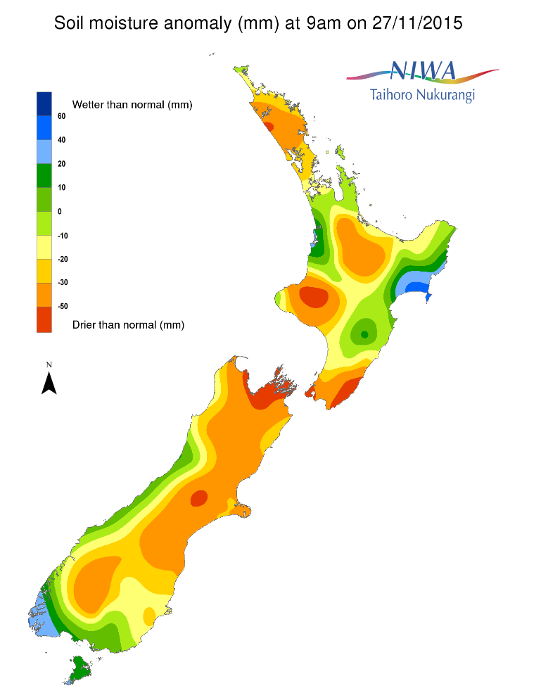
Soil moisture levels across the North Island have remained largely unchanged when compared to this time last week. Soils in the Wairarapa are still considered to be severely drier than normal for this time of year, while soil moisture in the Bay of Plenty and Northland regions is also drier than normal. Soil moisture levels in the Taranaki region are well below normal for the time of year but as this region typically receives abundant rainfall the storage levels of the soil are still adequate despite the decrease in soil moisture. Soil moisture levels in southern Gisborne and northern Hawke’s Bay have decreased when compared to this time last week. However, they remain in the near normal to slightly above normal range.
Soil moisture levels in the South Island are also similar to this time last week. These levels are below normal for virtually the entire South Island with the exception of coastal portions of the West Coast, Southland and southern Otago. Severely to extremely drier than normal soils for this time of year exist in eastern Marlborough, central Canterbury and about the Mackenzie District.
Outlook
For the North Island, showers associated with a cold front will make their way across the island on Sunday and into early Monday for northern areas. Outside of the threat for locally moderate falls (10-15+ mm for the lower parts of the island Sunday morning and again over Northland Sunday night into Monday morning) rainfall will be generally light. Thereafter, high pressure will largely dominate, resulting in generally settled and dry weather. Soil moisture levels across much of the North Island are expected to decrease as a result.
For the South Island, a cold front will bring rain (and even high elevation snow) across the entire island on Saturday and Sunday morning for northern areas. This will bring some reprieve for the driest locations in the north and east of the island. However, this will be short lived as high pressure brings dry conditions through to mid-week. By Thursday another frontal band brings the promise of rain but at this stage it looks like it will be contained west of the Divide. As a result it is likely that soil moisture levels across most of South Island, particularly east of the Divide, will decrease over the next 7 days.
Overall, a hotspot persists in the Wairarapa region of the North Island. In the South Island, hotspots exist in eastern Canterbury and parts of Central Otago, as well as eastern Marlborough.
Background
Hotspot Watch a weekly advisory service for New Zealand media. It provides soil moisture and precipitation measurements around the country to help assess whether extremely dry conditions are imminent.
Soil moisture deficit
The amount of water needed to bring the soil moisture content back to field capacity, which is the maximum amount of water the soil can hold.
Soil moisture anomaly
The difference between the historical normal soil moisture deficit (or surplus) for a given time of year and actual soil moisture deficits.
Dry and extremely dry soil
Definitions: “Extremely” and “severely” dry soils are based on a combination of the current soil moisture status and the difference from normal soil moisture.
Check out NIWA's soil moisture maps
Soil moisture anomaly maps
Pictured below are soil Moisture Anomaly Maps, relative to this time of year. The maps show soil moisture anomaly for the past two weeks.