A weekly update describing soil moisture across the country to help assess whether severely to extremely dry conditions are occurring or imminent. Regions experiencing these soil moisture deficits are deemed “hotspots”. Persistent hotspot regions have the potential to develop into drought.
Soil Moisture
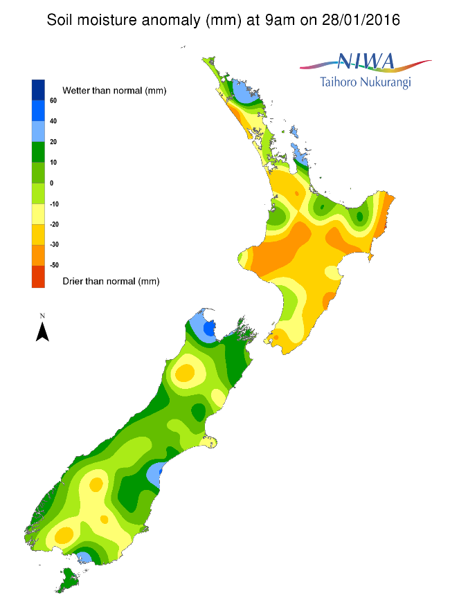
Soil moisture levels across the North Island have generally increased or remained the same when compared to this time last week. The most significant increases were observed over northern Hawke’s Bay, Gisborne and into the southern Bay of Plenty where ex-tropical cyclone Victor dropped heavy rains late last week. The other exceptions are across the tip of the north and in the Wellington region, where soil moisture decreased. Currently, central Waikato, much of Taranaki and Manawatu-Whanganui, and Wellington have below normal soil moisture for this time of the year. Soil moisture is near or above normal in eastern Northland, southwest and northern Waikato, eastern Bay of Plenty, Gisborne, and Hawke’s Bay.
Across the South Island, soil moisture levels have generally remained the same or decreased over the last week. The most dramatic decreases were found across the northern West Coast into southern Tasman and across Southland and interior Otago. Soil moisture levels remain near or above normal for much of Canterbury, Marlborough, Nelson and northern coastal Tasman. Near normal or below normal soil moisture levels for this time of the year are found elsewhere.
Outlook
For the North Island, after steady, soaking rains push from Northland to Auckland on Friday and also affect Waikato, the Bay of Plenty and the Central Plateau to a lesser degree, rainfall will be more scattered in nature on Saturday. A locally drenching shower or thunderstorm may form just about anywhere from Taranaki east to Hawke’s Bay to Northland on Saturday afternoon as a moisture-rich Tasman low swirls to the north of the country. While rainfall will generally be less than 5 mm in most locations across the aforementioned regions, isolated locales may see upwards of 15 mm. Sunday, a drier southeasterly flow regime will set in, allowing for a mostly rain-free day for the North Island. The early, stray shower (less than 5 mm) cannot be ruled out from the Coromandel Peninsula to Northland while a steadier rain (5-15 mm) affects Hawke’s Bay and Gisborne to east coastal Manawatu-Whanganui.
Generally, the North Island looks to be on the dry side for Waitangi Day save for the rogue shower across the north and persistent light rain or drizzle from interior Hawke’s Bay to Gisborne. Tuesday and Wednesday also look chiefly dry across the North Island, though a few afternoon and evening showers are liable to pop up from the Central Plateau to Northland. No organized storms are expected for the end of next week, so aside from daily isolated shower activity central and north, dry weather is expected. A corridor from southern Manawatu-Whanganui into Wellington has the potential to be entirely rain-free for the next week or so.
On the South Island, a southerly change from Southland to the east coast will give some light rain on Saturday. Rainfall totals are likely to be less than 5 mm for Southland but 5-15 mm across interior Canterbury. Sunday and Monday are expected to be largely dry across the South Island with high pressure in control. A southerly change on Tuesday will usher some moisture northward from Southland to mid-Canterbury with light, scattered rains persisting into Wednesday. A few disturbances late next week may bring scattered rainfall to the southern and central portion of the South Island northward through the Alps. The far northern portion of the South Island, including coastal Tasman, Nelson and Marlborough has the potential to be mostly dry over the next week.
Soil moisture
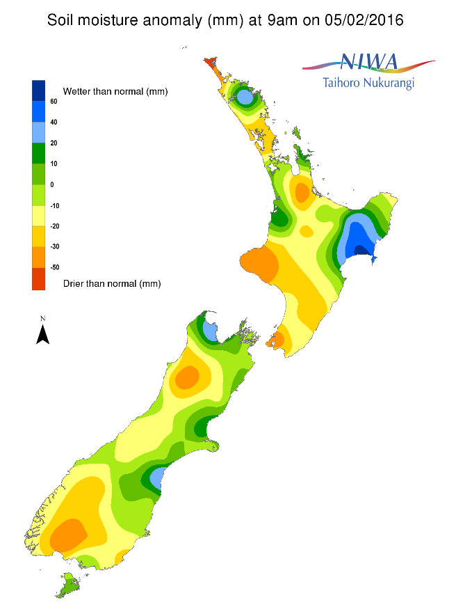
For the North Island, hotspot areas are present in extreme northern Northland, northern Auckland, and central Waikato, much of Taranaki, interior Manawatu-Whanganui, and southern Wellington. Rain across Northland, Auckland and into Waikato and interior Taranaki from Friday into Saturday will help to reduce or eliminate hotspot coverage. Scattered rainfall across the northern North Island over the course of the next week means that additional hotspot development is not expected there. On the contrary, abnormally dry weather from southern Manawatu-Whanganui into Wellington will favour hotspot expansion.
Hotspot areas remain present across interior Southland and interior Otago on the South Island. Rainfall across these regions will be minimal over the next 5 to 7 days, likely promoting hotspot expansion. Hotspot development is now being monitored across interior Tasman and along the northern West Coast. Largely dry conditions in these regions may favour hotspot development over the next week.
Background
Hotspot Watch
Hotspot watch is a weekly advisory service for New Zealand media. It provides soil moisture and precipitation measurements around the country to help assess whether extremely dry conditions are imminent.
Soil moisture deficit
Soil moisture deficit is the amount of water needed to bring the soil moisture content back to field capacity, which is the maximum amount of water the soil can hold.
Soil moisture anomaly
Soil moisture anomaly is the difference between the historical normal soil moisture deficit (or surplus) for a given time of year and actual soil moisture deficits.
Definitions
“Extremely” and “severely” dry soils are based on a combination of the current soil moisture status and the difference from normal soil moisture.
View NIWA’s drought indicator maps
Soil moisture anomaly maps
Pictured below are soil Moisture Anomaly Maps, relative to this time of year. The maps show soil moisture anomaly for the past two weeks.