Weekly update to help media assess likelihood of extremely dry weather preceding a drought. Regions experiencing severely to extremely drier than normal soils conditions are deemed “hotspots”.
Facts: Soil Moisture
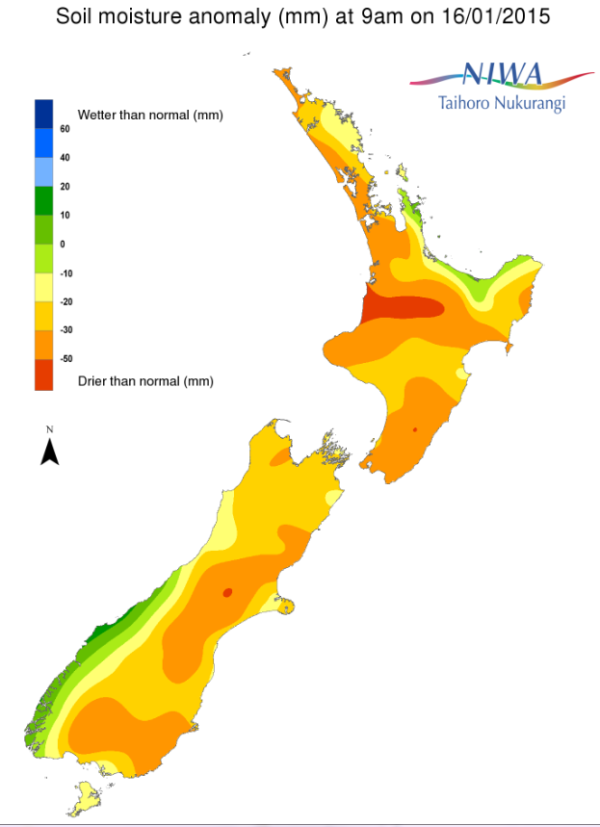
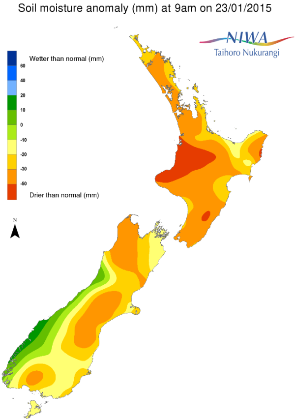
For the North Island, except for coastal areas of the Bay of Plenty and far northern Gisborne regions, nearly all of the island is experiencing much drier to severely drier than normal soils for this time of the year. Moreover, extremely drier than normal soils for this time of the year are present over much of the southeast part of the island from southern Gisborne to Hawke’s Bay and Wellington regions. Extremely drier than normal soils for this time of year also exist over much of the Waikato as well as parts of the Manawatu-Wanganui, Auckland and Northland regions.
For the South Island, severely to extremely drier than normal soil moisture levels for this time of year continue for the northern and interior sections of Otago as well as most of Canterbury, in particular central and southern Canterbury. Much drier than normal to severely drier than normal soils for this time of year are evident for much of the far northern part of the island from the eastern Tasman to Marlborough regions. Additionally, much drier than normal soils for this time of year exist over southern Southland, near and just northwest of Invercargill. Conversely, soils are wetter to much wetter than normal for this time of the year west of the Divide from Fiordland north to near Greymouth.
Week-to-Week Comparison
When compared to this time last week widespread dryness continues to cover the majority of New Zealand. For the North Island, it’s clear that soil moisture levels have continued to decrease over most, if not all, of the entire island. Furthermore, the coverage of severely drier to extremely drier than normal soils for this time of year has increased.
For the South Island, pockets of showers and thunderstorms were able to provide for some slight to modest soil moisture gains over central and southern Otago as well as parts of the Canterbury and eastern Marlborough regions. Soil moisture levels have decreased compared to this time last week from far northwest Canterbury through to southern Marlborough, to much of the Tasman and Nelson regions.
Commentary
For the North Island, when considering the current soil moisture anomalies for this time of year, hotspots include most of the eastern part of the island from near East Cape southwest to the Kapiti Coast, as well as much of the central and western Waikato, along with sizeable portions of the Auckland and Northland regions. Southern and far northern sections of the Manawatu-Wanganui region are also hotspots.
Computer models are predicting little, or no rain, through to early next week for nearly the whole of the island. As a result, it’s distinctly possible that some hotspot areas will continue to expand. Thereafter, in about 4-5 days, model guidance is suggesting the potential for some meaningful rain for parts of the east coast of the island, in particular from Gisborne to the South Wairarapa. If this were to occur, the hotspot size in this region may decrease.
For the South Island, hotspots exist throughout much of Canterbury and northern and interior sections of Otago. Continued dryness has brought about a new hotspot area from the far eastern Tasman region east and south to Marlborough. Farther south, parts of Southland have continued to dry over the past 1-2 weeks and will need to be monitored for possible hotspot development.
While there has been a decrease in hotspot coverage over the eastern part of the island, it’s questionable if the benefits from some rain earlier this week will persist as widespread dryness is forecast to continue through early next week for much of the island. Thereafter, model guidance indicates the potential of only patchy areas of rainfall beyond 4-5 days.
For hotspot regions, sustained rainfall over an extended period of time is needed to return conditions back to normal. Additionally, if current conditions persist or worsen, then drought conditions may be imminent.
Pictured below: Soil Moisture Anomaly Maps, relative to this time of year. On the left are values this time last week. On the right are the most recent values.


