A weekly update describing soil moisture across the country to help assess whether severely to extremely dry conditions are occurring or imminent. Regions experiencing these soil moisture deficits are deemed “hotspots”. Persistent hotspot regions have the potential to develop into drought.
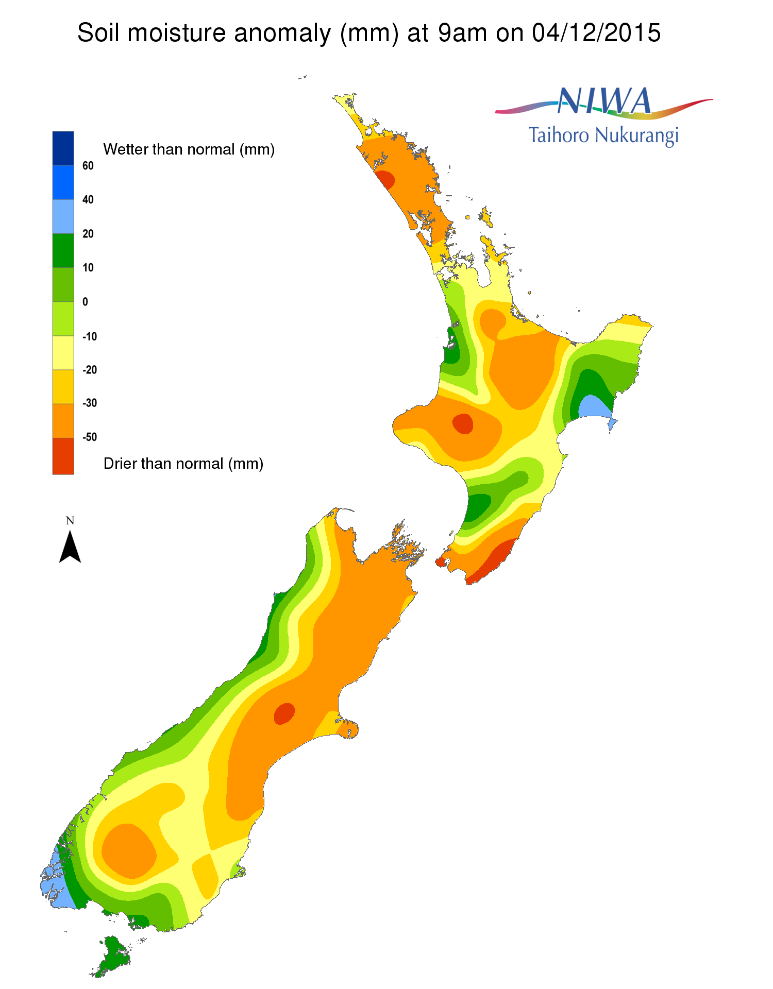
Soil moisture levels across the North Island have decreased for virtually the entirety of the island when compared to this time last week. Soil moisture from just east of Wellington north to the southern border of Hawke’s Bay is considered to be severely to extremely drier than normal for this time of year. Farther north, much drier to severely drier than normal soils for this time of year exist over central and eastern Waikato, parts of the Bay of Plenty and north coastal Gisborne. Much drier to severely drier than normal soils for this time of year dominate from near Auckland City through to nearly the whole of Northland. In spite of reduced soil moisture levels from northern Hawke’s Bay to central Gisborne, levels remain in the near normal range.
While there has been some fluctuation in soil moisture levels over the past week across the South Island, generally speaking, levels are similar to this time last week. The driest soils for this time of year continue from the far eastern Tasman region through nearly all of Marlborough, as well as the vast majority of eastern Canterbury through to extreme northern Otago. Soil moisture in these regions is generally much drier to severely drier than normal for this time of year, with pockets of extremely drier than normal soils for this time of year.
Outlook
For the North Island, showers are expected through Sunday morning. Rainfall will be greatest over the western half of the island. High pressure and generally dry weather will dominate most of the island Sunday evening through to Wednesday morning. There are indications scattered showers and thunderstorms may occur over the central part of the island, from Thames to the Tararuas, Wednesday afternoon and evening and then again Thursday afternoon. In total, by Friday afternoon, indications are that 10-20 mm of rain may occur for the week for most of the island with locally higher amounts about the Kapiti Coast and the Taranaki region as well as where any thunderstorms form in the aforementioned locations.
Consequently, soil moisture levels are likely to remain the same or decrease for much of the island. The exception may be for western portions of the central and lower part of the island where soil moisture may remain steady or increase.
For the South Island, widespread rain and thunderstorms are forecast to occur on Saturday from Southland north along and west of the Divide, with showers and thunderstorms expected Sunday. East of the Divide, rainfall will be generally much lighter and less widespread over the weekend. After a mostly dry Monday for much of the island, mostly diurnally driven scattered showers and thunderstorms are expected Tuesday through to Thursday. However, activity will likely be greatest about the foothills and around the Divide itself where lift will be greatest due to the orographic effects. By Friday afternoon, weekly rainfall is likely to be from 25-75 mm (locally higher amounts possible) along and west of the Divide, with 10-25 mm possible about Southland and coastal Otago. Farther north and east of the Divide, weekly rainfall is likely to be less than 15 mm, and in many locations, less than 10 mm.
Soil moisture levels are likely to remain steady or increase for parts of Southland as well as along and west of the Divide. However, for the remainder of the island soil moisture levels should remain the same or decrease.
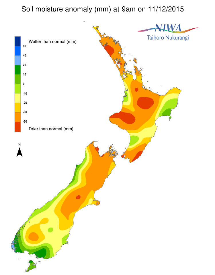
For the North Island, a hotspot exists from the Wairarapa to east of Wellington City. We are watching for potential hotspot development by this time next week over portions of the east and southeast Waikato as well as portions of the Auckland and Northland regions, chiefly north of Auckland City.
For the South Island, hotspots exist in eastern Canterbury and parts of northern Otago, as well as much of the area from Marlborough to eastern Tasman.
Background
Soil moisture deficit
Soil moisture deficit is the amount of water needed to bring the soil moisture content back to field capacity, which is the maximum amount of water the soil can hold.
Soil moisture anomaly
Soil moisture anomaly the difference between the historical normal soil moisture deficit (or surplus) for a given time of year and actual soil moisture deficits.
Definitions
“Extremely” and “severely” dry soils are based on a combination of the current soil moisture status and the difference from normal soil moisture (see soil moisture maps at https://www.niwa.co.nz/climate/nz-drought-monitor/droughtindicatormaps)
Download
Download Hotspot Watch for 11 December 2015 [118 KB PDF]
Soil moisture anomaly maps