This work was undertaken under the Future Coasts Aotearoa programme Research Aim 1

A risk screening tool that identifies areas of potential exposure to shallow groundwater.
Sea-level rise due to climate change is driving increases in groundwater levels in some coastal areas. Before addressing sea-level rise, it is useful to understand where shallow groundwater is already present.
High groundwater causes soggy ground, water ponding, surface flooding after heavy rain and, as a result, damage to assets such as roads, underground infrastructure and building foundations. High water tables and saltwater intrusion in groundwater are also driving the need for land use reassessments.
Where is shallow groundwater present?
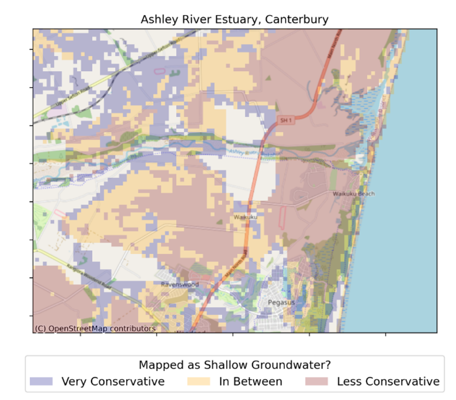
The Shallow groundwater screening tool shows areas that could be exposed to shallow groundwater, right now, based on existing groundwater measurements.
The dataset covers the entire extent of New Zealand where the elevation is less than 100 m above sea level and where the area was mapped as an aquifer by the New Zealand groundwater atlas: hydrogeological-unit map of New Zealand.
View Shallow groundwater screening tools:
Local Scale: The outputs can be used as a risk screening tool, to understand which areas could be exposed and require more detailed local investigation and assessment, and which areas are unlikely to be exposed.
The outputs also provide information on how certain we can be that shallow groundwater is present or not present, which can be used for hazard management and development planning. In most instances, we would expect users of the information to undertake more detailed assessments of the areas that are shown to be potentially exposed before making any significant decisions.
At this stage, the Shallow groundwater screening tool does not include any predictions of how much water tables could rise with rising sea levels and land subsidence. This is being addressed elsewhere within the Future Coasts Aotearoa research programme.
About the statistical model
We can find out whether shallow groundwater is present at a given location relatively easily, either by looking at data from existing local bores or by excavating a trial pit or hand augering where no previous information is available. But the depth to groundwater can vary significantly over relatively short distances and hence we cannot identify areas with potential shallow groundwater at scale without either extensive and costly investigations, or modelling.
We know from both theory and practical experience that depth to groundwater varies with land elevation, proximity to rivers, streams, and the coastline, soil properties, and other environmental variables. We therefore used a machine learning technique to determine which combinations of environmental variables provide the best predictions of depth to groundwater.
The machine learning model, which uses a method called Random Forest via a novel implementation developed for this study, was trained using all groundwater readings from 79,000 locations (where the well depth or screen is less than 30 m below ground level) with data available and national datasets of environmental variables like soil properties to provide the best possible prediction of whether shallow groundwater is likely or unlikely to be present on a 100 x 100 m grid for all land below 100 m elevation.
The model developed to create this product was trained using all accessible groundwater depth information held in Regional Council and Territorial Authority databases and in the New Zealand Geotechnical Database. This comprised readings from approximately 110,000 locations around the country.
Advantages of the statistical approach
The model results tell us the likelihood of finding shallow groundwater in every 100 x 100 m area below 100 m above sea level. This means that we can select a set of model results which suit a particular purpose. Like any model, the outputs have intrinsic uncertainties. The model will miss some shallow groundwater areas (false negatives, Type II error) and incorrectly identify some areas as shallow groundwater (false positives, Type I error). The strength of this tool is that we have provided a detailed analysis of the probability and type of errors so that users can make informed decisions about how to best use the data for their specific application.
The correct Type I and Type II error thresholds depend on the application and the consequences of missing potential shallow groundwater areas. We cannot provide a one-size-fits-all recommendation, but we can provide some general guidance:
Lower Type II Error Thresholds (e.g., 0.1):
- More conservative approach to missing shallow groundwater areas
- Higher number of false positives (areas incorrectly identified as shallow)
- Suitable for applications with low risk tolerance where missing shallow groundwater areas is particularly problematic
- Best for scenarios where the cost of missing a shallow groundwater area is high relative to the cost of false positives.
Higher Type II Error Thresholds (e.g., 0.3):
- More balanced predictions
- Fewer false positives at the cost of false negatives
- Better for applications requiring higher certainty that identified areas are truly shallow
More suitable when false positives are costly or resource-intensive to verify and the cost of missing a shallow groundwater area is lower.