Delft3D is an open source software package and modelling suite which allows users to model and look at water movement, sediment transport and channel morphology, and water quality for rivers, estuaries and coastlines.
More information about Delft3D
We are contributing to and testing the model so that it can be used to simulate the response of braided rivers and their ecosystems to the changes in river flow associated with water use schemes, such as dams.
The issue
Braided rivers are iconic features of the New Zealand landscape.
Their existence depends on abundant supplies of gravelly bed material and frequent disturbance by floods, and they are defined by networks of braids that are forever changing and shifting.
The frequent disturbances have led to unique communities of in-stream and terrestrial organisms (plant and animal) that have adapted to this changing physical environment. For example, the channel changes are sufficiently intense that riparian vegetation is naturally controlled, leaving bare gravel bars and islands which make relatively predator-safe habitats for river birds, including rare/endangered species such as the black stilt.
The concern is that water-use schemes that 'de-energise' braided rivers by reducing the size and/or duration of flood flows e.g. main-stem or tributary dams, or diversions into off-channel water storage reservoirs (collectively termed 'flood harvesting') might substantially change the river form, behaviour, ecosystems, and other environmental services. For example:
- with reduced flood size and frequency, riparian vegetation may establish semi-permanently on islands, degrading bird habitat and stabilising channels
- channels may be affected by algal blooms for extended periods
- the braided rivers' mouths, called hapua, may be closed by shingle deposited by waves, inhibiting fish migration and flooding river mouth settlements
- the supply rate of river gravel to beaches may be reduced, promoting coastal erosion.
The challenge is to identify how the magnitudes of these responses relate to the extent of flow change, so that limits and rules can be set on flood harvesting that will allow these environments and services to be sustained at acceptable levels.
The approach
Our approach is to explore the geomorphic* responses to flow change and discover the limits of tolerable change with the aid of 'numerical' braided rivers. We are doing this with our own modified version of the open source Delft3D model. Delft3D is based on a robust 2- or 3D hydraulic model, but it also incorporates sediment transport and evolves both the riverbed morphology and the sizing of the gravel mixtures that form the surface of the riverbed and the layers underneath. It also simulates gravity-driven processes such as bank erosion – which makes it what's termed a 'morphodynamic' model.
In addition, the model domain can be covered in vegetation, which increases flow drag which goes on to change flow patterns and velocities. Our work to date with Delft3D has focussed on three threads:
- improved simulation of bank erosion and dynamic braid-shifting
- optimising parameter choices to render depths and velocities more accurately
- using the model to simulate riverbed weed removal and the feedback between vegetation cover and flow velocity.
* Geomorphology is the study of landforms, their shape, and the processes that form them.
Progress
Thread one - improved simulation of bank erosion and dynamic braid-shifting
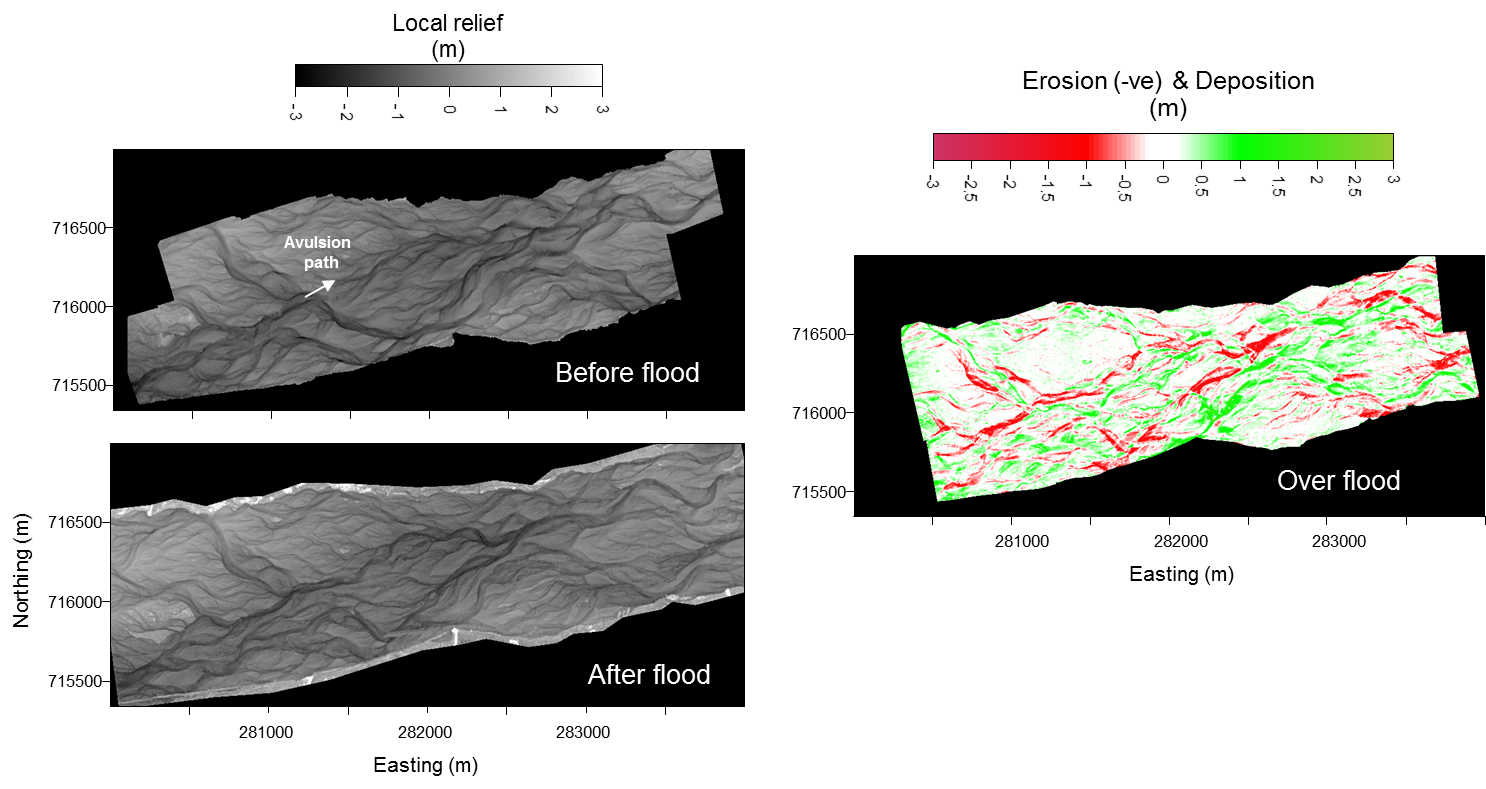
The first thread tested the model's predictions of channel shifts against surveyed changes in bed topography and channel patterns along a 4 x 1 km reach of the Waimakariri River, near Christchurch airport.
In 2000, our surveys captured an 'avulsion' event – the overall braid pattern of the river was substantially reset. During a 900 m3/s (likely to occur more than once a year) flood, the river opened up a new belt of active braiding along the northern side of its channel - previously, the active braid belt had swung along the southern side. The actual change is recorded in Figure 1. The Delft3D model reproduced this avulsion event and showed that it occurred as a minor braid on the north bank progressively enlarged and 'stole' more water from a main braid that swung towards the south bank.
A movie of this Delft3D simulation can be seen (and downloaded) below. The movie maps evolving water depth (blue to red shading indicates deepening water). Currently, we are working on improved algorithms to simulate the bank erosion process, because we have found that the modelled braids are less inclined to move sideways than observed in the field. One of our team members, NIWA river modeller Richard Measures, was awarded the 2012 Delft3D Code Contributor of the Year prize by Deltares (Delft3D source developer, the Netherlands).

Waimakariri Delft3d simulation from NIWA on Vimeo.
Thread two - optimising parameter choices to render depths and velocities more accurately
The second thread was aimed at optimising the choice of hydraulic parameters. These would produce the most accurate rendering of depth and velocity (key determinants of physical habitat) and bed shear stress (which drives sediment transport and channel evolution). We used datasets collected from the Rees River in Central Otago for the international ReesScan project, in which NIWA was a collaborator.
The ReesScan project used semi-automated ground-based laser-scanning technology (Figure 2) to rapidly survey between floods a 2.5 km long segment of the Rees River at exceptionally detailed resolution (Figure 3). The Delft3D model has been set up for several of these surveys and its hydraulic output compared against data collected with an acoustic-doppler current profiler (ADCP) mounted on a small tethered raft. An ADCP beams a sound pulse through the water column and picks up return echoes from fine particles and bubbles suspended in the water. The frequency of the echoes depends on the speed of the particles; since they move with the water, this provides a measure of the current speed.
This comparison revealed that the rate of momentum transfer in the river between fast and slow moving sections (the horizontal eddy viscosity) needed to be adjusted in the model to better represent real river systems. This also showed that little accuracy was lost by using the same value of drag coefficient everywhere over the riverbed (the drag coefficient represents the friction between the flow and the channel bed and banks). This analysis has been advanced mainly by Richard Williams, a PhD student from the University of Aberystwyth in Wales, during recent visits to NIWA.
Thread three - using the model to simulate riverbed weed removal and feedback between vegetation cover and flow velocity
The third thread involves applying the Delft3D model to a braided reach of the Ahuriri River, in the McKenzie Country, which is infested with lupins (a flowering plant from the legume family).
The project aims to reproduce the interactions between flows, the shape and structure of braids, and lupins that have been observed during a field survey. It is being undertaken by PhD student Luke Javernick from the University of Canterbury, with modelling assistance and co-supervision from NIWA. It is directly relevant to concerns that:
- lupins degrade bird habitat by providing cover to predators, and by altering the shape and structure of braid beds by focussing flows into main channels
- flood-damping in high country braided rivers might lead to more widespread infestations of lupins.
While still in progress, this study has already clarified the flow-drag created by lupins and the typical channel processes and velocity thresholds required to remove them (Figure 4) – precursors to numerically simulating lupins' effects on channel shape and structure and their removal during floods.
This year, we will integrate ecosystem processes into our Delft3D braided river models, so that we can begin numerical explorations of the consequences of flow regime change on physical habitat, algal flushing, and invertebrate population evolution. This will use the DELWAQ (water quality and ecology) module of the Delft3D modelling suite, and will bring us a step closer to our vision of having a numerical braided river for evaluating and managing the consequences of water use schemes.
External People Involved:
Richard Williams (University of Aberystwyth)
Luke Javernick (University of Canterbury)