Neutral ENSO conditions presently exist in the tropical Pacific, but El Niño is likely by the end of winter if the present warming rates continue.
However, patterns of enhanced convection and cloudiness in the tropical Pacific still show the remnants of La Niña, indicating the ocean-atmosphere feedbacks necessary for El Niño development are not yet in place.
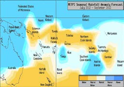
The ITCZ is south of its normal position to the east of the Dateline, with below normal rainfall north of the Equator and above normal rainfall just south of the Equator.
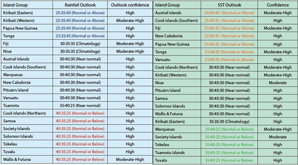
Near or above normal rainfall is forecast for Western and Eastern Kiribati, Tonga, and Papua New Guinea. Near normal rainfall is expected for the Austral Islands, the Southern Cook Islands, the Marquesas, New Caledonia, Vanuatu, Tuamotu and Pitcairn. Normal or below normal rainfall is forecast for the Northern Cook Islands, Samoa, the Society Islands, the Solomon Islands, Tokelau, Tuvalu and Wallis & Futuna. No clear guidance is offered for Fiji and Niue.
The global model ensemble continues to show the development of El Niño–like SST signals, with further east to west extension of warm anomalies in the equatorial region to the east of the Dateline in the coming three months. Normal or below normal SSTs are forecast for the Tuamotu Archipelago, the Society Islands, Tuvalu, Tokelau, and the Marquesas. Near normal or above normal sea surface temperatures are forecast for Papua New Guinea, New Caledonia, Vanuatu, Fiji, Tonga, the Austral Islands and the Southern Cook Islands. Near normal SSTs are forecast for Pitcairn Island, Wallis & Futuna, Western Kiribati, the Solomon Islands, the Northern Cook Islands, Niue and Samoa. No clear SST guidance is offered for Eastern Kiribati.
The confidence for the rainfall outlook is moderate to high. The average region–wide hit rate for rainfall forecasts issued in July is 65%, two percent higher than the long–term average for all months combined. The SST forecast confidence is moderate to high across the region, and uncertainty is greatest near Niue and the Society Islands.