Tropical Cyclone Update
Five tropical cyclones so far
Five tropical cyclones have occurred so far this season, which is well below average at this stage. 'Claudia' developed west of New Caledonia at 21°S 157°E on 11 February, and was the first this season to form west of the date line, reaching hurricane force (with estimated maximum sustained winds of about 140 km/h) as it tracked southeast to pass north of Norfolk Island from 12-13 February. A new tropical cyclone, 'Des' developed northwest of New Caledonia near 19°S 161°E on 6 March. So far, maximum sustained winds have reached about 95km/h. It is expected to take a southeast track toward northern New Zealand. This is still the period of peak tropical cyclone occurrence for the Southwest Pacific. On average two tropical cyclones occur in March in seasons similar to the present, decreasing to one during the April/May period. The highest frequencies have normally occurred over the Coral Sea east to Fiji, including Vanuatu and New Caledonia. The April issue of the ICU will provide an update on tropical cyclone information.
El Niño Update
The following is based on a statement prepared for the United Nations Interagency Task Force on Natural Disaster Reduction as a collaborative effort between the World Meteorological Organization and the International Research Institute for climate Prediction (IRI), drawing also on contributions from regional climate authorities including the Australian Bureau of Meteorology and NIWA, issued on 6 February 2002. NIWA has included additional information (highlighted) due to trends over recent weeks, and will continue to monitor the situation. Further updates will provide readers with information on possible impacts on the Southwest Pacific Island climate.
Climate Patterns in the Pacific
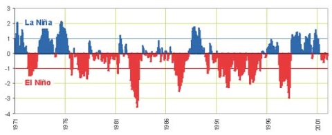
Interactions between the atmosphere and ocean in the tropical belt of the Pacific Ocean modulate global weather and climate patterns. During El Niño events, for example, sea temperatures at the surface in the central and eastern tropical Pacific Ocean become substantially warmer than normal. During La Niña events, the sea surface temperatures in these regions become lower than normal. These temperature changes can drive major climate fluctuations around the globe, and, once initiated, such events can last for 12 months or more. The last El Niño event occurred during 1997-1998 with severe drought affecting the western Pacific region, especially communities in Papua-New Guinea. This was followed by the prolonged La Niña phase that extended from mid-1998 to early 2001.
Present Situation and Outlook
Historical records show the approximate March-June period to be a favoured one for transitions to El Niño or La Niña. Most expert interpretations indicate that it is rather early in the year for a confident El Niño outlook to be made for the remainder of 2002. However, developments in the tropical Pacifc are leading the experts to watch the situation very closely and to remain on alert. The conditions beneath the surface of the Equatorial Pacific that have attracted attention were largely triggered by a significant burst of westerly winds in the Equatorial western Pacific during December. This burst created a pulse of warmer than normal water beneath the surface that is currently migrating east in the eastern Pacific and has just appeared at the surface near the equator along the South American coast. Present conditions in the tropical Pacific are thought to be unlikely by themselves to trigger an El Niño, and further initiating signals will be watched for in the next few weeks and months. The onset of further significant westerly wind bursts in the Equatorial western Pacific could enhance the development of an El Niño. The unusually warm conditions at present in the Equatorial Pacific near the dateline could also contribute to the onset of an El Niño.
Summary of the present situation
- Warm water has just appeared at the surface in the eastern Equatorial Pacific.
- Computer models vary on whether the situation will develop further into an El Niño event.
- The potential for the onset of El Niño events in the past has generally been clearer towards the end of the first quarter of the year.

