How does NIWA map the seafloor?
Multibeam echo sounders emit a fan of sound beams to the seafloor to scan a wide swath of the seabed in great detail. Compared with conventional echo sounders – which direct a single beam of sound to the seabed directly below a ship – multibeams show more detail and greatly reduce ship survey time and cost.
How it works
The hull-mounted multibeam transceiver sends out a beam of sound waves (see diagram below) which are reflected off the seafloor, back to a receiver on the ship.
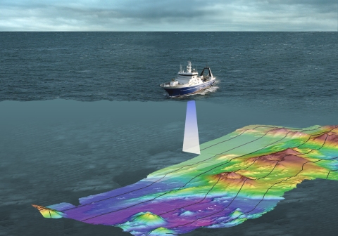
In Tangaroa's Kongsberg EM302 multibeam system, the signal is divided into 288 separate beams, which form a swath on the seafloor. The swath width increases with water depth to a maximum of seven kilometres at a depth of about 2500 metres. It can map the seafloor at depths of up to 8000 metres.
We also use a portable high-resolution shallow water multibeam system (Kongsberg EM3002D). This uses the same technique but with 508 beams, very high resolution, and a range of about 1–200 m.
Building a 3-D picture of the seafloor
The multibeam system calculates water depth from the time it takes the sound to travel to the seafloor and back to the ship.
Seafloor substrate hardness and texture are indicated by the strength of the return echoes ('backscatter'). For instance, weak echoes often indicate soft mud; strong echoes indicate rocks.
Sophisticated software combines these data with precise location data from satellite-based Differential Global Positioning Systems (DGPS) to produce various pictures of the seafloor, including:
Charts of water depth ('bathymetry') as contours or colour-coded charts.Digital elevation models – a colour-shaded relief model of the seafloor, like an aerial photograph.Geo-referenced maps of seafloor habitats and substrates.
Preliminary charts can be plotted onboard within hours, allowing scientists to direct further survey work to areas of particular interest. These images give unprecedented insight into the intricate shape of the seafloor and the processes that shape it.
Ocean Survey 20/20
Ocean Survey 20/20 is a 15-year Government project, established in 2004, to survey and explore New Zealand's oceans, including those around Antarctica, to better manage and sustainably develop our ocean territory.
The vision of Ocean Survey 20/20 is to provide New Zealand with the knowledge of its ocean territory to:
Demonstrate our stewardship and exercise our sovereign rightsConserve, protect, manage and sustainably utilise our ocean resources, andFacilitate safe navigation and enjoyment of the oceans around New Zealand.
The geographic area covered by the programme is primarily New Zealand's EEZ, continental shelf and the Ross Sea region.
Multiple agencies are contributing to the project, which is being overseen by Land Information New Zealand. Key topics of research include:
Sovereignty, stewardship, security and management.Maritime safety.Natural hazards and risk management.Fishing and aquaculture.Biodiversity and ecosystems.Minerals, hydrocarbons and other physical resources.Climate.
For more information visit: http://www.linz.govt.nz/hydro/projects-programmes/ocean-survey-2020/about-ocean-survey-2020