NIWA recently used the Catchment Land Use for Environmental Sustainability model system (CLUES) to evaluate the potential catchment-scale efficacy of two mitigation strategies at reducing annual loads of sediment and nutrients to the Kaipara Harbour.
Land-use change over the past century (native forest to forestry and agriculture) has resulted in the loss of marine habitats and the degradation of coastal ecosystems in the harbour.
The strategies simulated are conservation planting of native forest on steep pastoral land and stock exclusion by fencing along all streams and first order streams accessible to stock. The application demonstrates how models such as CLUES can be used to support catchment planning and management.
It was found that the Wairoa River catchment has the highest estimated loads for nutrients and sediments, largely due to its size in relation to the rest of the drainage area. However, other catchments have higher yields. Both mitigation strategies reduced estimated TN loads to the harbour by around 17 per cent. Stock exclusion of all streams results in predicted reductions in TP and sediment of 27 and 38 respectively whereas conservation planting resulted in predicted reductions of 37 and 36 respectively.
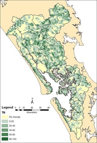
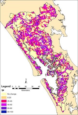
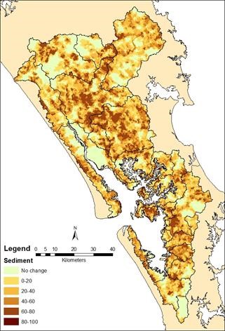
Percentage reduction from the default land use scenario in CLUES generated yields simulated for conservation planting on LUC 6-8 land (Scenario 1ii). Left, TN; Middle, TP; and Right, sediment. Changes are mapped with 20 percentile blocks.
NIWA Contacts:
Annette Semadeni-Davies and Kelly May.