Written by Seth Carrier, NIWA Meteorologist/Forecaster
On this page:
- Clouds
- Pressure
- Fronts
- Did you know that you can get a job studying and predicting the weather?
- Experiment – make a cloud in a bottle!
- Quiz – intro to weather and meteorology
Download a shorter version of this lesson in PowerPoint or as a PDF or continue below to see the lesson in full.
You probably hear the word weather almost every day, but what is it really? You can think of the weather as what you see out your window every day. Is today sunny, cloudy, windy, rainy or stormy? All of those things are part of the weather.
Weather is what we see and feel in the short-term, meaning over the next few days or the next couple of weeks. When we look at trends in the atmosphere over longer time frames, such as months or years, that is called climate. We will look at climate more closely in a later lesson.
Clouds
One of the most noticeable aspects of weather are clouds. You see clouds almost every day, but maybe you’re wondering how they form and why they’re able to “float” in the sky.
It might be hard to believe, but clouds are made up of billions of tiny water droplets. All air holds water, but near the ground it’s usually in the form of an invisible gas called water vapour. If this air near the ground is warmer than the surrounding air, it begins to rise. The rising air cools as it gets higher in the sky, and cool air can’t hold as much water vapour as warm air. At this point the water vapour condenses (changes from a gas to a liquid) around very small pieces of dust floating in the air and a tiny water droplet is formed. When billions of these droplets come together you have a cloud! Why do clouds float in the sky? Because clouds start as warm air, they have a higher temperature than the air around them. As long as a cloud is warmer than the air around it, it will float in the sky. Why are clouds white? Sunlight is made up of all the colours of the rainbow and together these appear white. When sunlight hits a cloud, the water droplets inside the cloud are big enough to scatter the light of all seven colours almost equally, making the cloud look white too. But why do rain clouds usually look grey? In rain clouds, the water droplets are larger and scatter light more, meaning less light makes it out of the bottom of the cloud and it looks darker. How do clouds move? Clouds are pushed along by the wind at their level of the atmosphere. Usually low clouds move slower than high clouds. In fact, high-level cirrus clouds (see below) can move over 160 kilometres per hour! That’s much faster than a car travelling on a motorway!
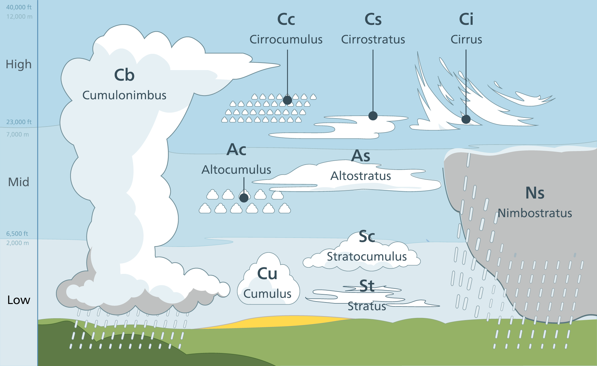
Common types of clouds
Cirrus clouds: These are the highest clouds, usually forming above 6,000 metres. In fact, these clouds are so high and so cold that they’re made of ice crystals instead of water droplets! They look thin and wispy as strong winds high in the sky blow them into long streams. Cirrus clouds can indicate that the weather is going to change for the worse over the next 24-36 hours. Cumulus clouds: These clouds are fluffy and white and look like cotton balls floating in the sky. Cumulus clouds often form only around 1,000 metres above the ground. Cumulonimbus clouds: Tall, ominous-looking clouds that can become thunderstorms. Expect heavy rain, lightning, hail, and maybe even tornadoes when you see these clouds. Stratus clouds: Flat, grey clouds that cover the whole sky. These clouds usually produce drizzle or light rain. Fog: Fog is just a regular cloud that forms at ground level. Fog typically forms when warm air blows over much colder soil or even snow.
Pressure
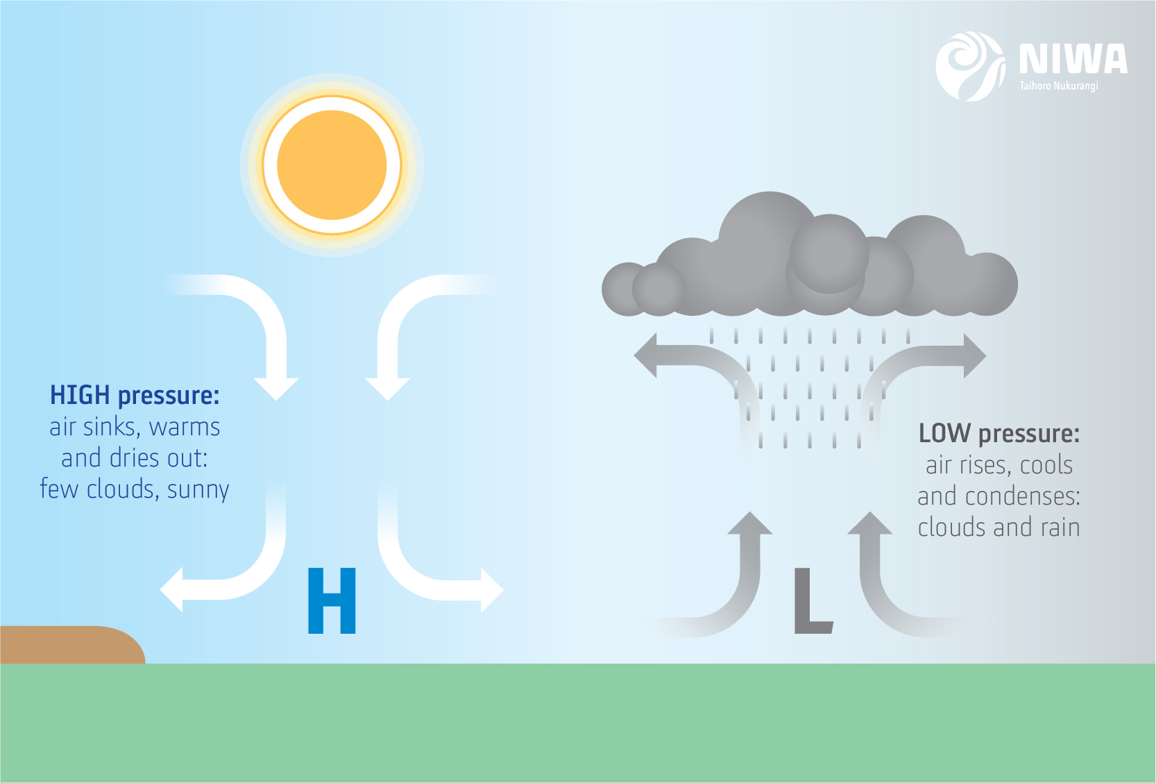
One of the main things we have to watch to understand the weather is the presence of low and high pressure.
Areas with low pressure are usually associated with bad weather. If an area has low air pressure, air from neighbouring areas with higher air pressure, will move in and force the air to move upward, as it has nowhere else to go. When the air moves up, the water vapour will condense and lead to the formation of clouds and rain.
Areas with high pressure, are typically associated with good (happy!) weather. In high-pressure areas, the air sinks toward the ground, leading to dry, pleasant weather and usually lots of sunshine!
Fronts
Along with high and low pressure we also find fronts. A front is a boundary between two different air masses (usually one warm and one cold), and along fronts there is often stormy weather, sharp temperature changes, and rapid shifts in wind direction.
A cold front divides warm air and cool air, moving so that the cooler air replaces the warmer air. A warm front works in the opposite way, with warmer air replacing the cooler air.
Did you know you can get a job studying and predicting the weather?
It’s true! People who study the weather are known as meteorologists, and you’ve probably seen them talking about the weather on television before. Other meteorologists work at airlines, power companies, or might even tell the Black Caps if their match may be delayed by rain.
Most meteorologists go to university for at least four years to learn how to predict the weather, and some even longer! Even after graduating from university, it takes lots of practice to get good at predicting the weather, and meteorologists are always learning.
What is a meteorologist?
Experiment – make a cloud in a bottle!
You see clouds in the sky almost every day. Now it’s time to make your own!
What you'll need:
- A clear 2-litre plastic bottle
- Warm water
- Matches (ask an adult for help using the matches)
Instructions:
- Fill the bottle two-thirds full of warm water and screw the cap on. As warm water evaporates, it adds water vapor to the air inside the bottle. This is the first ingredient to make a cloud. Giving the bottle a shake will allow the air at the top of the bottle to become saturated with water vapour.
- Squeeze and release the bottle and observe what happens. You’ll notice that nothing happens. Why? The squeeze increases the pressure inside the bottle and increases the temperature. The release represents a drop in pressure and temperature. If the inside of the bottle becomes covered with condensation or water droplets, just shake the bottle again to get rid of them.
- Take the cap off the bottle. Carefully light a match and hold the match near the opening of the bottle.
- Then drop the match in the bottle and quickly put on the cap, trapping the smoke inside. Dust, smoke or other particles in the air is the second ingredient to make a cloud.
- Once again, slowly squeeze the bottle hard and release. What happens? A cloud appears when you release and disappears when you squeeze. The third ingredient in clouds is a drop in air pressure.
Explanation:
Squeezing and releasing the bottle causes the air pressure to drop. The water vapour (water in its invisible gaseous state) in the bottle then condenses to form tiny water vapour droplets, but only when particles such as smoke are present. This is the same process happening when you see clouds in the sky!
Video tutorial:
Quiz – intro to weather and meteorology
Check out our weather and meteorology quiz over on Kahoot.
(The quiz works best on kahoot, but if you prefer a text version, you can download it as a PDF here).