Short-term to long-term data estimation
Many landowners and land developers have installed small portable climate data loggers and meteorological instruments on their properties. These instruments can be used to measure rainfall, wind speed, air temperature, etc. at very high temporal resolution (e.g. every 30 seconds). The data are very useful for learning more about the climate of a specific location, however one of the drawbacks is the record length of the measurements is often quite short (e.g. a few months to a year).
NIWA have developed a method whereby short-term data from a logger site are compared with data from nearby permanent climate stations. Statistical relationships are built up between the data sites that can be used to estimate the long-term climate at the logger location. These long-term climate estimates can then be used to assess the average climate and the year-to-year variability at the short-term data location, providing a much more valuable assessment of the climate of the site.
Virtual climate stations
How often have you found that there are no climate stations in the area you are interested in? Unfortunately, due to the constraints of land access and funding, this is a common problem that can not be resolved by simply doubling or trebling the current station network.
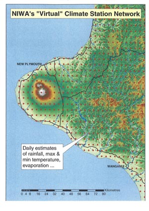
However, using sophisticated data interpolation techniques (developed and used for the production of climate maps), we are able to estimate daily values of rainfall, maximim and minimum temperature, evaporation etc. at every point on a ~5km grid over all of New Zealand (see the Taranaki example). As a result, synthetic long-term daily climate records can be generated for any location in the country. We call these data Virtual Climate Station data.
More information about our Virtual Climate Station data
NIWA climate maps
Contact
For further information regarding purchasing climate maps, GIS layers, or other climate data products please contact:
Dr Andrew Tait National Climate Centre NIWA Private Bag 14901 Wellington
Acknowledgements
NIWA’s climate mapping research has been funded by the Foundation for Research Science and Technology under the Public Good Science Fund contract C01X0202, “Adaptation to Climate Variability and Change”.
Climate mapping projects for the specific areas shown here have been additionally funded by Otago Regional Council, Tararua District Council, Far North District Council, Kaipara District Council, private businesses, and individuals.