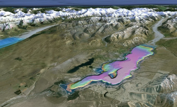
A pilot project has provided the most advanced mapping of a New Zealand lake ever and highlights the hazard to lakeside towns of tsunamis caused by landslides.
NIWA marine geologist Dr Joshu Mountjoy led a project to map the floor of Lake Tekapo using multibeam sonar equipment to collect high quality bathymetric maps. Seismic reflection survey equipment was then used to obtain images of the sediment under the lake floor.
Dr Mountjoy said the data revealed an unexpectedly dynamic lake bed with a huge range of processes shaping it.
"Lake Tekapo was created by large glaciers that flowed down the valley until 15,000 years ago, piling up sediment where Tekapo is today and carving into the valley sides. Since the glacier retreated the lake has been dammed and is used to generate electricity. Such hydropower schemes contribute around half our electricity.
"Today there are large rivers moving sediment into the lake and creating huge deposits known as deltas. Both these deltas, and the steep sides of both the lake bed and the mountains next to it, are prone to collapsing."
Dr Mountjoy said they had modelled tsunami from slope failures within and into the lake, based on the evidence for the size and location of past landslides. The results show that waves could exceed 5m at many locations around the lake shoreline.
The study has just been published by the Geological Society of London and presented as an opening keynote at an international conference on underwater landslides where other researchers presented historical example of large tsunamis in lakes.
"A really interesting aspect of the results from this study is that there is clear evidence that many landslides have occurred at the same time and we believe this has happened during large earthquakes. We cannot be sure if this is an Alpine Fault earthquake or something local, but it does mean there may be a natural warning if such an event happens again."
The results of the study were recently presented to the Tekapo community, to raise awareness of the hazard. Tsunami waves have the potential to damage infrastructure and cause flooding in areas with high numbers of tourists.
"This is not a unique hazard to Lake Tekapo, other large and popular lakes in the South and North Islands may experience tsunamis at some point," Dr Mountjoy said.
"Most people think of tsunamis as ocean-based, but they are just as capable of happening in lakes, although little work has been done on this worldwide. Given New Zealand's geological make-up, this is something New Zealand communities should be more aware of."
A key message from this work is that, as with the coastal environment, if people feel a long or strong earthquake they should move to higher ground and encourage others to do the same.
Researchers are hopeful the Lake Tekapo pilot study can be used as a basis for research on tsunami hazard in other large New Zealand lakes such as Wakatipu, Wanaka and Taupo.
The study was funded by the Natural Hazards Research Platform, and is a joint NIWA-GNS Science project with input from Otago University and Environment Canterbury.


