This project investigated the capabilities and utility of NIWA’s Cumulative Hydrological Effects Simulator (CHES) tool for facilitating discussions and decision making associated with setting and applying water quantity limits in the Grey River catchment on the South Island’s West Coast.
The issue
The National Policy Statement for Freshwater Management (NPS-FM) requires regional councils to set water quantity and quality limits for fresh water bodies that reflect local and national values.
To facilitate water quantity limit setting discussions and decision making, tools are needed to assist councils and stakeholders to characterise the current status and consequences of water use in a catchment, explore different water use and limit scenarios, and improve the robustness and transparency of water allocation planning.
In this project the Grey River catchment is used as a case study to demonstrate some of the features and capabilities of NIWA’s CHES software. This software predicts how water flows in the catchment will change under a combination of water uses and what these flow changes mean in terms of reliability of water supply and effects on instream physical habitat for two fish species.
The solution
CHES was set-up and calibrated for the Grey River catchment. This involved defining the catchment boundary and river network using the River Environment Classification (REC) system, calibrating a modified version of the underlying TopNet hydrological model (known as TopNet-GW2SW) to better simulate connections between surface water and ground water flows, and generating a database of existing consented water takes. The first or reference scenario (based on existing takes) was then run prior to setting up five alternative water allocation scenarios determined in consultation with West Coast Regional Council (WCRC). These alternative scenarios addressed the effects on reliability of water supply and habitat availability for two example fish species, adult brown trout and longfin eel of: (Scenario 2) allocation provisions under Policies 7.3.1 and 7.3.2 of WCRC’s Regional Land and Water Plan (RLWP), (Scenario 3) default limits under the proposed National Environmental Standard (NES, MfE 2008), (Scenario 4) adding a water storage reservoir to improve reliability of water supply, (5) adding a large new abstraction for a hypothetical farm development, and (Scenario 6) the potential effects of climate change.
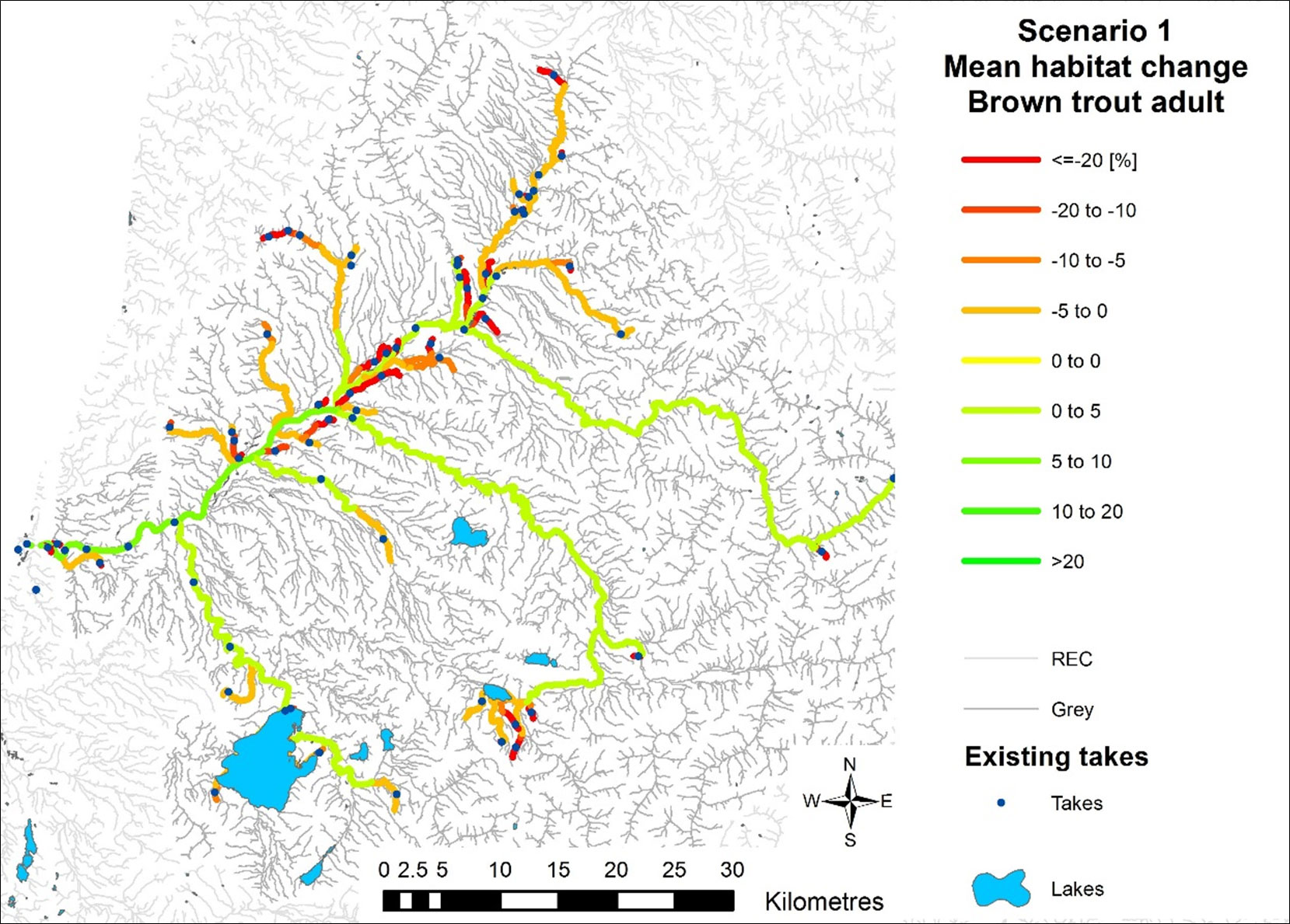
In the absence of reliable water abstraction volume data, in Scenarios 1 to 3 we assumed that whenever an abstractor is allowed to take water (based on the rules set in the scenario), the maximum allowable volume is taken, whether or not the water is needed (i.e., the results presented might be considered a ‘worst case’ scenario).
The results
Scenario 1 simulating the effects of currently consented abstractions demonstrated that 45 of the current 78 takes have a high reliability (>97.5%) of supply. However, 23 water takes had a reliability of less than 50%. Current consent conditions mean that on average across the catchment there is a 3.6% reduction in physical habitat availability for adult brown trout compared to natural flows that occurs 38% of the time.
Applying the allocation rules stipulated under WCRC’s RLWP (scenario 2) showed that most river reaches comply with these policies and there would be an average improvement in habitat availability of 1.1% for adult brown trout and 1.6% for longfin eels. However, there would be an average reduction of around 4% in reliability of supply.
Applying the rules outlined in the proposed NES under Scenario 3, the mean reliability of supply was 92% and habitat availability, on average would be 3.3% more for adult brown trout and 1.6% more for longfin eels compared to current water abstraction.
The climate change scenario simulated (the average of the 12 global climate model scenarios under A1B from the IPCC’s (2001) third assessment round) showed that, in general, the south-eastern part of the Grey River catchment will experience a reduction in Mean Annual Low Flow (MALF) while the north-western part of the Grey River catchment will experience an increase. However, these changes in flows result in no change in reliability for a typical abstractor, and some abstractors will have more reliable supply (the best case being a 157% increase). On average across all river reaches, only a 0.2 and 0.3% reduction in habitat availability (compared to current conditions) was predicted for adult brown trout and longfin eels, respectively.
Conclusions
The results of the various simulations demonstrate how CHES can be used to predict the outcomes of applying different water quantity limits in terms of both reliability of supply for existing abstractors and instream habitat change for fish. The next step is for WCRC (and other councils) with its community to weigh up the various consequences and decide which best meet their objectives.
Future refinements of CHES are expected to include quantification of uncertainty for the simulated reliability of supply and degree of habitat change.
Further information
Full report by Hoyle J, Diettrich J and Franklin P. 2016. Applying the Cumulative Hydrological Effects Simulator (CHES) for managing water allocation: A demonstration of CHES in the Grey catchment, West Coast. Prepared for West Coast Regional Council.
This project was also presented at the Water Infrastructure and the Environment conference in December 2016: CHES for the Grey River catchment.[PDF 180KB]