Quick and easy lake reporting
LakeSPI delivers information that is directly applicable to lake-ecosystem conservation and management. It is being widely used in regional environmental monitoring programs and for national and regional reporting.
Reporting on LakeSPI condition
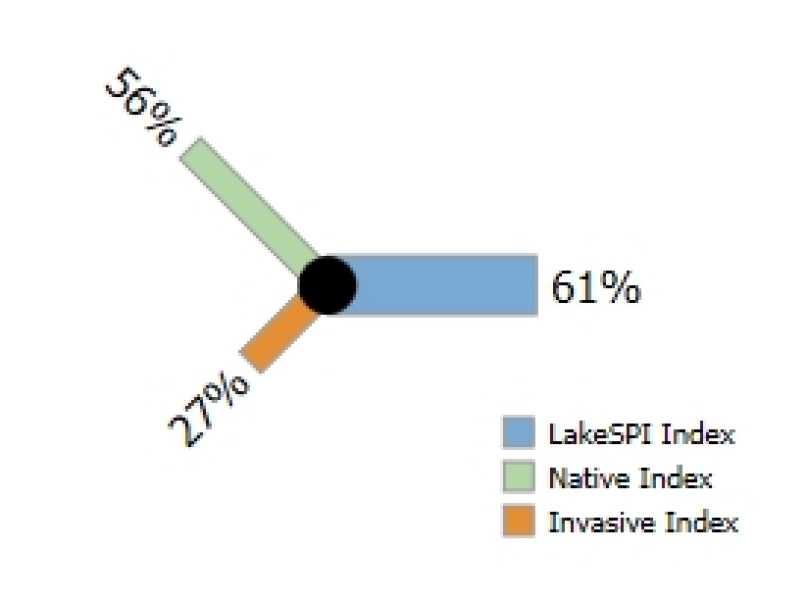
The LakeSPI method uses key features of aquatic vegetation structure and composition to generate three LakeSPI indices:
- Native Condition Index - Characterises the biodiversity and extent of native vegetation within a lake.
- Invasive Impact Index - Characterises the degree of impact from invasive weed species.
- LakeSPI Index - Provides an overall indicator of lake ecological condition.
A high Native Condition Index is favourable, while a high Invasive Impact Index is undesirable. The higher the LakeSPI index, the better the overall condition of the lake. LakeSPI indices are expressed as a percentage of a lake's maximum scoring potential which allows for a better comparison to be made between different types of lakes.
I want to report on the condition of a single lake
Reporting on lake status
LakeSPI indices provide a description of a lakes condition at the time of a survey. LakeSPI scores from multiple lakes can then be ranked to enable comparison with the status of other lakes.
For ease of reporting, five lake categories have been developed to support an MfE initiative for consistency in terminology and reporting:
- Excellent
- High
- Moderate
- Poor
- Non-vegetated
Lakes are classified according to the value of their most recent LakeSPI Index.
I want to report on the national status of a lake or group of lakes
LakeSPI status can be reported using a range of display formats available on the reporting site.
Table view – The table view shows the status of a lake or group of selected lakes (e.g., by Region) along with other lake details.
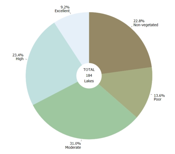
Chart view – A pie chart shows the relative proportion of lake categories for a selected group of lakes, a region's lakes, or a national overview.
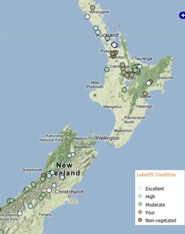
Map view – Lake categories can be viewed on a New Zealand map.
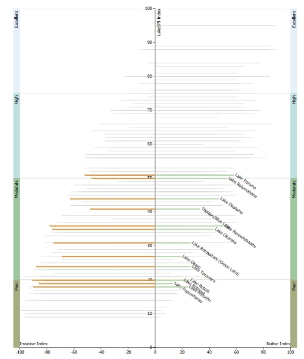
National status –The graph shows where each selected lake sits in comparison to all other New Zealand lakes, where LakeSPI results are available.
Reporting on lake trends
LakeSPI indices provide lake managers with information on present lake condition and a benchmark for monitoring future changes. They can also help assess the effectiveness of catchment and lake management initiatives by comparing lake indices over time.
To help put the LakeSPI indices into context, each lake is assessed using three reference states:
- Pristine (or Best Potential) condition - The best possible condition for a lake, as it would theoretically have been in pre-European times.
- Historical condition – Earlier assessments of lakes using the LakeSPI method according to survey date.
- Present day condition – Based on the most recent survey data.
I want to view changes in lake condition over time
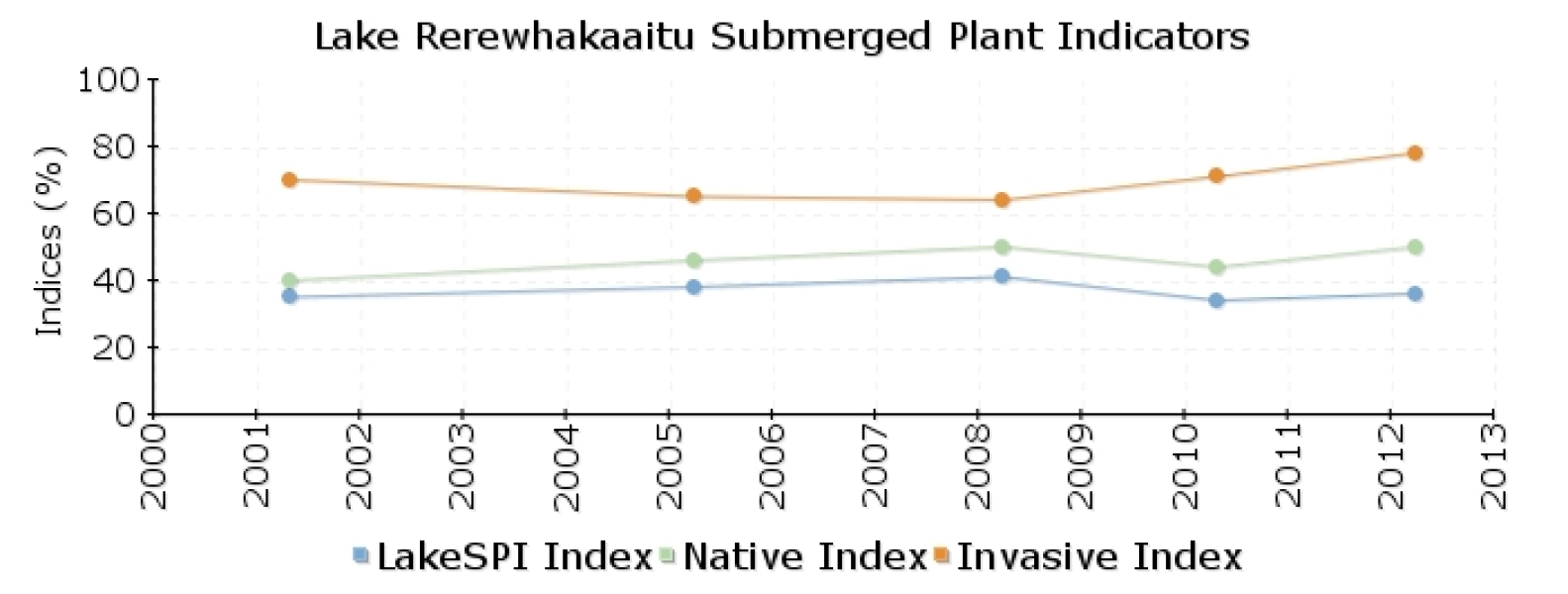
LakeSPI indices from multiple LakeSPI surveys can be used to indicate the direction of change over time. They can be viewed in two ways:
Time line – Changes in lake condition over time can be viewed on a graph.
Table view – Changes in lake condition over time can also be viewed in a table format.
I want to know if a lake is stable, improving or deteriorating?
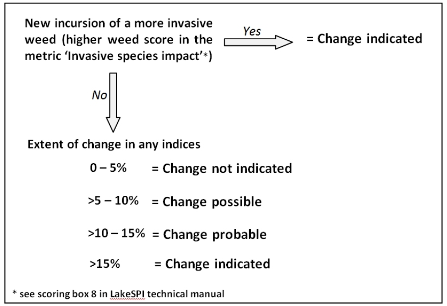
While LakeSPI users may wish to set their own threshold for recognised change in LakeSPI status, general guidelines have been developed by NIWA to give a scale of probabilities for change in lake condition based on expert opinion and a review of LakeSPI results to date.
Reporting on LakeSPI aquatic plants
I want to know what native plants are in a lake
The LakeSPI method assesses native diversity based on six key native plant community types:
- Turf community (PDF 2.3 MB)
- Isoetes (PDF 2.5 MB)
- Native pondweeds (PDF 2.2 MB)
- Native milfoils (PDF 2.2 MB)
- Charophyte species (PDF 2.3 MB)
- Charophyte meadows (>75% cover) (PDF 2.3 MB)
The presence of native plant types in a lake is recorded on individual lake report cards. If you want to learn more about a plant type, each plant name contains a link to provide you with more information.
Note: Because the LakeSPI method only identifies native plants at a genus or community level, this method is not suitable for providing a full inventory of aquatic plant species in a lake.
I want to know about the 'condition' of native plants in a lake
Native plant species and high native diversity are recognised in the LakeSPI method as representing healthier lakes that are in better ecological condition.
The Native Condition Index has been designed to capture the diversity and extent of indigenous plant communities present. Therefore, a high Native Condition Index score indicates better lake condition.
The Native Condition Index score can be reported using information found on the LakeSPI reporting site.
I want to know about the invasive plants in a lake
The LakeSPI method identifies ten key invasive plant species and assesses them based on an assessment of their known habitat tolerance range and severity of impact from worst to most benign as:
- Ceratophyllum demersum (PDF 2.9 MB)
- Hydrilla verticillata (PDF 2 MB)
- Egeria densa (PDF 2.9 MB)
- Lagarosiphon major (PDF 2.4 MB)
- Vallisneria australis (PDF 4 MB)
- Elodea canadensis (PDF 2.4 MB)
- Utricularia gibba (PDF 2.3 MB)
- Potamogeton crispus (PDF 2.4 MB)
- Ranunculus trichophyllus (PDF 2 MB)
- Juncus bulbosus (PDF 1 KB)
The presence of invasive species recorded in a lake can be found on report cards. If you want to learn more about each of the species listed above, click on the the plant name.
Note: The LakeSPI method is not suitable for providing a full inventory of aquatic plant species in a lake and is not designed to pick up early stages of establishment for any new invasive species. A site-targeted surveillance method would be required for this purpose.
I want to know what impact invasive species are having in a lake
The presence of invasive plant species is recognised in the LakeSPI method as being undesirable, due to their potential to displace native plant communities and adversely affect lake ecological condition.
The Invasive Impact Index has been designed to capture the degree of impact by invasive weed species. A higher score means more impact from exotic species, which is often undesirable.
The Invasive Impact Index score can be reported on using information found on the LakeSPI reporting site. Important note: A high Invasive Impact Index has the effect of reducing the overall condition used to characterise a lake.
I want to know the maximum depth of plant growth in a lake
The maximum depth of plant growth is recognised in the LakeSPI method as being a direct indicator of water clarity in lakes (except in shallow, fully vegetated lakes) and is recorded as the maximum depth at which a plant cover >10% ends.
Submerged plant depths can be found on report cards and are recorded for both native and invasive plant types.
Note: No plant depths will be recorded for vegetation that does not exceed 10% cover.

