Why do we need a hydrological model?
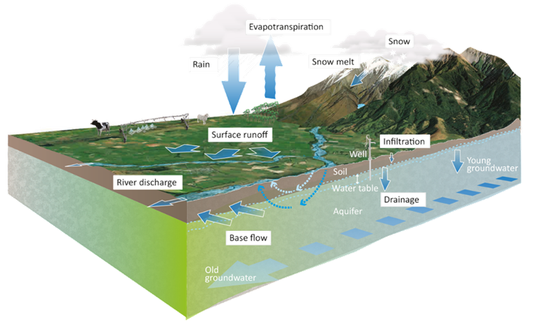
Models are needed because it is impossible to directly observe environmental variables at all locations, all the time or in the future. Hydrological models can make reliable predictions in ungauged catchments and about future conditions. If they are to be used to improve water management in New Zealand, hydrological models need to be flexible enough to represent a wide range of environmental conditions, but complex enough to represent the integration of natural and anthropogenic processes (such as those shown in the diagram below). To address this need, NIWA is leading the development of the New Zealand Water Model (NZWaM) in partnership with GNS Science, Manaaki Whenua – Landcare Research, Environment Southland, Horizons Regional Council and Gisborne District Council.
How does it work?
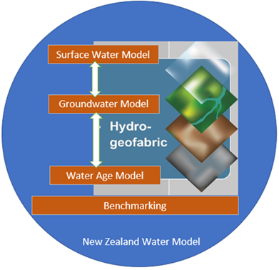
NZWaM uses a modular approach that links a wide range of environmental data with sub-models representing different hydrological processes. These sub-models can be added as they are developed. The physical domain of processes represented within NZWaM extends from the top of the atmosphere, to rivers, lakes, aquifers and estuaries.
NZWaM-Hydro is the first component of the NZWaM platform to be completed. It provides essential hydrological information for water management and planning at a national, regional, catchment and sub-catchment scale. NZWaM-Hydro is already being used for national and regional policy development, water allocation and flow setting, water accounting, and flow forecasting (both flood and drought). NZWaM-Hydro will be coupled to submodels for water quality (NZWaM-Water Quality) and ecology (NZWaM-Ecology) as they are developed.
NZWaM-Hydro’s surface water model is based on NIWA’s TopNet rainfall-runoff model and is used for environmental flow setting and for evaluating water resource availability. The surface water model represents evaporation, soil-moisture and groundwater recharge processes using soil, landcover and climate data held in a spatial database . The surface water model has been tested in a range of environments and catchment types to assess its applicability and performance across New Zealand.
The groundwater models used in NZWaM-Hydro are based on the GNS Equilibrium Water Table (EWT) model, the NIWA TopNet-Groundwater model and MODFLOW models
A water-age model is being developed with surface and groundwater isotope data from ongoing survey work by regional councils. The isotope data are used to identify the origin of stream water (i.e. direct rainfall, shallow sub-surface water or deep groundwater). This information is then to identify flow pathways between precipitation, river networks and aquifers.
NZWaM uses the coupled surface water, groundwater and water age models to represent water exchange between land, atmosphere, cryosphere, surface-water bodies and aquifers, and to specify locations and rates of water exchange.
NZWaM l benchmarking uses state-of-the-art methods to test each of the coupled models against observed data. Guidance on the use and limitations associated with the models is currently being produced. A cloud-based graphical interface, HydroDeskNZ, is being developed to enable users to securely access all components of NZWaM. HydroDeskNZ-users will be able set-up, parametrise run NZWaM, and generate time series of hydrological fluxes at specific locations.
Outputs to date
- High resolution digital river network providing permanent and ephemeral surface water flow pathways across New Zealand.
- The Hydro-geofabric – an updatable geospatial database that is coupled to the surface and groundwater modelling components of NZWaM. The database includes a combination of measured and simulated data (e.g., digital river network, soil and geological information, water isotopic chemistry, climate data), and derived parameter data (e.g., soil saturation, hydraulic conductivity).
- Time series of hourly river flows for every reach in the digital river network from the TopNet rainfall-runoff model, extending back to 1972. The time series are provided as both natural flows (based on hydrological processes) and actual flows (hydrological processes plus anthropogenic abstraction and redistribution).
- Time series of catchment-scale hydrological fluxes (e.g., evapotranspiration, groundwater recharge and discharge, snow accumulation and snow melt) and catchment-scale state variables (e.g., soil moisture, canopy storage, snow storage) for every catchment in the digital river network.
- Time series of spatially distributed, weekly-averaged groundwater levels across New Zealand from the National Water Table model, extending back to 2010. The groundwater levels have a spatial grid resolution of 250 metres.
- Static and dynamic maps of gaining and losing streams across New Zealand. The static maps categorise every reach in the digital river network. Dynamic maps are based on the National Water Table model and have a spatial resolution of 250 metres.
- Observed and predicted seasonally-averaged stable isotope chemistry for at every reach in the digital river network.
- A benchmark dataset of observed precipitation (point and gridded) and stream flow (continuous and spot gauging) time series, extending back to 1960. This harmonised dataset is the most extensive in New Zealand, and is used for hydrological model development, calibration and validation.
- HydroDeskNZ.The current version of HydroDeskNZ runs the surface water module of NZWaM. The next version will run the coupled surface water groundwater module.
NZWaM applications
- Integrated (surface and groundwater) resources planning
- Dynamic water allocation
- Infrastructure planning and feasibility studies
- Climate change scenario testing and adaptation
- Environmental flow setting
- Irrigation and hydroelectric planning and consenting
- Water accounting and environmental reporting
- Flood mapping
- Flow, flood and drought forecasting