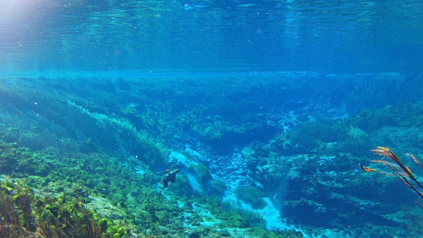
Te Waikoropupū Springs near Takaka are the largest freshwater springs in New Zealand, the largest cold-water springs in the Southern Hemisphere, and are nationally and internationally valued for their remarkable colour and clarity. NIWA has recently finished a project with Tasman District Council (TDC) that has estimated the current average visual clarity to be around 76 m.
In 1993, diver observations by Department of Scientific and Industrial Research (a forerunner to NIWA) measured visibility in the main spring basin at 63 m. At that time, this was the highest reported for any natural fresh water, and about 85% of the then theoretical maximum for optically pure water (74 m). However, a more recent study (2013) in Blue Lake (Nelson Lakes National Park) has shown the theoretical maximum of pure water visibility is at least 83 m.
Twenty-five years on, TDC sought the establishment of a new base-line and guidance for monitoring trends in visual clarity at Te Waikoropupū Springs. Maintaining the existing clarity of Waikoropupū is a key priority identified through TDC’s collaborative planning process with the Takaka community under the National Policy Statement for Freshwater Management. A major challenge was that direct visibility measurements with divers was ruled out to protect the springs, so instrumental deployment, similar to recent Blue Lake studies, was undertaken.
Between mid-October 2017 and mid-January 2018, NIWA deployed a WET Labs C-Star green beam transmissometer in the main spring basin to monitor beam attenuation as a basis for estimating visual clarity. A water quality sonde was co-deployed with the transmissometer to measure a range of other properties at high frequency, including water temperature, dissolved oxygen, specific conductivity and turbidity. TDC staff assisted with monthly servicing and calibration, and collected water samples for laboratory analysis. Also of interest was the light absorption by coloured dissolved organic matter (CDOM), determined in NIWA’s Wellington laboratory using a sensitive long path length (1 m) method.
The green beam transmissometer captured 60 readings in one-minute bursts, every 10 minutes, resulting in nearly a million water clarity estimates over the deployment period. This provided a comprehensive data set to assess how visual clarity in the springs varies over different time scales, from minutes to months.
Use of a standard commercial green beam transmissometer (of only 0.25 m light path) to characterise so clear a water presented challenges in terms of calibration and signal stability and, as a result, there remains uncertainty about the real visibility corresponding to the beam attenuation measurements. However, average visual clarity was estimated to be about 76 m (± 7 m) for the 3-month deployment period. About 95% of the time visibility was above 73 m, confirming the extremely high clarity of Waikoropupū. The clearest estimated visibility was about 81 m—almost that of pure water. Overall, the visual clarity of Waikoropupū is broadly comparable to that of Blue Lake in Nelson Lakes National Park, despite these two spring systems being geologically and hydrologically distinct.
The high frequency and sensitive monitoring detected small daily variations of 1-2 m in visual clarity, with the highest visibility at night, and lowest around midday. This is likely to be due to plants in the spring basin releasing light-scattering oxygen bubbles during the day as they photosynthesise.
Underwater video footage demonstrated that ‘dancing’ white marble sands on the floor of the springs coincided with some short-term—hours to days—episodes of lower visual clarity. Sand disturbance by flow pulses may be associated with release of fine particles that temporarily increase light attenuation in the springs basin. Visual clarity was as low as 4 m for a short time in mid-January following almost 240 mm of rainfall in mid-January that resulted in turbid flood waters entering the springs basin.

