An ambitious international scientific project to study New Zealand’s largest earthquake fault is now enabling scientists to learn more about slow slip earthquakes happening in subduction zones around the world.
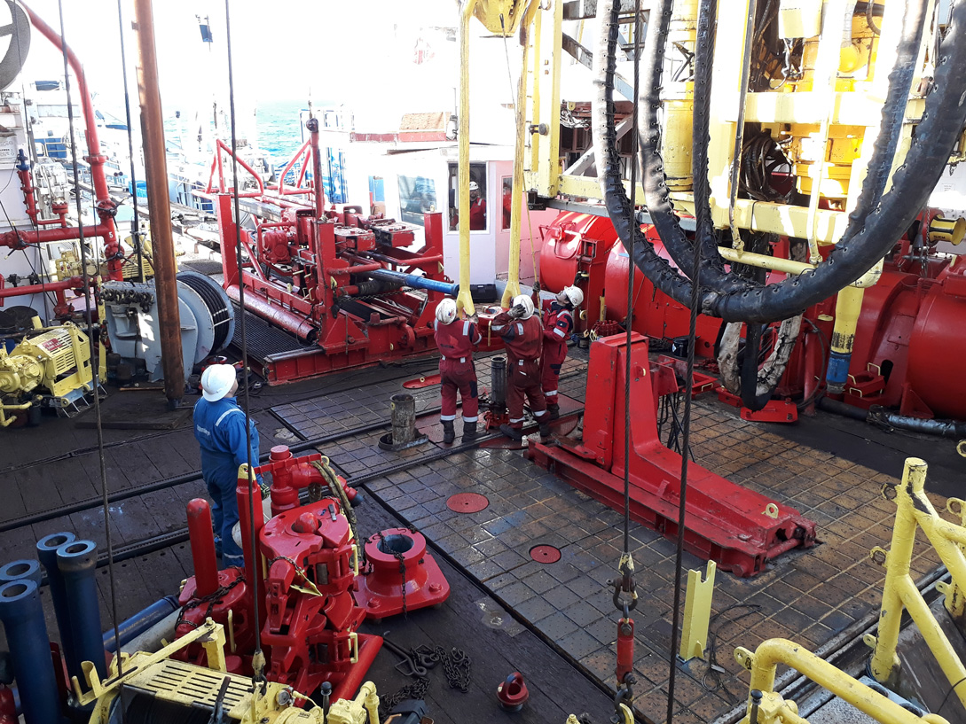
Two International Ocean Discovery Program (IODP) expeditions to the Hikurangi subduction zone off the east coast of the North Island, undertaken in 2017 and 2018, mark the first time scientists from around the world had studied and directly sampled rocks from the source region of slow slip events using ocean floor scientific drilling methods.
The expeditions aboard JOIDES Resolution were jointly led by researchers from NIWA, GNS Science, The University of Texas, and the University of Auckland. Today one of the first scientific papers from the expedition has been published in the prestigious journal Science Advances.
Slow slip events are similar to regular earthquakes but instead of energy being released suddenly and catastrophically, slow earthquakes take place in slow increments that may last from days to months and can recur every year or two.
NIWA principal scientist Dr Philip Barnes, who is the senior author of the paper and jointly led the expedition, says slow slip events are important, not only because they are a newly discovered type of seismic behaviour, but also because they occur in areas which are capable of causing large, damaging earthquakes and tsunami.
“We have the fortune of being able to study slow motion earthquakes near the North Island’s coast, on our Hikurangi subduction zone."
“As slow slip earthquakes are still only newly discovered, we don’t yet understand their relationship to large damaging earthquakes.”
The 2016 Kaikōura earthquake triggered a series of major slow slip events on the Hikurangi subduction zone – where the Pacific Plate dives beneath the eastern North Island. “The 2016 slow slip event was the most widespread episode of slow slip seen in New Zealand since they were first discovered here in 2002”, according to study co-leader Dr Laura Wallace of GNS Science.
Dr Barnes says there is strong international scientific focus on the results of the expeditions because very little is known about slow slip events and “everyone wants to know how, where and why they’re happening and what drives their behaviour”.
Originally seismologists thought subduction zones only slipped in seismic earthquakes (lasting seconds to minutes) or crept continuously, but since 2002, we now know many areas of our plate boundary move in these slow slip events. What causes these slow motion earthquakes however is not well understood.
“For example, could slow slip trigger a large, damaging earthquake and tsunami? Or can the same fault move in both slow and fast slip earthquakes and why would that be?”
Dr Barnes says it was also originally thought that slow slipping faults occurred too deep under the ocean to use ocean floor drilling techniques to sample fault zone rocks, but we now know in New Zealand and a few other locations that they can occur at shallow depths, only a few kilometres beneath the seabed.
New Zealand was identified as one of the best places to study slow slip because these events occur close to the sea floor which made drilling to collect geophysical information and rock samples a viable proposition.
A transect across the plate boundary was drilled off the coast of Gisborne including two boreholes selected with the aim of obtaining a sequence of rocks and sediments on the incoming (Pacific) plate approaching the North Island.
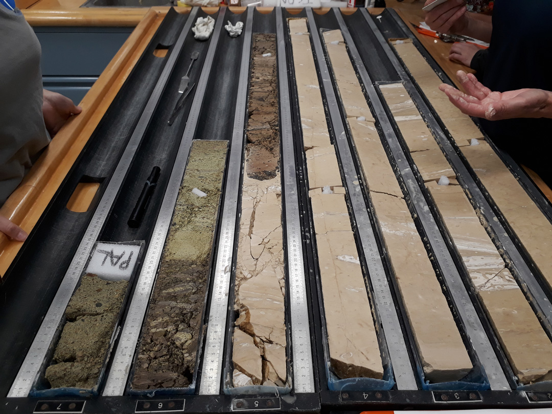
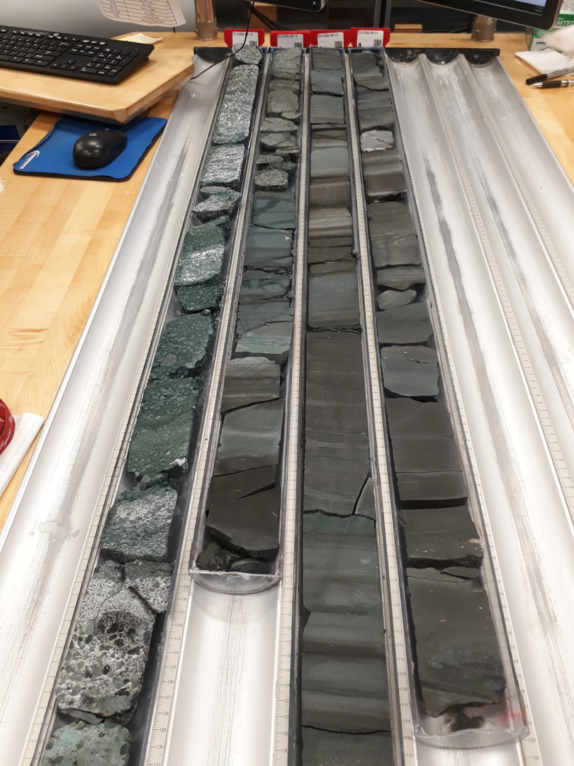
“We collected a core down to just over one kilometre deep in water depths of 3.5 km, to find out the sort of properties the rocks have where slow slip earthquakes occur.”
The drilling data were interpreted together with seismic reflection profiles – or pictures of the layers under the surface of the earth which are created at sea by sound waves. These are used by marine scientists to study sediments and rocks beneath the ocean floor, as well as active faults that represent major earthquake and tsunami hazards.
What they were able to confirm is that the topography in the basement rock layers in the area is extremely rough and the rocks themselves vary markedly in size, type and physical characteristics.
“What we believe is that shallow slow slip events occur on fault zones made up of a mash-up of different rock at different scales that are hugely variable in composition. Some are mushy and weak, while some are really hard, cemented, and strong,” Dr Barnes says.
The study indicates that the co-existence of these contrasting rock types in the fault zone may lead to the slow slip movements observed offshore from Gisborne, and perhaps elsewhere at subduction boundaries around the world.
Scientific monitoring instruments have been installed in two of the boreholes and are now monitoring changes in the earth’s crust at the front line of slow slip, an effort being led by project co-leaders Dr Wallace and Dr Demian Saffer at the University of Texas.
Dr Barnes says the research will have direct relevance not only to New Zealand, but to areas like Japan and Costa Rica, which sit on the Ring of Fire – the perimeter of the Pacific Ocean basin where many earthquakes and volcanic eruptions occur.
Fellow authors of the Science Advances paper, Drs Wallace and Saffer, say the rock samples and geophysical data collected by the International Ocean Discovery Program drilling expeditions has given scientists their first-ever look at the types and properties of rocks directly involved in slow motion earthquakes, helping to unravel the origin of these newly discovered phenomena.
The International Ocean Discovery Program is sponsored by the National Science Foundation and other participating countries.