NIWA meteorologist Ben Noll says parts of the upper North Island have received more rain in two days than normally falls for the entire month.
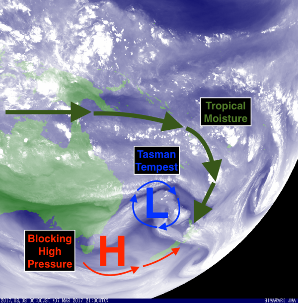
Mr Noll has dubbed this later weather system the Tasman Tempest and warns there is more to come.
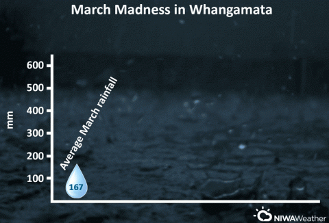
As of midday today, Kawerau in northern Bay of Plenty had recorded an amazing 340.6mm of rain since 12:00am on Tuesday. Similar extremely heavy falls were common across the eastern Coromandel, with Whangamata receiving 259.8 mm in less than 36 hours. That amount of rain is more than 150% of the normal rainfall for the entire month of Marc, Mr Noll says.
The huge amount of rain that fell in Whangamata in 24 hours between 11:00 am on Tuesday and 11:00 am on Wednesday had a return frequency of 1 in 100 years. In that same 24 hour period, Waihi Beach recorded more than 220mm of rain with a return frequency of 1 in 60 years.

While rain across the Bay of Plenty is expected ease from tonight, significant additional rainfall (150+ mm) is expected across the eastern Coromandel as a very moist easterly flow continues to drive tropical downpours toward the Peninsula. Storm total rainfall, through the weekend, may exceed 500 mm in parts of the Coromandel.
Meanwhile, heavy rain will build back into Northland and northern Auckland from late tonight and continue through Friday. Additional rainfall in some locations may exceed 150mm, Mr Noll says.

Another very heavy area of rain may move across most of the North Island, from north to south, from late Friday through Saturday and with it an increased risk for thunderstorms than may contain damaging wind gusts.
All the while, the Tasman Tempest will slowly move closer to New Zealand before possibly passing over the country on Sunday or Monday, causing more downpours.
Why?
An autumn trifecta for meteorologically induced misery: strong and slowing moving low pressure, deep tropical moisture, and a blocking ridge of high pressure to the south.
Strong and slow moving low pressure: The driving force behind all of the adverse weather.
Deep tropical moisture: An atmospheric moisture source from the Indian Ocean, Coral Sea, and Pacific Islands—this is known as an atmospheric river.
Blocking ridge of high pressure: High pressure building to the south and east of New Zealand encourages slow movement of the Tasman Tempest, effectively preventing it from moving over the next several days.
These three factors are causing a weather traffic jam. Think Auckland at 7:30am on a Monday in March.
After the Tempest
The weather is expected to slowly settle across most of New Zealand by the middle stages of next week. By late week and into next weekend, high pressure may be the dominant weather player across the country, bringing plenty of dry weather and gradually warmer temperatures.
Warm and dry “beach-type” weather may actually be the flavour into late March as well: which will be much deserved after the extreme weather that Tasman Tempest brings.


