A weekly update describing soil moisture across the country to help assess whether severely to extremely dry conditions are occurring or imminent. Regions experiencing these soil moisture deficits are deemed “hotspots”. Persistent hotspot regions have the potential to develop into drought.
Facts: soil moisture
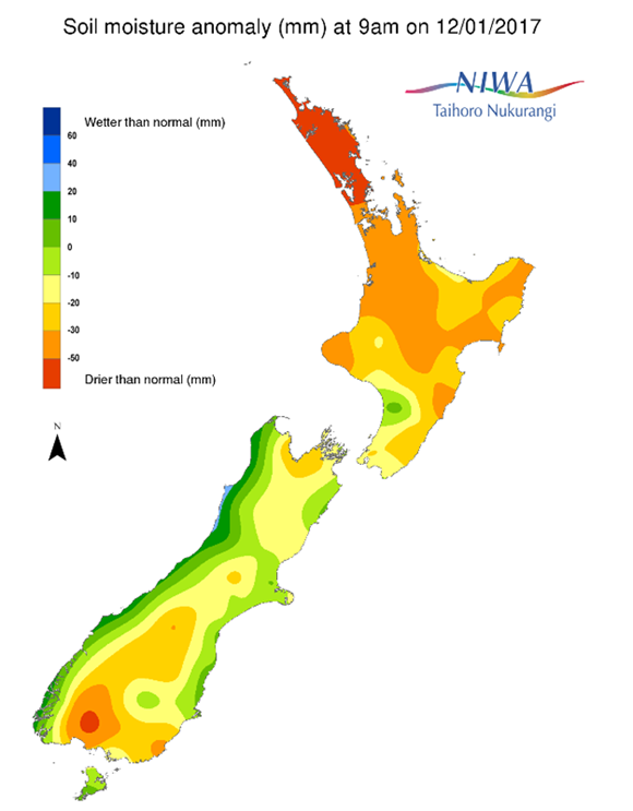
Across the North Island, soil moisture levels have continued to decrease in most locations during the past week. The most substantial decreases were observed in the Coromandel Peninsula, the Bay of Plenty, Gisborne, Hawke’s Bay, and eastern Manawatu-Wanganui. Smaller decreases also occurred in the Wellington region and western Manawatu-Wanganui. Meanwhile, small increases in soil moisture levels were observed in the Ruapehu district and in the Far North near Cape Reinga. The driest soils across the North Island compared to normal for this time of the year are found in much of Northland, northern Auckland, the Coromandel Peninsula, and East Cape, while the wettest soils for this time of the year are found along the west coast of Manawatu-Wanganui.
Hotspots are in place across large portions of the North Island, including all of Northland and Auckland, northern and southern Waikato (including the Coromandel Peninsula), and the entire east coast from Gisborne south to Wairarapa. Soils in these areas are extremely drier than normal. Less severe hotspots also exist in western Wellington and the South Taranaki district.
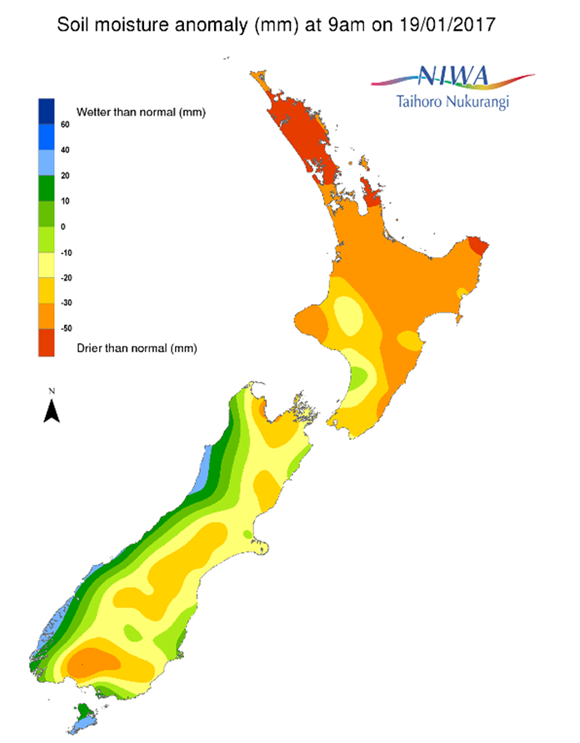
Across the South Island, soil moisture levels have generally decreased in eastern and northern areas while slightly increasing in western and southern areas during the past week. Modest decreases were observed across most of Canterbury, eastern Otago, and near Nelson. Meanwhile, substantial increases were observed in southern Southland, while modest increases occurred in the rest of Southland, interior Otago, and along the West Coast.
Hotspots are in place in Nelson, northeastern Tasman, northwestern Marlborough, Hurunui district, interior southern Canterbury to interior Otago, and a small portion of interior Southland.

Outlook and soil moisture
For the North Island, showers today are delivering modest rainfall amounts of generally less than 10 mm to areas such as Northland and Auckland, although little will be seen along the east coast. Slightly higher amounts up to 15 mm are occurring in the central North Island today. Additional light showers will produce minor accumulations on Friday (20th January) in central and eastern areas. After dry conditions on Saturday, the most significant rain in recent weeks will arrive on Sunday (22nd January). Western and central parts of the North Island could receive 20-30 mm of rain, with 10-20 mm possible in Northland and Auckland. Unfortunately only 10 mm or less is expected along the east coast. Dry weather is anticipated early next week before scattered showers could deliver a few millimetres on Wednesday (25th January).
With the expected rainfall during the next week, soil moisture levels may slightly increase in the central and western parts of the North Island. This may slightly improve the hotspots in southern Waikato and South Taranaki. However, soil moisture levels may continue to decrease in Northland, Auckland and the Coromandel Peninsula, while more significant decreases are expected along the east coast. This will lead to a further strengthening of the hotspots in these areas.
For the South Island, very heavy rainfall yesterday and today produced accumulations in excess of 100 mm for many locations along the West Coast, with amounts closer to 15-25 mm in the southern South Island. More modest amounts generally 10 mm or less occurred in much of Canterbury. Isolated showers on Friday will only produce minimal rainfall before another significant storm arrives for Saturday night and Sunday (22nd January). This will produce 50-100 mm along the West Coast, with perhaps 25-30 mm for Nelson, Otago, and Southland. More modest accumulations of 20 mm or less are expected in eastern areas. After a dry early next week, more heavy rain could reach the West Coast on Wednesday (25th January), with only modest rainfall expected in the eastern South Island.
Heavy rainfall will lead to significant increases in soil moisture levels in the next week along the West Coast, Tasman, and Fiordland. Modest increases are also likely in Southland, Otago, and Nelson. Meanwhile, soil moisture levels will likely remain steady or even decrease slightly in Canterbury and Marlborough. Improvements to the hotspots in the northern South Island, interior Otago and interior Southland are likely, while the hotspot in the Hurunui district may strengthen slightly.
Background
Hotspot Watch: a weekly advisory service for New Zealand media. It provides soil moisture and precipitation measurements around the country to help assess whether extremely dry conditions are imminent.
Soil moisture deficit: the amount of water needed to bring the soil moisture content back to field capacity, which is the maximum amount of water the soil can hold.
Soil moisture anomaly: the difference between the historical normal soil moisture deficit (or surplus) for a given time of year and actual soil moisture deficits.
Definitions: “Extremely” and “severely” dry soils are based on a combination of the current soil moisture status and the difference from normal soil moisture (see soil moisture maps).