The current tropical cyclone season is coming to a close
The current tropical cyclone season is coming to a close. For the current season, there was an expectation of normal or above normal tropical cyclone (TC) activity for most islands west of the International Date Line in the southwest Pacific, with reduced east of the International Date Line. While normal activity is usually confined between November and April, all communities should remain alert and prepared as La Niña continues to wind down.
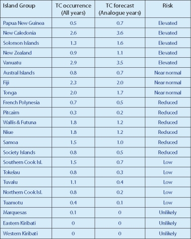
As of the end of April 2011, nine TCs have occurred in the region covered by the ICU forecast. A total of nine to 12 named TCs were forecast for the southwest Pacific (between 135°E to 120°W) between November 2010 and April 2010. On average, nine tropical cyclones occur each year for the southwest Pacific region, which are grouped into classes ranging from 1 to 5, with 5 being the most dangerous. For this season, activity seen thus far has matched the October 2010 forecast that at least three cyclones would reach at least Category 3, and one system would reach at least Category 4, with mean wind speeds of at least 64 knots or 118 km/h.
Each year, TCs have a significant impact on the southwest Pacific. Projections continue to show an increased risk of TCs for the remainder of the 2010–11 season over the Coral Sea and to the southwest of Fiji, particularly for Papua New Guinea, the Solomon Islands, Vanuatu, and New Caledonia. New Zealand is also at higher risk of experiencing an extropical cyclone interaction, even late in the season. While risk is generally reduced for islands to the east of the International Date Line during La Niña, historical cyclone tracks indicate that TCs can affect parts of southwest French Polynesia, including the Society and Austral Islands, and the Cook Islands during La Niñas. The analogue years used in the 2010–11 forecast indicate the TC season could extend into May, and the update issued in February indicated that the total number of named storms could approach the upper end of the forecast range.

