Beach width (defined as the distance between dune crest and shoreline position at high tide) is an important parameter measuring the 'health' of a beach. Understanding how beach width changes over varying timescales is vital for future shoreline management planning, for example, planning beach nourishment or seawall construction, defining hazard setbacks, identifying 'hot spots' (locations of enhanced erosion) and the threat they pose to human structures and/or recreational activities.
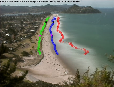
Time-averaged Cam-Era images are used to detect dune crest, the shoreline position (defined as the intersection between dry and wet beach), and the position where wave breaking is focused (usually associated with the presence of submerged sandbars). The figure below shows an example.
Cam-Era collects and analyses averaged images every hour, so that, every day, at each high tide, the position of the dune crest and the shoreline can be evaluated. We have analysed all images for the year 2003 and evaluated a time series of beach widths at the two distinct alongshore locations shown by the black and magenta circles in the previous figure. To account for differences in image resolution (pixels farther away from the camera cover a larger area) and algorithm inaccuracies (mainly related to changes in light conditions), the time series have been smoothed using a Loess interpolator and the dune position used in the calculations of beach width is the average over the whole year. Results are shown in the figure below.
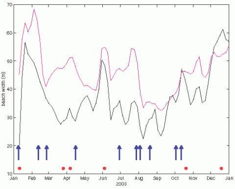
Notice how the beach width at the two locations can differ from each other throughout the year (end of March and beginning of April in particular). Also notice the slow but continuous increase in beach width throughout spring and summer (from September onwards). Blue arrows indicate beginning of storm events characterized by offshore significant wave height larger than 2m. Click on the red circles to see images of Pauanui Beach at different times of the year and how the shoreline detection algorithm works.