El Niño Impacts in the Pacific, now and for the Southern Hemisphere Summer
Ashmita Gosai, Andrew Watkins, Luc Maitrepierre, and Stuart Burgess


Sea surface temperature (SST) anomalies are now very positive in the equatorial Pacific from the date line across to the South American coast. At the same time, the November and September-November means of the Southern Oscillation Index (SOI) remained close to –1.0, indicating steady, but moderate El Niño conditions.
The El Niño has already impacted Pacific countries in the equatorial and western Pacific, one example being the prevalent drought conditions in both Australia and New Caledonia, and reduced rainfall in the eastern parts of New Zealand.
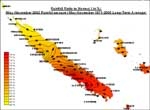
In New Caledonia, rainfall has been below average for six of the past seven months, the composite average being only 38% of normal for the May – November 2002 period (Figure 1), resulting in significant soil moisture deficits and bush fires around the country. This has had a large impact on the country’s cattle industry that has had to resort to hay, as the natural pastures have been destroyed by the dry conditions.
Similarly, rainfall deficiencies have intensified in the eastern states of Australia over the last eight months (April to November 2002). Serious to severe rainfall deficiencies cover about half of Victoria and most of Queensland and New South Wales, resulting in outbreaks of bushfires in eastern New South Wales and northern Victoria. The impact on winter crop has been large. The Australian Bureau of Agricultural and Resource Economics (ABARE) have indicated that the winter harvest will be the smallest since 1994-1995, with an estimated 57% of the previous years crop tonnage. The Reserve Bank of Australia has estimated that the impacts of the dry conditions on the economy will be similar to those experienced in the drought of 1982 (BOM Annual Preliminary Summary, 2002).
On the other hand, equatorial countries like Kiribati have been experiencing above average rainfall for the most part of 2002 (Figure 2).
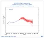
The majority of the global climate models indicate that the current El Niño conditions will weaken by the autumn of 2003. Figure 3 shows SST anomaly predictions (red lines) into the autumn of 2003, from the European Centre for Medium Range Forecasting. The thick dotted line is based on the observed SST anomaly.
