Tropical rainfall and SST outlook: May to July 2010
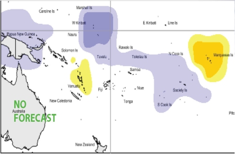
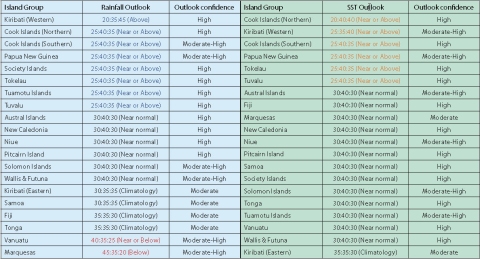
During May – July 2010, a region of suppressed convection is likely in the southwest Pacific encompassing Vanuatu and the Marquesas. Near or below and below average rainfall is expected for those island groups, respectively. Enhanced convection is likely along the Equator, and above average rainfall is expected for Western Kiribati. Near or above average rainfall is forecast for Papua New Guinea, the Northern Cook Islands, The Southern Cook Islands, Tuvalu, Tokelau, the Tuamotu Archipelago and the Society Islands. Near normal rainfall is forecast for the Solomon Islands, New Caledonia, Niue, Wallis & Futuna, the Austral Islands and Pitcairn Island. No clear precipitation guidance is offered for Tonga, Fiji, Samoa, or Eastern Kiribati.
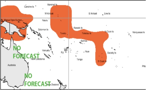
Some of the global models have shown a shift in the near equatorial Pacific sea surface temperatures to cold anomalies east of Eastern Kiribati in the coming months. Cold anomalies that existed around Tonga and Niue in previous months have dissipated in nearly all of the models used in the ensemble. For May to July 2010, average or above average sea surface temperatures are forecast for Western Kiribati, Papua New Guinea, the Northern Cook Islands, the Southern Cook Islands, Tuvalu and Tokelau. No clear SST guidance is offered for Eastern Kiribati. Near normal SSTs are forecast for the remainder of the southwest Pacific.
The confidence in the multi–model ensemble forecast skill for this seasonal rainfall outlook is moderate to moderately high. In the past, the average region-wide hit rate for rainfall forecasts issued in May is 56%, 7% lower than the long–term average for all months combined. The SST forecast confidence is mostly moderately high, but the greatest uncertainty is localised around Eastern Kiribati, Fiji, Tonga and Samoa.

Rainfall outlook map for May to July 2010

SST outlook for May to July 2010

NOTE: Rainfall and sea surface termperature estimates for Pacific Islands for the next three months are given in the tables above. The tercile probabilities (e.g., 20:30:50) are derived from the averages of several global climate models. They correspond to the odds of the observed rainfall or sea surface temperatures being in the lowest one third of the distribution, the middle one third, or the highest one third of the distribution. For the long term average, it is equally likely (33% chance) that conditions in any of the three terciles will occur. *If conditions are climatology, we expect an equal chance of the rainfall being in any tercile.
