What causes undersea quakes?
The same thing as on land: rupture of a fault. New Zealand is riddled with faults created by the collision of the Pacific and Indo–Australian tectonic plates. Some are just on land. Some are under the sea (‘submarine’). Others straddle land and sea. We’ve found hundreds of faults in the Bay of Plenty alone, but overall, marine geologists have probably identified only about half of New Zealand’s submarine faults.
How do we know where the faults are?
It can be difficult, even on land, as Christchurch’s experience shows. We use multibeam echosounders mounted on ships to gather high-resolution data on water depth, and we then make digital 3-D colour maps of the seafloor. This will show up surface features, but won’t pick up faults that don’t reach the surface, or features masked by sediments.
To look deeper, we use seismic reflection profiles to view a virtual slice of the geology beneath the seafloor. Our equipment sends and receives sound signals that can penetrate as deep as 15 kilometres below the seafloor. The signals bounce back (‘reflect’) where there are density differences in the underlying sediment and rock, generating characteristic reflections on seismic profiles. Faults show up on these profiles as displaced sedimentary layers and rock strata.
How often do undersea earthquakes happen?
That depends on many factors, including the overall movement of the tectonic plates and interactions between neighbouring faults. If we want to predict when the next earthquake is likely to be, we need to know the time since the last earthquake and how much the intervals between earthquakes on that fault vary. So we have to study their earthquake history over several earthquake cycles. Phil and one of our colleagues, Nicolas Pondard (now at Willis Ltd, London), developed a method of doing this for submarine faults, using seismic reflection profiles. They tested it on the Wairau, Cloudy, and Vernon Faults in Cook Strait.
Those three faults are all strike-slip faults, which mostly move the rocks on either side of the fault sideways, but also involve some vertical displacement that forms a fault scarp (a small bluff). Sediments preferentially accumulate on the lower side of the scarp, forming ‘growth layers’. The bottom of these growth intervals marks the time when an earthquake occurred. By estimating or dating the age of the sediments at the bottom of each growth sequence, scientists can estimate the timing of earthquakes and intervals between them, as seen on the Cloudy Fault seismic reflection profile.
Phil and Nicolas recorded earthquakes on the Wairau, Cloudy, and Vernon Faults going back to the last Ice Age 18 000 years ago – longer than any earthquake record on nearby land. For example, they detected at least six prehistoric earthquakes of magnitude seven or more on the Cloudy Fault, which last ruptured about 1800 years ago. Earthquakes occurred on this fault every 2700 years on average, vertically displacing the seafloor sediments by an average of 2.7 metres.
How big and dangerous are they?
The size of submarine earthquakes depends on the size and type of fault that causes them. A combination of fault length, depth, and angle determines its overall size or area. Because it’s on a low angle, a thrust fault (where one side is pushed over the other), has a bigger surface area than a vertically aligned fault that reaches the same depth in the Earth’s crust. In many cases thrust faults can generate bigger earthquakes, especially at ‘subduction’ zones, where one tectonic plate is being thrust beneath the other. The danger that active faults pose depends not only on their size, but also on the rate of displacement, and location, relative to where buildings and people are. Many submarine faults that lie within about 100 kilometres of the coast have the potential to cause strong earthquake ground shaking or tsunami on adjacent land. For instance, the Wairau, Vernon, and Cloudy Faults all pose a major earthquake and tsunami hazard to central New Zealand. A rupture on one fault can put stress on another, triggering further quakes sooner than otherwise, if the faults overlap closely. In New Zealand, earthquakes are unlikely to spread from the North Island to the South Island, because the overlap of the faults from one island to another isn’t sufficiently close. Do all big quakes generate tsunami?
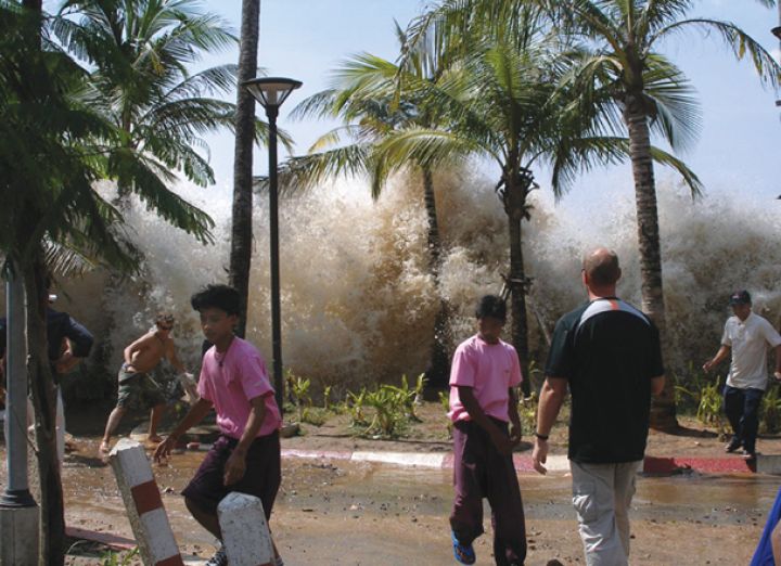
Ruptures of any of the big faults can cause tsunami if they move the seafloor sufficiently to displace the water above. Shallowly dipping thrust faults have the greatest potential to displace water over enormous areas. The massive tsunami in Indonesia on Boxing Day 2004, for instance, was caused by a 1200-kilometre-long megathrust fault.
Strike-slip faults tend to be less of a threat, displacing water over much smaller areas. A normal fault (where most movement is vertical) will also create more localised water displacement. Earthquakes on the Wairau, Cloudy, and Vernon strike-slip faults typically involve several metres of vertical displacement, so they could produce local tsunami. Scientists determine future earthquake and tsunami hazards with probabilistic models, using information on return times, magnitude, and long-term ‘slip rates’ (how fast the two sides of a fault are slipping relative to one another), among other things.
Dr Fiona Proffitt, NIWA science writer
More information
Both are members of the NIWA Ocean Geology Group.