A mild and wet September
|
Temperature |
Temperatures were near average (±0.50°C of average) for most of the country. Small areas of above average temperatures (0.51°C to 1.20°C above average) were observed in the Coromandel, eastern coastal Auckland, and the Canterbury Plains. Discontinuous pockets of below average temperatures (0.51°C to 1.20°C below average) occurred in parts of Waikato, Bay of Plenty, Nelson, Otago and Southland. |
|
Rainfall |
Rainfall was below normal (50-79% of normal) or well below normal (<50% of normal) about the Bay of Islands, southern Waikato, northern Taranaki, the Kāpiti Coast, and much of the Canterbury Plains. Above normal (120-149% of normal) or well above normal rainfall (>149% of normal) was observed across most of Northland, Auckland, northern Waikato, Bay of Plenty, eastern and southern Hawke’s Bay, parts of Taranaki, Manawatū-Whanganui, Wellington, Tasman, Nelson, Marlborough, along the Southern Alps, and much of Otago and Southland. Near normal rainfall (80-119% of normal) was observed elsewhere. |
|
Soil Moisture |
At the end of the month, and for the time of year, soil moisture levels were lower than normal near the Bay of Islands, eastern parts of Hawke’s Bay to the south of Napier, near Banks Peninsula, and a small area of eastern Otago. Soil moisture levels were higher than normal for eastern parts of North Canterbury and Marlborough, parts of Auckland, parts of Otago, eastern Hawke’s Bay and eastern Gisborne. Soil moisture levels were typically near normal for most remaining parts of New Zealand. |
Overview
September 2021 was characterised by higher than normal mean sea level pressure (MSLP) over the North Island and top of the South Island, with lower than normal MSLP over the south of the South Island, as seen in the map. This resulted westerly flow anomaly across most of Aotearoa New Zealand.
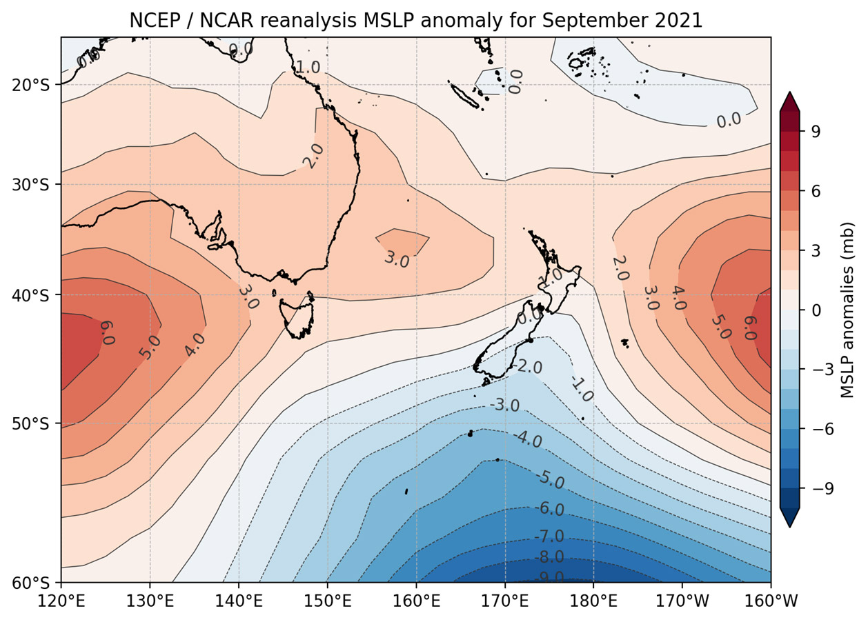
These westerlies brought several strong frontal systems, resulting in periods of wet and windy weather. One such front brought gusts in excess of 140 km/h to parts of the South Island and North Island during mid-September (see the highlights and extreme events section for more details). However, these unsettled periods were interspaced by dry and calm weather. Such changeable weather is typical of spring.
A lack of strong global climate drivers during September resulted in a patchwork of rainfall and temperature patterns across the country. Conditions in the equatorial Pacific were neutral, although NIWA remained at La Niña Watch as ocean temperatures in the equatorial Pacific continued to cool.
During September, the Southern Annular Mode (SAM) was positive. The SAM is a proxy for the location of a belt of westerly winds that encircle the South Ocean and occasionally protrude into the mid-latitudes. Usually, a positive SAM can indicate calmer and drier conditions for New Zealand. However, New Zealand experienced relatively wet and windy conditions during September. This is because the region of anomalously high pressure was located away from New Zealand during September, and frontal systems favoured a track that brought them over New Zealand at times.
Overall, most of New Zealand experienced a mild month, with near average (±0.50°C of average) for most of the country. Small areas of above average temperatures (0.51°C to 1.20°C above average) were observed in the Coromandel, eastern coastal Auckland, and the Canterbury Plains. Discontinuous pockets of below average temperatures (0.51°C to 1.20°C below average) occurred in parts of Waikato, Bay of Plenty, Nelson, Otago and Southland. Overall, the nationwide average temperature in September 2021 was 10.7°C. This was 0.2°C above the 1981-2010 September average.
Generally, above normal rainfall was more common than below normal rainfall in September. Above normal (120-149% of normal) or well above normal rainfall (>149% of normal) was observed across most of Northland, Auckland, northern Waikato, Bay of Plenty, eastern and southern Hawke’s Bay, parts of Taranaki, Manawatū-Whanganui, Wellington, Tasman, Nelson, Marlborough, along the Southern Alps, and much of Otago and Southland. Rainfall was below normal (50-79% of normal) or well below normal (<50% of normal) about the Bay of Islands, southern Waikato, northern Taranaki, the Kāpiti Coast, and much of the Canterbury Plains. Near normal rainfall (80-119% of normal) was observed elsewhere.
Further highlights
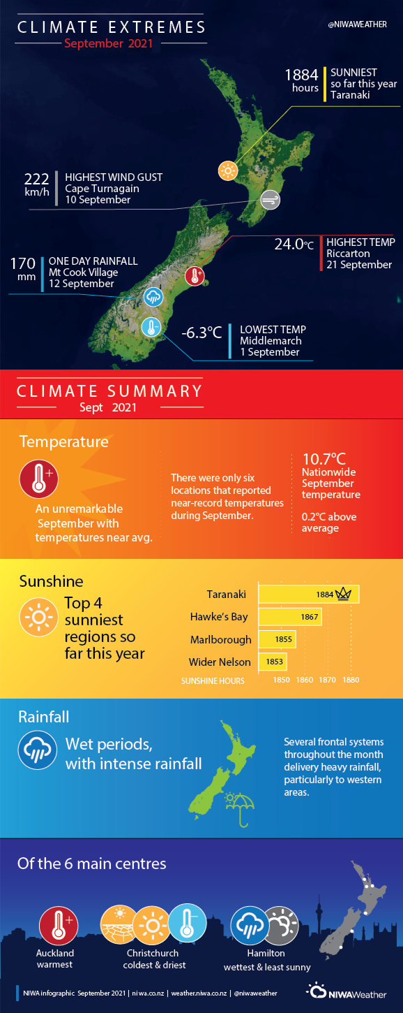
- The highest September temperature was 24.0°C, observed at Christchurch (Riccarton) on 21 September.
- The lowest September temperature was -6.3°C, observed at Middlemarch on 1 September.
- The highest 1-day rainfall was 170 mm, recorded at Mount Cook Village on 12 September.
- The highest wind gust was 222 km/h, observed at Cape Turnagain on 10 September.
- Of the six main centres in September 2021, Auckland was the warmest, Christchurch was the sunniest, driest and coldest, and Hamilton was the wettest and least sunny.
- Of the available, regularly reporting sunshine observation sites, the sunniest four regions in 2021 so far are Taranaki (1884 hours), Hawke’s Bay (1867 hours), Marlborough (1855 hours), and Wider Nelson (1853 hours).
Download
Climate Summary - September 2021 [PDF 320KB]