Dry for most locations, drought for upper South Island
|
Temperature |
Temperatures were above average (0.5 to 1.2°C above average) or well above average (>1.2°C above average) for much of New Zealand with areas of near average temperatures (-0.5 to +0.5°C of average) in the eastern and lower North Island as well as the upper and western South Island. |
|
Rainfall |
February rainfall was below normal (50-79% of normal) or well below normal (<50% of normal) for most of the country. Above normal (120-149% of normal) or well above normal (>149% of normal) rainfall was observed for parts of Gisborne, coastal Southland, and north Canterbury (between Kaikoura and Waipara) while near normal rainfall (80-119% of normal) was mostly restricted to the east coast of the North Island (south of Napier) and small pockets in several locations around the country. |
|
Soil Moisture |
At the end of February, drier than normal soils were present across much the country. Severely dry soils were present across Northland, Auckland, Bay of Plenty, Waikato and Manawatu-Whanganui and extremely dry soils were present in the Taranaki, Tasman and Nelson regions. Meteorological drought conditions (as defined by the NZ Drought Index) were present at the end of February in Nelson, Tasman and the Buller District. |
Overview
Mean atmospheric pressure during February was near normal over much of New Zealand with lower than normal pressures to the north and south. This pressure setup resulted in a slightly enhanced northwest flow over the South Island and slightly more east-southeast winds than normal for the North Island.
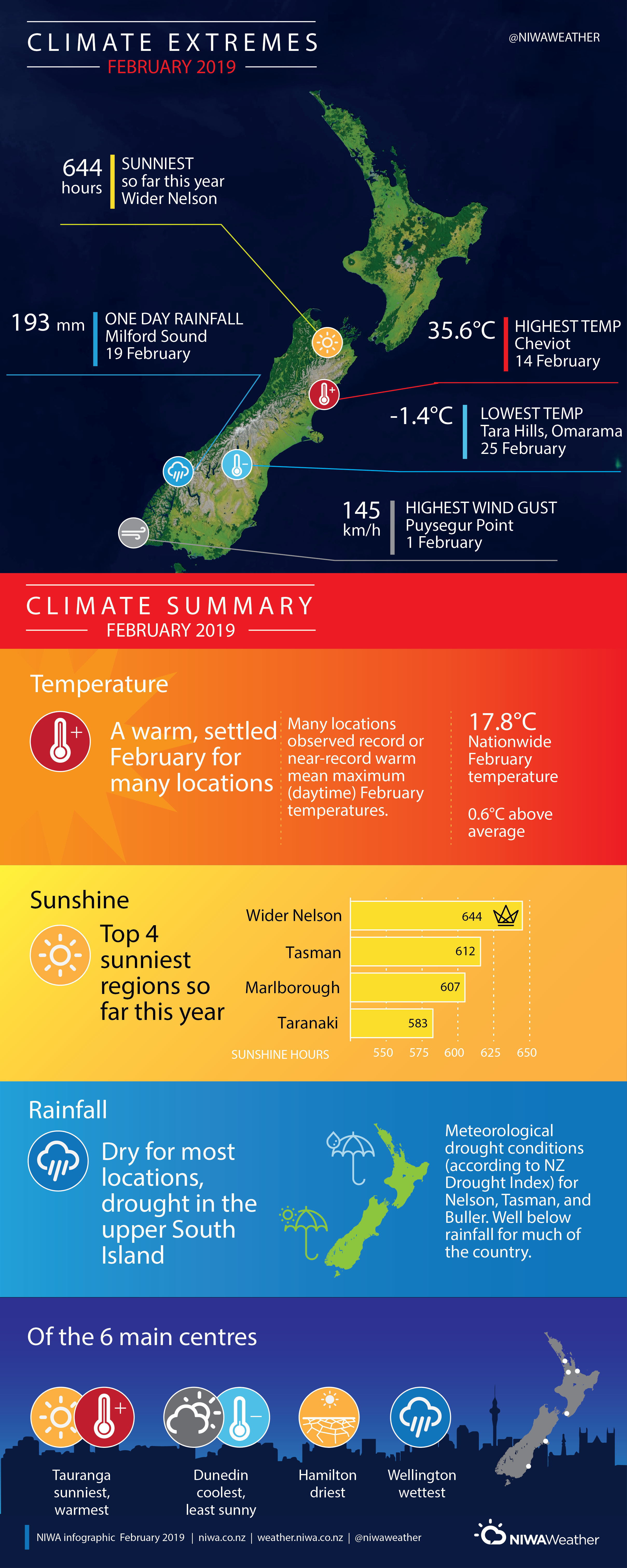
February was a warm month for many with large parts of the country receiving above average (0.5 to 1.2°C above average) or well above average (>1.2°C above average) temperatures while some locations observed near average temperatures (-0.5 to +0.5°C of average). The nationwide average temperature in February 2019 was 17.8°C (0.6°C above the 1981-2010 February average from NIWA’s seven station temperature series which begins in 1909). Several locations experienced record mean maximum air temperatures, notably Cheviot where daytime maximum temperatures were 3.8°C warmer than average for the time of year.
Dry conditions prevailed for much of the country during February, with many locations receiving below or well below normal rainfall totals. Having followed a dry January, this resulted in several locations reaching meteorological drought conditions as well as extreme levels of fire risk. Multiple fires arose throughout the month, one of which resulted in a Civil Defence State of Emergency in the Tasman region between 6 and 27 February (refer to the Highlights and extreme events section for details). Several long dry spells came to an end near the end of the month as tropical moisture moved across the north of the country while a southerly approached from the south. The dry weather came hand in hand with plentiful sunshine during February.
Further highlights
- The highest temperature was 35.6°C, observed at Cheviot on 14 February
- The lowest temperature was -1.4°C, observed at Tara Hills, Omarama on 25 February.
- The highest 1-day rainfall was 192.8 mm, recorded at Milford Sound on 19 February.
- The highest wind gust was 145 km/h, observed at Puysegur Point on 1 February.
- Of the six main centres in February 2019, Tauranga was the warmest and sunniest, Dunedin was the coolest and least sunny, Wellington was the wettest, and Hamilton was the driest.
- Of the available, regularly reporting sunshine observation sites, the sunniest four regions in 2019 are Wider Nelson (644 hours), Tasman (612 hours), Marlborough (607 hours) and Taranaki (583 hours).
Download
Climate Summary for February 2019 [PDF 1MB]
Climate Statistics for February 2019 [PDF 70 KB]
Contact
John-Mark Woolley, Climate Research Scientist Tel. 09 375 6337