A weekly update describing soil moisture patterns across the country to show where dry to extremely dry conditions are occurring or imminent. Regions experiencing significant soil moisture deficits are deemed “hotspots”. Persistent hotspot regions have the potential to develop into drought.
Recent rainfall and current soil moisture conditions:
North Island:
- It was a dry week for the North Island. Several stations recorded no rainfall, including parts of Auckland city, Hamilton, Taupō, Hick’s Bay, Whakatu (near Hastings), Levin, and Masterton.
- Due to afternoon showers on 9 February, some sites recorded totals over 30mm in the Central North Island, including Okahune and Taurmaranui.
- This resulted in widespread soil moisture decreases across North Island.
- The driest soils across the North Island, when compared to normal for this time of the year, are found in eastern Northland, while the wettest soils for this time of the year are found in southern Waikato.
- Hotspots have expanded over the last week and are currently located in much of Northland, northern Bay of Plenty, East Cape, parts of Wellington-Wairarapa and coastal Manawatū-Whanganui.
- As of 13 February, the New Zealand Drought Index (NZDI) map below shows that abnormally dry conditions are currently found in parts of Northland, Auckland, and much of the lower North Island. Very dry to extremely dry conditions are located near the Bay of Islands, southern Manawatū-Whanganui, and Wellington.
South Island:
- Widespread rainfall amounts of more than 50-150 mm affected Fiordland in and West Coast in the last week, with the heaviest totals across the Alps and ranges. Milford Sound recorded 141 mm, with 119 mm falling in a day. Areas near the coast received 10-50 mm, with Hokitika receiving 1 mm.
- Lower Southland received 10-40 mm, such as Invercargill receiving 12 mm, and some showers delivered 1-10 mm to parts of Otago, including Queenstown which observed 7 mm, with Cromwell and Alexandra observing 2 mm apiece.
- Some showers about Canterbury were heavy last weekend, and delivered 10-30 mm to some areas. Kaikōura received 25 mm in a day, about half of their monthly normal, but was otherwise dry. Lincoln near Christchurch recorded 20 mm in a day last weekend, but was otherwise dry.
- However, much of the week was dry, and large parts of Tasman, Nelson, Marlborough, and Canterbury were either dry or received less than 5mm.
- Soil moisture decreases were generally observed everywhere except parts of north Canterbury and Southland.
- The driest soils across the South Island, when compared to normal for this time of the year, are found in Nelson, Marlborough, and parts of eastern Otago, while the wettest soils for this time of the year are found in Southland.
- Hotspots have emerged in eastern Tasman, Nelson, Marlborough, and eastern Otago.
- As of 13 February, the New Zealand Drought Index (NZDI) map below shows that abnormally dry conditions are currently found in Tasman, Canterbury, and eastern Otago. Very dry to extremely dry conditions are in eastern Tasman, Nelson, Marlborough, parts of Canterbury, and northern Otago. Previously observed areas of meteorological drought have dissipated but may return in the next week.
![Soil moisture anomaly map (mm) at 9am on 6 February 2024. [NIWA]](/sites/default/files/styles/wide/public/2024-02/smdanom_20240206.png?itok=mj-_dAkQ)

Pictured above: Soil Moisture Anomaly Maps, relative to this time of year. The maps show soil moisture anomalies over the past two weeks.
As of 13 February, the New Zealand Drought Index (NZDI) map below shows that abnormally dry conditions are currently found in parts of Northland, Auckland, much of the lower North Island, Tasman, Canterbury, and eastern Otago. Very dry to extremely dry conditions are located near the Bay of Island, southern Manawatū-Whanganui, Wellington, eastern Tasman, Nelson, Marlborough, parts of Canterbury, and northern Otago. Previously observed areas of meteorological drought have dissipated but may return in the next week. Please note: some hotspots in the text above may not correspond with the NZDI map. This difference exists because the NZDI uses additional dryness indices, including one which integrates the rainfall deficit over the past 60 days. Changes are therefore slower to appear in the NZDI compared to soil moisture anomaly maps that are instantaneously updated.
![New Zealand Drought Index (NZDI) - 13 February 2024 [NIWA]](/sites/default/files/styles/wide/public/2024-02/NZDI_2.png?itok=_NuEFB-c)
The week ahead:
North Island:
- The week ahead looks mostly dry again, aside from the chance of some showers.
- Afternoon showers and isolated thunderstorms look to occur for the central and lower North Island this weekend (16 – 17 February).
- Showers look to become more widespread on Monday through to Wednesday, first affecting western areas, then eastern areas later.
- Weekly rainfall totals look to reach 5-15 mm for many areas, although some areas that get several rounds of showers could see as much as 20-30 mm.
- Otherwise, some areas in the lower North Island may only receive 5 mm or less.
- Due to the expected rainfall in the next week, moderate soil moisture decreases may occur in much of the North Island, although generally minor change is expected in central regions.
- The current hotspots in eastern could both strengthen further in the next week.
South Island:
- This weekend (16-17 February) looks to be generally dry, aside for the chance of isolated afternoon showers for some inland areas.
- Widespread rainfall look to affect Southland and West Coast from Monday, with some areas of lighter rain and showers with possible thunderstorms for Otago and eastern Canterbury Monday – Wednesday. Some of these showers and thunderstorms could bring some heavier, but brief, rainfall.
- After that, conditions will quickly dry out again, with settled weather for the remainder of the week.
- Weekly rainfall totals look to be 50-100 mm for parts of the elevated West Coast and Fiordland, with 5-15 mm for Southland.
- Showers and thunderstorms associated with a southerly change on Monday – Wednesday could bring up to 30 mm to some isolated areas in Otago, Canterbury and eastern Marlborough, but otherwise less than 5-10 mm is predicted.
- Many areas look to be largely dry for the entire week, including Nelson, parts of Tasman, parts of Marlborough, parts of Canterbury, and parts of Otago.
- Due to the expected rainfall in the next week, additional soil moisture decreases are likely in the for much of the South Island, except Southland where soil moisture will remain the same or slightly increase.
- Hotspots will likely worsen in the next week.
Long-term outlook (through mid-March):
- The drier (25th percentile) and middle (50th percentile) rainfall scenarios show drier or much drier than normal conditions across nearly the entire country.
- Even in the wetter (75th percentile) scenario, below normal rainfall is still forecast for several regions across both islands.
- Such agreement across all three rainfall scenarios gives an increased confidence in drier than normal conditions in the coming weeks.
- Very dry soil conditions could continue to affect the lower North Island and eastern South Island in all three rainfall scenarios, along with the upper North Island in the drier scenario. Small areas of meteorological drought could occur indicated in parts of Wairarapa and the eastern South Island in the drier scenario.
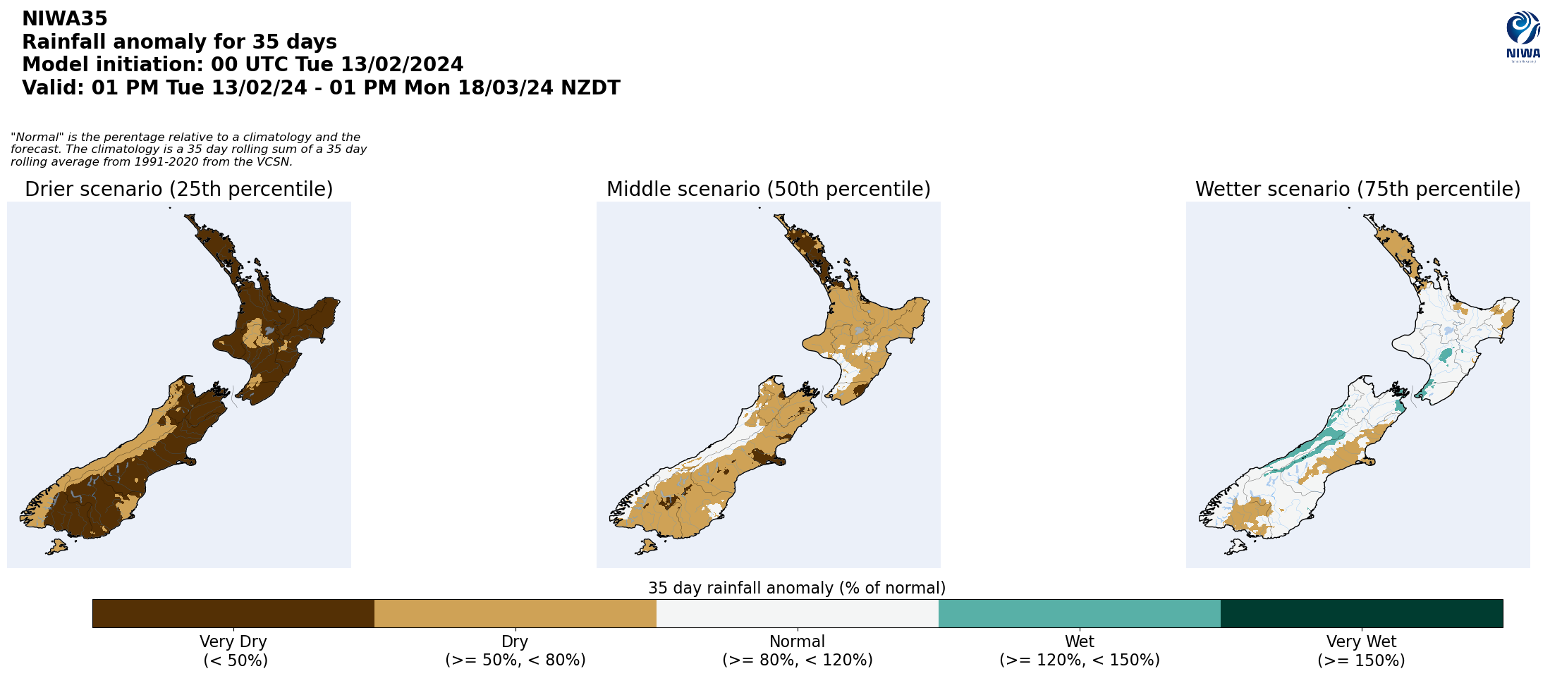
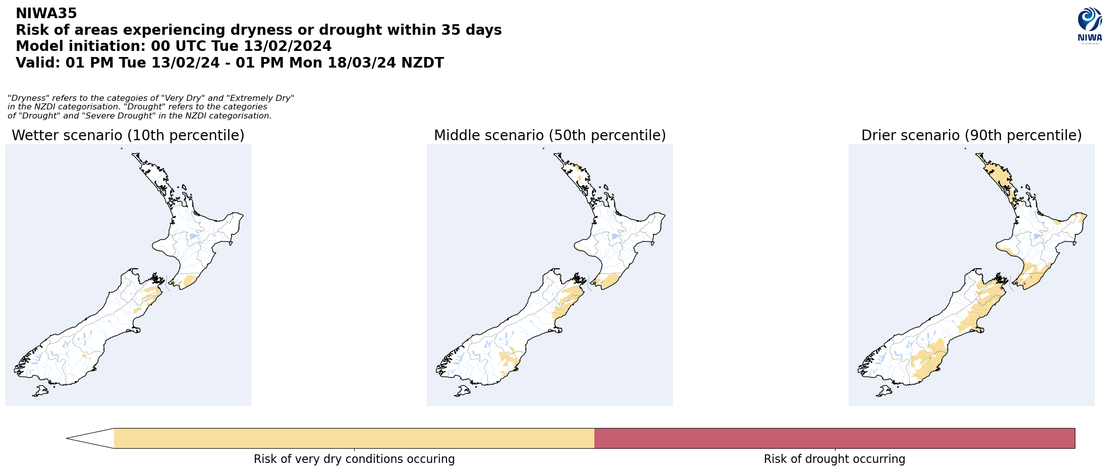
Pictured above: 35-day forecast rainfall anomaly scenarios (Top), and 35-day forecast dryness and drought scenarios (Bottom). These maps are updated daily at https://niwa.co.nz/climate/seasonal-climate-outlook
Background:
Hotspot Watch: a weekly advisory service for New Zealand media. It provides soil moisture and precipitation measurements around the country to help assess whether extremely dry conditions are imminent.
Soil moisture deficit: the amount of water needed to bring the soil moisture content back to field capacity, which is the maximum amount of water the soil can hold.
Soil moisture anomaly: the difference between the historical normal soil moisture deficit (or surplus) for a given time of year and actual soil moisture deficits.
Definitions: “Extremely” and “severely” dry soils are based on a combination of the current soil moisture status and the difference from normal soil moisture (see soil moisture maps at https://www.niwa.co.nz/climate/nz-drought-monitor/droughtindicatormaps)
Hotspot: A hotspot is declared if soils are "severely drier than normal" which occurs when Soil Moisture Deficit (SMD) is less than -110 mm AND the Soil Moisture Anomaly is less than -20 mm.
