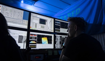
A state-of-the-art underwater Remotely Operated Vehicle (ROV) called ROPOS is helping a team of New Zealand and US scientists study the Hikurangi subduction zone, where the Pacific Plate subducts beneath the east coast of the North Island.
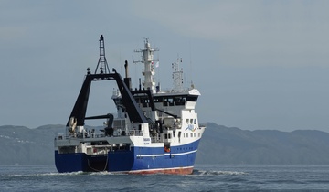
Scientists from GNS Science, NIWA and University of Washington are currently onboard NIWA’s research vessel Tangaroa on a five-day voyage to the Hikurangi subduction zone.
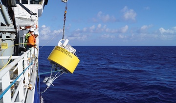
During the voyage, ROPOS will download the latest data from the two observatories monitoring earthquakes and slow slip earthquakes and retrieve seafloor instruments installed along the Hikurangi subduction zone. Voyage leader Dr. Laura Wallace of GNS Science says scientists cannot wait to see what the data can tell them about the slow slip earthquakes that have occurred over the last few years. “We’re also keen to learn more about last week’s 7.1 magnitude earthquake near East Cape, which was only about 100 km away from the offshore observatories. “We hope this data will help us figure out why these slow slip earthquakes are occurring on the Hikurangi subduction zone and to better understand the processes that occurred in the East Cape earthquake.”The two earthquake observatories were installed beneath the seafloor by the research vessel JOIDES Resolution more than three years ago and have been actively recording changes in the Earth’s crust due to earthquakes and slow slip earthquakes off the coast of Gisborne since then.
This is the first time the Canada-based ROPOS will be operating in New Zealand waters, to download the information from the Hikurangi subduction zone observatories. ROPOS is operated on Tangaroa by a team of eight engineers from the Canadian Scientific Submersible Facility. It will take about one to two hours to download the three years’ worth of data from the observatories once the robot plugs itself into the observatory. Scientists are interested in understanding the relationship between earthquakes and slow slip earthquakes. Slow slip earthquakes appear to occur every one to two years off New Zealand’s east coast. Unlike a normal earthquake, which releases built-up stress suddenly, a slow slip event happens over a longer period – anything from days to weeks to months.
ROPOS will also be used to retrieve 16 seafloor instruments, which have been measuring the rate of water flowing out of the seafloor and collecting water for chemical analyses. University of Washington Associate Professor Evan Solomon says the information and samples being collected will help improve understanding of the role that water, deep beneath the seafloor plays, in the timing and occurrence of slow earthquakes along the Hikurangi subduction zone. “Working with international science partners is vital to the success of large science projects like this, as they bring technologies not currently available in New Zealand,” says Dr Wallace.
The voyages are supported by funding from the New Zealand Ministry for Business, Innovation, and Employment, and by the United States National Science Foundation.