
Waves from Satellites
Waves from Satellites
Waves are available from a number of satellite sensors, including radar altimeters and synthetic aperture radar (SAR).

A radar altimeter aims a narrow beam directly downwards. From the spread in the return signal, the wave height can be measured. Since 1985 five space missions carrying radar altimeters have each provided continuous wave information over several years: SEASAT (1978), GEOSAT (1985-1988), ERS1 and ERS2 (1991+), and TOPEX/Poseidon (1992+), Jason-1 (2002+) .
All of the four satellites sampled at a high rate along-track (see picture left), but the spacing of the tracks varied considerably. The satellites are usually in orbital configurations which repeat a fixed lattice pattern of sampling the ocean surface every few days.
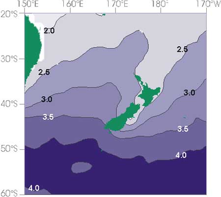
For each satellite mission the data for the oceans surrounding New Zealand (60°S-20°S, 150°E to 170°W) were quality checked and sorted into 2° by 2° latitude/longitude squares. The monthly wave parameters for each mission were then calibrated and combined into a single climatology of monthly mean fields.
The figure on the left shows the overall average of significant wave height (in metres) derived from satellite observations.

Synthetic Aperture Radar (SAR) uses a type of radar antennna designed to take advantage of their satellite’s movement, thus creating a "synthetic" aperture or opening.
The intensity of backscatter is related to surface roughness and incidence angle.
Missions:
SEASAT (1978)
Space Shuttle:
SIR-A (1981), SIR-B (1984), SIR-C (1994)


