
Global setting and climate outlook
Global setting and climate outlook
La Niña conditions have developed

Difference from average global SST (click to enlarge).
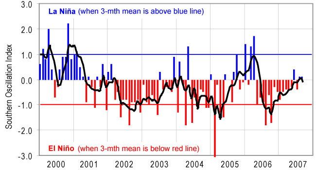
Monthly SOI values (click to enlarge).
La Niña conditions have become more developed in the tropical Pacific over the last month. Sea surface temperatures in the equatorial Pacific have become more strongly negative during the month, especially in the east (see map below), and the area of cold anomaly has expanded westward to the Dateline. There is about a 50% chance of La Niña conditions persisting through to the end of summer 2007–08.
Sea surface temperatures(SST) around New Zealand
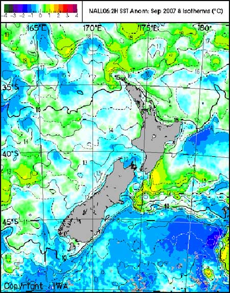
New Zealand SST (click to enlarge).
Sea surface temperature (SST) anomalies in the New Zealand region continued to weaken in September to +0.2 °C, with the July–September average anomaly about +0.4 °C. SST anomalies are positive around the North Island coast and across to the central Pacific, but remain negative south of Chatham Rise and southeast of the South Island. Over the next three months, sea surface temperatures are expected to be above normal around the North Island and near normal east of the South Island.
Outlook for October to December 2007
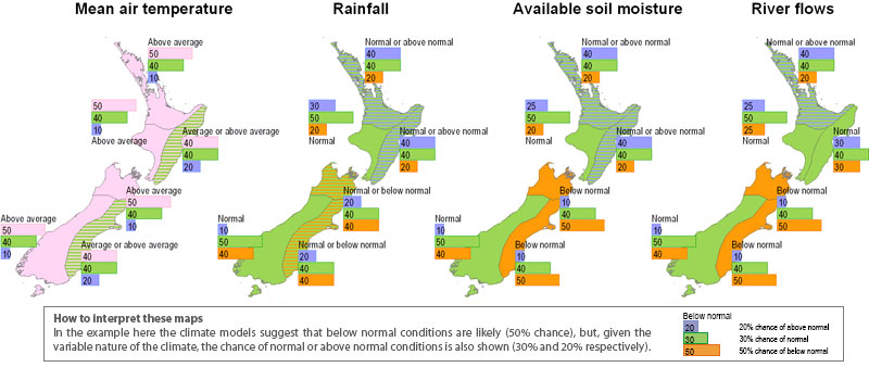
Regional outlook (click to enlarge).
Over the coming late spring period, mean sea level pressures are expected to be higher than normal to the south and southeast of New Zealand and lower than normal to the north, with weaker than normal westerly winds, on average.
Air temperatures are likely to be average or above average over most of New Zealand. Rainfall is expected to be normal or above normal in the north and east of the North Island, normal or below normal in the north and east of the South Island, and normal elsewhere. Soil moisture levels and stream flows are likely to be below normal in the north and east of the South Island, and normal or above normal elsewhere.
There is a slightly lower than normal chance of an ex-tropical cyclone passing within 500 km of New Zealand in the coming tropical cyclone season (November 2007–May 2008).