
February's climate
New Zealand climate in February 2006

Rainfall (click to enlarge).

Temperature (click to enlarge).
Rainfall was almost 300% of normal in parts of eastern Bay of Plenty. Above normal rain fell in inland Bay of Plenty, Taupo, Kapiti, Wellington, central Wairarapa, and isolated parts of Nelson, the Marlborough coast, north Canterbury, and Southland. In contrast, rainfall was 25% of normal or less throughout much of Northland, Auckland, and coastal Wairarapa, and 50% or less of normal in Central and East Otago. It was drier than normal in Taranaki, south Westland, and Fiordland.
Mean temperatures were above average in parts of Auckland, Bay of Plenty, Hawke’s Bay, Manawatu, Horowhenua, Canterbury, and Otago. They were below average in Westland, and near average elsewhere.
For more information on the climate in February, visit the climate summaries page at www.niwascience.co.nz/ncc/cs/mclimsum_06_02
Widespread dry conditionsSoil moisture (click to enlarge). Northland soils that were well watered in January lost most of their moisture during February. East coast and southern North Island soils also became drier during the month. |
High flows in the north and low in the south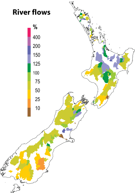 River flows (click to enlarge). Normal to above normal stream flows occurred in much of the North Island and in parts of Marlborough and north Canterbury. Low stream flows occurred in Taranaki, the southern North Island, and over most of the South Island. Stream flows were extremely low in the South Island alpine catchments. |
December 2005 to February 2006: the climate we predicted and what happened

(click to enlarge).
Rainfall
Rainfall was lower than expected in the east of the North Island, but mostly as predicted elsewhere except for wet conditions in the far south.

(click to enlarge).
Air temperature
Air temperatures were above average in many areas as predicted.

(click to enlarge).
River flows
Normal or above normal streamflows in much of the North Island and coastal Southland; below normal in Taranaki, Wairarapa, Kapiti Coast, and much of the rest of the South Island.
The three outcome maps give the tercile rankings of the rainfall totals, mean air temperatures, and mean river flows that eventuated from December to February, in comparison with the forecast conditions.
As an approximate guide, middle tercile rainfalls typically range from 80 to 115% of the historical normal, and middle tercile temperatures range about the average by plus or minus 0.5 °C.