
Three-month outlook
The outlook for March 2004 to May 2004
Below average mean sea-level atmospheric pressures to the south of the country may somewhat enhance westerly quarter winds through autumn. This is likely to bring relatively cool conditions to New Zealand and above normal rainfall in western areas. Local sea surface temperatures are likely to be warmer than average around the northern North Island, but below average in the south of the country.
The Equatorial Pacific is in a neutral state, and no El Niño or La Niña is expected through autumn 2004.
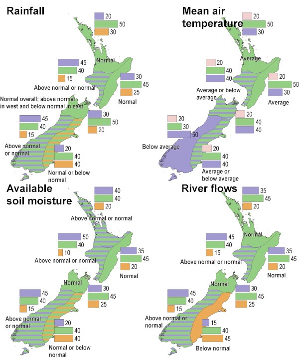
Rainfall is expected to be normal or above normal in western areas, normal or below normal in the eastern South Island, and near normal elsewhere. Average or below average temperatures are likely in all regions.
Soil moisture levels and river flows are expected to be normal or above normal in western regions, normal or below normal in the east of the South Island, and near normal elsewhere.
Despite the recent passage of ex-tropical cyclone Ivy, there is a continuing risk of an ex-tropical cyclone affecting New Zealand over the remainder of the cyclone season.

A. Climate models give no strong signals about how the climate will evolve, so we assume that there is an equal chance (33%) of the climate occurring in the range of the upper, middle or lower third (tercile) of all previously observed conditions.
B. There is a relatively strong indication by the models (60% chance of occurrence) that conditions will be below average, but, given the variable nature of climate, the chance of average or above-average conditions is also shown (30% and 10% respectively).