There were floods, tornados, fires and big waves in another year of big weather for New Zealand. NIWA climate scientists review the inclement highlights month by month in our first Summer Series feature for 2015.
Weather overview for January 2015
- Highest temperature 36.4°C, at Timaru on 16 January.
- Lowest temperature 0.4°C, at Lumsden on 21 January.
- Highest 1-day rainfall 146 mm, at Milford Sound on 11 January.
- Highest wind gust 148 km/hr, at South West Cape on 4 January.

Dry conditions and high temperatures combined to elevate fire danger levels throughout much of New Zealand during January. On 19 January, several small fires were reported in the upper South Island, including one near Seddon which forced the closure of SH1 and disrupted train services on the main trunk line.
On 26 January a large fire started near Arthur’s Pass affected nearly 500ha. High temperatures in subsequent days resulted in a number of hots-spots flaring up.
From 25-28 January, Wellington recorded a four day “warm spell” (consecutive days with a daily maximum temperature greater than 25°C). This is the equal second-longest warm spell for Wellington since records began in 1927.
On 19 January lightning strikes and hail were reported near the east coast of North Otago.
On 21 January thundery showers brought hail to isolated parts of Hawke’s Bay including Hastings and Havelock North. Masterton was also struck by a sudden downpour which caused minor surface flooding.
A thunderstorm hit Queenstown on the evening on 30 January, with lightning strikes reported near the airport. The town received 55.4mm of rainfall on this day, which is 87% of the normal total January rainfall.
Weather overview for February 2015
- Highest temperature 33.5°C, at Waiau, North Canterbury, on 1 February.
- Lowest temperature -1.5°C, at Ranfurly on 26 February.
- Highest 1-day rainfall 194 mm, at North Egmont on 1 February.
- Highest wind gust 150 km/hr, at South West Cape on 4 February.
On 1 February an Air New Zealand flight was struck by lightning near Dunedin. A thunderstorm struck near Ettrick, Central Otago, with hail causing significant damage to crops.
On 4 February, strong winds in Canterbury brought down trees and power lines, and fanned a number of vegetation fires that forced the evacuation of some residents and schools. Dust storms were reported in Christchurch and 5000 Canterbury customers were affected by power cuts.
Further north, a large forest fire broke out between the Onamalutu Valley and SH 6 north-west of Renwick (Marlborough). On 6 February strong winds brought down power lines in central Auckland, cutting power to 1300 homes in Newmarket.
On 11 February, a blinding flash similar to lightning lit up the sky over much of New Zealand about 10 pm, and a sonic boom was also heard. The flash was caused by a meteor entering the atmosphere.

Weather overview for March 2015
- Highest temperature 32.1°C, at Hanmer Forest on 5 March.
- Lowest temperature -2.4°C, at Pukaki on 19 March.
- Highest 1-day rainfall 111 mm, at Westport on 5 March.
- Highest wind gust 145 km/hr, at Hicks Bay on 16 March.
On 5 March, heavy rain fell in the Buller and Grey Districts, causing slips that blocked roads, flooding of 17 homes, and the closure of SH6 through the Buller Gorge.
On 6 March, three shipping containers were tossed into Wellington Harbour by strong winds. In Christchurch, a plane slid off the runway as it was landing due to strong winds and heavy rain. On 7 March, thunderstorms brought torrential rain to Wellington.
On 16 March, about 2000 Auckland properties lost power overnight as ex-Tropical Cyclone Pam, passed the country.
On 17 March, all schools in the Gisborne region were closed due to the forecasted impact of ex-Tropical Cyclone Pam. More than 100 people in the East Cape area were evacuated from their homes as a precaution.
Parts of SH35 around East Cape, as well as local roads, were closed due to slips and tree falls. Power was out to several communities around the East Cape and Mahia Peninsula. A local state of emergency was declared on the Chatham Islands. Ex-Tropical Cyclone Pam caused high seas around the eastern coast of the North Island, with waves in excess of 9m recorded in the western Bay of Plenty and the East Cape/Gisborne area.
On 22 March, heavy rain was welcomed near Motueka after a tanker carrying cream tipped over and the cream flowed into the Riwaka River.

Weather overview for April 2015
- Highest temperature 30.4°C, at Cheviot on 7 April.
- Lowest temperature -4.8°C, at Hanmer Forest on 15 April.
- Highest 1-day rainfall 206 mm at North Egmont on 8 April.
- Highest wind gust 170 km/hr, at South West Cape on 7 April.
On 2 April, fog caused flight delays at Christchurch Airport. On 10 April, low cloud caused two flights scheduled to land in Queenstown to be diverted to Invercargill.
On 13 April and 14 April, an unseasonable fall of snow to very low elevations occurred in the lower South Island. Flights due to arrive at Queenstown Airport were cancelled or diverted because of snow on the runway.
In Dunedin, bus services on some of the hill routes were suspended on the morning of 14 April after overnight snow. Snow fell to low levels on Banks Peninsula near Christchurch, and forced the temporary closure of Dyers Pass Road. SH 6 from Kingston to Dipton and SH 94 between Te Anau and Milford Sound were closed due to snow.
On 27 April, strong winds occurred throughout the North Island. Auckland was particularly hard-hit, with boats torn from their moorings and pushed up against rocks along Tamaki Drive. Motorists were warned to take extra caution on the Desert Road (SH 1) and the Rimutaka Hill Road (SH 2) due to strong winds.
Weather overview for May 2015
- Highest temperature 27°C at Waiau, 6 May
- Lowest temperature -9°C at Hanmer Forest, 28 May
- Highest1-day rainfall 190mm at North Egmont, 6 May
- Highest wind gust 178km/h at Cape Turnagain, 13 May
On 6 May torrential rain, flooding and strong winds hit the West Coast of the South Island. SH6 at Haast Pass was closed due to a slip.
On 12 May it was Wellington’s turn, resulting in significant sflooding and the cancellation of Victoria University’s graduation parade. Meanwhile, a mini tornado caused damage in Urenui, north of New Plymouth.
On 14 May torrential rain caused flooding in Kapiti, Porirua and Lower Hutt. A slip blocked the road and rail link between the Kapiti Coast and Wellington closing SH1. All train services across the Wellington region were cancelled, trapping thousands of commuters in Wellington. At least 20 homes were evacuated at Raumati Beach and schools closed.
The Hutt and Waikanae Rivers burst their banks. A man was swept under a bridge in Paraparaumu and helped to safety by bystanders. An elderly man’s body was found near his car which was underwater in Petone.
On the same day a tornado ripped through Mt Maunganui resulting in about 20 homes having their roofs lifted. Part of the roof and grandstand of Baypark Stadium was severely damaged.
On 24 May torrential rain caused power outages in Auckland and strong southwest winds affected much of the country.
Weather overview for June 2015
- Highest temperature 21.7°C, at Cheviot on 1 June.
- Lowest temperature -21.0°C, at Tara Hills on 24 June.
- Highest 1-day rainfall 454 mm, at North Egmont on 19 June.
- Highest wind gust 189 km/hr, at Cape Turnagain on 29 June.
On 3 June, Dunedin was inundated by very heavy, prolonged rainfall, which resulted in significant flooding.
Numerous slips were reported along Otago Peninsula and dozens of road closures were enforced. The Fire Service responded to 345 events, with the vast majority of those in the South Dunedin area. Dunedin received 113 mm of rainfall in the 24 hours to 9 am on 4 June – its second-highest 1-day rainfall total for June on record.
On 8 and 9 June, a strong northwest airflow covered the South Island and resulted in very high temperatures for the time of year in many locations. On 9 June, Cromwell and Lauder reached a maximum temperature of 21.0°C – their highest June temperatures on record.
On 9 June strong winds caused two shipping containers to fall into the harbour, one of which later washed up at Oriental Bay. Power was cut to nearly 2000 homes in Wellington due to high winds. In north Canterbury, a wildfire covering approximately 50 hectares was fanned by strong winds, making it difficult for fire services to control.
On 14 and 15 June, massive waves slammed into Wellington’s south coast, washing debris over roads and inundating properties at Lyall Bay.
Overnight on 18-19 June, torrential rain in Hokitika caused significant flooding and many people, including 20 retirement home residents, were evacuated. Some 21mm of rain fell in Hokitika in the 24 hours to 9 am on 19 June – its highest 1-day rainfall total for June on record.
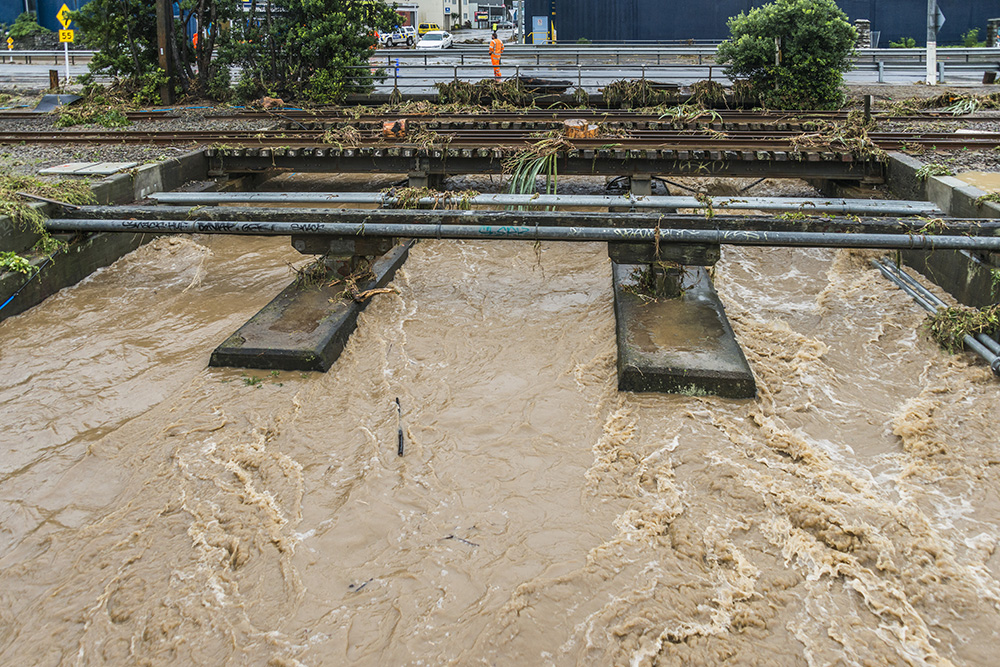
The worst flood on record for Whanganui occurred over 20-21 June, and a state of emergency was declared. On 20 June, heavy rain continued for the Kapiti Coast, Wairarapa, Manawatu and Whanganui areas, causing widespread slips, flooding, and road closures.
More than 100 households in Whanganui were evacuated on 20 June. The Whanganui River breached its banks around midnight, spilling floodwaters into Whanganui’s CBD.
On 21 June, Whanganui was cut off by road. A state of emergency was also declared in Rangitikei and Taranaki after heavy rainfall and flooding in those regions.
During the nights and early mornings of 23-26 June, record-low temperatures for New Zealand were recorded.
During the second night of very cold temperatures on 24 June, Tara Hills, a climate station near Omarama, recorded a low temperature of -21.0°C, which is the lowest temperature officially recorded in New Zealand in 20 years (excluding high altitude stations
During this period, three out of the 10 lowest temperatures ever recorded in New Zealand were experienced (excluding high elevation alpine sites).
Due to the cold temperatures in the central South Island, outdoor ice skating rinks opened.

Weather overview for July 2015
- Highest temperature 21.2°C, at Christchurch on 26 July.
- Lowest temperature -10.2°C, at Hanmer Forest on 12 July.
- Highest 1-day rainfall 91 mm, at Franz Josef on 14 July.
- Highest wind gust 152 km/hr, at Cape Turnagain on 5 July.
On 7 July thunderstorms resulted in heavy downpours for parts of Auckland and Waikato.
On 15 July floodwaters closed the road to Auckland Airport’s domestic terminal, and leaks were reported in both the domestic and international terminals. Fire crews responded to dozens of flood-related calls, and pumped water from more than 50 flooded homes across West Auckland. Auckland Airport recorded 51 mm of rain between 6 and 8pm.
On 13 July and 14 July the National Bonspiel was held in Naseby – the first outdoor curling championship in New Zealand for three years.
On 18 July, approximately 9000 customers in Northland, Auckland, Coromandel Peninsula and Bay of Plenty were without power as a result of strong winds causing trees to fall onto power lines. The strong winds tore off roofs, smashed boats into sea walls and twisted traffic lights in parts of Auckland, and numerous trees were felled. At Ardmore Airport, two light aircraft were flipped upside down by the wind. Water spouts and mini tornadoes were reported farther south at Mount Maunganui.
Weather overview for August 2015
- Highest temperature 23.8°C, at Christchurch on 3 August.
- Lowest temperature -11.5°C, at Lake Tekapo on 11 August.
- Highest 1-day rainfall 134 mm, at North Egmont on 5 August.
- Highest wind gust 141 km/hr, at Cape Turnagain on 19 August.
On 3 and 4 August, a warm northwesterly flow caused numerous high minimum temperature records to be set for that time of year.
On 6 August, Opunake experienced flooding due to heavy rain, the same day strong winds brought down power lines to parts of the Waikato and Bay of Plenty.
On 14 August a small tornado caused damage near Katikati.
Snow closed SH 94 from Te Anau to Milford Sound intermittently from 3 to 7 August.
Overnight on 7-8 August, Arthur’s, Lewis and Haast Passes were all closed due to snow as was SH94 from Te Anau to Milford Sound and the Desert Rd.
On 9 August, snow showers affected areas around the central North Island. Snow fell at the Chateau Tongariro, the largest amount since 2008.
Snow continued to affect South Island roads and the Riimutaka Hill Rd for most of the month. Snow settled in the northern Hawke’s Bay town of Wairoa, for the first time in living memory.
On 10 August, soft hail known as graupel, fell around Auckland, covering some areas in a blanket that resembled snow. Impressive lightning displays were observed in some areas and thunder booms shook houses.
Weather overview for September 2015
- Highest temperature 25.7°C, at Christchurch on 16 September.
- Lowest temperature -7.0°C, at Hanmer Forest on 8 September.
- Highest 1-day rainfall135.4 mm, at Tutira, Hawke’s Bay on 20 September.
- Highest wind gust 167 km/hr, at Cape Turnagain on 4 September.
On 1 September an active low pressure system brought heavy downpours to the North Island, top of the South Island and the West Coast. Road closures were widespread due to flooding.. In Auckland, the combination of high rainfall and the King Tide closed Tamaki Drive causing traffic to back up for 5 kilometres.
On 2 September an unexpected 15cm snow dump in Makarora knocked out power and felled trees.
On 11 September a southerly blast brought the total snow level for the 2015 season on Coronet Peak to a new record.
On the night of 20 September, a stalling low to the east of the North Island began to direct heavy rainfall to the Gisborne region with many residents waking up to surface flooding. The town of Te Karaka was cut off on both side.
The widespread flooding lead to Karaka and Tolaga Bay area schools to be closed. The extreme flooding in Wairoa left two adults and two children stranded in their car for 18 hours.
On 20 and 21 September strong winds affected northern Taranaki. The strong winds sent trampolines flying, tore roofing off sheds and cancelled flights in and out of New Plymouth.
Weather overview for October 2015
- Highest temperature 31.8°C, at Kaikoura on 7 October.
- Lowest temperature -3.7°C, at Pukaki Aerodrome on 26 October.
- Highest 1-day rainfall 291 mm, at Milford Sound on 16 October.
- Highest wind gust 172 km/hr, at Cape Turnagain on 5 October and South West Cape on 7 October.
Much of the first week of October was dominated by a north-westerly airflow. This contributed to temperatures which were considerably warmer than normal for the time of year.
On 4 October very strong winds occurred throughout the South Island. At least 2200 homes in Canterbury and Otago were without power as winds brought down trees onto power lines.
A dust storm struck in Twizel, where the strongest winds were replaced by rain and thunder during the afternoon. A caravan was blown off the road near Tekapo. Flights at Invercargill Airport were cancelled due to wind gusts which peaked at 130 km/hr.
A combination of very strong winds, high temperatures and low humidity created the perfect recipe for extreme fire danger in eastern parts of the South Island on 7 October. Four homes were damaged by a large fire which burned on Saddle Hill (south of Mosgiel).
Several buildings were destroyed by a vegetation fire near Dunsandel, Canterbury, and SH75 near Akaroa was closed due to an uncontrolled fire.
On 18 October, strong winds hit southern and eastern parts of the South Island and again on 21 October.
Weather overview for November 2015
- Highest temperature 31.7°C, at Hastings on 26 November.
- Lowest temperature -5.6°C, at Snowdon (Canterbury) on 5 November.
- Highest 1-day rainfall was 166 mm, at Mount Cook Village on 26 November.
- Highest wind gust 170 km/hr, at Puysegur Point on 27 November.
In the early hours of 13 November, dozens of helicopters were deployed over Marlborough Vineyards to fight off frost. This works by introducing turbulence into the stable air, breaking down the near-surface inversion which reduces the likelihood of frost.
On 26 November in Riverton, the grandstand roof at the local racecourse was torn off by gales. Farther north, a large forest fire was fanned by gale winds in the Waikakaho Valley near Blenheim. In addition, a total fire ban was declared in Marlborough as strong winds, high temperatures and very dry conditions contributed to an elevated fire risk.
On 27 November, strong winds intensified over much of the country. At least seven helicopters were used to fight a forest fire at Whareama, near Masterton, with strong winds meaning conditions were too dangerous for firefighters to tackle the blaze from the ground. Numerous roads were closed and power was out across parts of the Southern Lakes and Central Otago.
The final week of November saw persistent north-westerly airflows that resulted in relatively high temperatures throughout the country. During this time, a number of locations observed record or near-record high daily maximum and daily minimum air temperatures.
Source: NIWA Monthly Climate Summaries www.niwa.co.nz/climate/summaries
Further information
More 2015 weather related stories from NIWA:
Tropical Cyclone Pam heads south
Is extreme weather the new normal?
Temperature records broken around the country
The tempers and tantrums of spring
Scientists examine links between Northland deluge and climate change
El Niño keeps New Zealand cooler in 2015