For 3 November 2016
This week's update describing soil moisture across the country to help assess whether severely to extremely dry conditions are occurring or imminent. Regions experiencing these soil moisture deficits are deemed “hotspots”. Persistent hotspot regions have the potential to develop into drought.
Facts: soil moisture
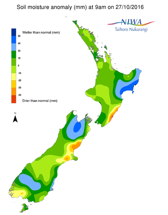
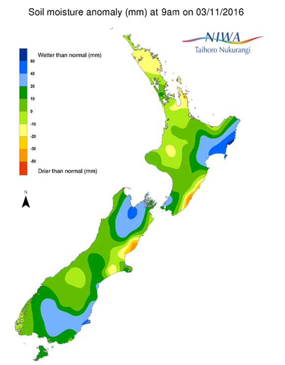
Across the North Island, soil moisture levels have not exhibited much change over the last week. Only minor decreases are noted in Waikato and Northland. Soil moisture levels have increased very slightly around Wellington. Compared to normal for this time of the year, the driest soils on the North Island are still found in coastal Wairarapa, while the wettest are found in northern Hawke’s Bay and southern Gisborne.
Across the South Island, soil moisture levels have not changed significantly compared to this time last week. The driest South Island soils compared to normal for this time of the year are found in northern Canterbury, while the wettest are found in Nelson, eastern Tasman, and western Marlborough. Soil moisture levels are also above normal across interior Southland and much of Otago.
Outlook and soil moisture
Over the next week, frequent fronts and passing areas of low pressure are forecast to give locally heavy rainfall to the country. Two heavy rain events may target parts of the North Island, one from Sunday into Monday and then another later in the week. Some flooding might result from one or both of these events.
There is some chance that a subtropical area of low pressure could approach the country late in the week or over the weekend (11-13th November), bringing downpours.
Across the central North Island, isolated showers will total generally less than 5 mm in the east on Friday (4th November) and less than 5 mm in the Central Plateau on Saturday. A stronger front is expected to deliver some heavier showers and perhaps a few thunderstorms on Sunday and then slowly move east of the Island later on Monday. There is the potential for locally heavy rainfall and perhaps flooding. While two-day rain totals are forecast to average 10-25 mm across the central and northern North Island, localized amounts to 75 mm are possible across the Central Plateau. High pressure building from the north is currently forecast to bring more settled weather for Tuesday and Wednesday. A couple of light showers are possible on Thursday. From Friday (11th November) into the weekend, low pressure tracking from the northwest may deliver another round of heavy rain, though the exact track of this feature is uncertain at this time.
For the South Island, showers will bring 5 to 15 mm on Friday, the heaviest of which will target Otago and Southland (the regions that presently have the wettest soils). A nor’wester is expected to bring a heavy rain event for Fiordland, the West Coast, and the north of the South Island from late Saturday through Sunday with rain totals 25 to 75 mm for many and isolated amounts in excess of 100 mm. Some rain is forecast to spill over the divide, with Southland and Otago generally receiving 5 to 15 mm. Farther north, totals in middle and northern Canterbury (where the driest soils are) may only total 5 mm or less. Early next week, rains will continue to target the southwestern part of the island. Heavier rains may streak up the West Coast on Wednesday with some spilling over the Alps, especially into Southland and Otago. Once again, significant precipitation is not favoured across middle and northern Canterbury. Late in the week and into the weekend, low pressure tracking across the Tasman may bring another round of heavy rain, though the exact track is uncertain at this time.
Official hotspot areas are unlikely to develop across the North Island over the next week. The status of the driest soils in coastal Wairarapa and northern Canterbury are most likely to stay unchanged. Soils across much of Southland and Otago are expected to remain sufficiently moist, contributing to generally good conditions for early in the growing season.
Background
Hotspot Watch a weekly advisory service for New Zealand media. It provides soil moisture and precipitation measurements around the country to help assess whether extremely dry conditions are imminent.
Soil moisture deficit: the amount of water needed to bring the soil moisture content back to field capacity, which is the maximum amount of water the soil can hold.
Soil moisture anomaly: the difference between the historical normal soil moisture deficit (or surplus) for a given time of year and actual soil moisture deficits.
Definitions: “Extremely” and “severely” dry soils are based on a combination of the current soil moisture status and the difference from normal soil moisture (see soil moisture maps)